Geolokalisieren
👉 Easily get elevation data in JSON, GeoTIFF and KML formats using Elevation API
Vielen Dank für die Unterstützung dieser Website ❤️
Spenden

Topografische Karte Agdangan

Klicken Sie auf die Karte, um die Höhe anzuzeigen.

👉 Easily get elevation data in JSON, GeoTIFF and KML formats using Elevation API
Vielen Dank für die Unterstützung dieser Website ❤️
Spenden

Über diese Karte

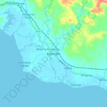
Name: Topografische Karte Agdangan, Höhe, Relief.

Ort: Agdangan, Calabarzon, 4304, Philippines (13.83594 121.87418 13.91594 121.95418)

Durchschnittliche Höhe: 18 m

Minimale Höhe: -3 m

Maximale Höhe: 148 m

👉 Easily get elevation data in JSON, GeoTIFF and KML formats using Elevation API
Vielen Dank für die Unterstützung dieser Website ❤️
Spenden

Andere topografische Karten

Klicken Sie auf eine Karte, um ihre Topografie, ihre Höhe und ihr Relief anzuzeigen.

Manila

Philippines > Manila

Almost all of Manila sits on top of centuries of prehistoric alluvial deposits built by the waters of the Pasig River and on some land reclaimed from Manila Bay. Manila's land has been altered substantially by human intervention, with considerable land reclamation along the waterfronts since the American…

Durchschnittliche Höhe: 6 m

Tanauan

Philippines > Batangas

Durchschnittliche Höhe: 217 m

Guimaras Island

Philippines > Guimaras

Durchschnittliche Höhe: 28 m

La Mesa Eco Park

Philippines > Quezon City

Covering an area of 33 hectares (82 acres) the public park is located along the natural boundary of the La Mesa Watershed Reservation and its elevation is about 40 metres (130 ft) below than the resorvoir.

Durchschnittliche Höhe: 66 m

Vielen Dank für die Unterstützung dieser Website ❤️
Spenden

Mactan

Philippines > Cebu > Lapu-Lapu

Durchschnittliche Höhe: 3 m

Zamboanga del Norte

Philippines

It has an average elevation of 243.8 metres (800 ft), with Mount Dabiak in Katipunan as the highest peak at 2,600 metres (8,500 ft). Other parts, near the coastlines, are plains. The province's irregular coastline runs some 400 kilometres (250 mi) from north to south.

Durchschnittliche Höhe: 78 m

Taysan

Philippines > Batangas

Durchschnittliche Höhe: 203 m

Jomalig Island

Philippines > Quezon

Durchschnittliche Höhe: 2 m

Vielen Dank für die Unterstützung dieser Website ❤️
Spenden

Limay

Philippines > Bataan

Durchschnittliche Höhe: 69 m

Sulop

Philippines > Davao del Sur

Durchschnittliche Höhe: 138 m

Cagayan De Oro

Philippines > Misamis Oriental > Cagayan De Oro

Durchschnittliche Höhe: 251 m

Ilocos Norte

Philippines

Durchschnittliche Höhe: 260 m

Vielen Dank für die Unterstützung dieser Website ❤️
Spenden

Philippine Relief Map

Philippines > Manila

Durchschnittliche Höhe: 7 m

Balayan

Philippines > Batangas

Durchschnittliche Höhe: 65 m

SM Mall of Asia Complex

Philippines > Pasay

Durchschnittliche Höhe: 3 m

Muntinlupa

Philippines > Muntinlupa

There are three plausible origins of the name of the city: First, is its association with the thin topsoil in the area; second, residents, purportedly replying to a question by Spaniards in the 16th century what the name of their place was, said “Monte sa Lupa”—apparently mistaking the question for what…

Durchschnittliche Höhe: 22 m

Vielen Dank für die Unterstützung dieser Website ❤️
Spenden

Monumento Circle

Philippines > Caloocan

Durchschnittliche Höhe: 18 m

Baybay

Philippines > Leyte

The climate is of Coronas Climate type IV, which is generally wet with no particularly discernible seasons. Its topography is generally mountainous in the eastern portion as it slopes down west towards the shore line. Generally an agricultural city, the common means of livelihood are farming and fishing. Some…

Durchschnittliche Höhe: 157 m

Cordillera Administrative Region

Philippines

Durchschnittliche Höhe: 359 m

Calubian

Philippines > Leyte

Durchschnittliche Höhe: 148 m

Vielen Dank für die Unterstützung dieser Website ❤️
Spenden

Paniqui

Philippines > Tarlac

Durchschnittliche Höhe: 20 m

Lake Holon

Philippines > South Cotabato > T'Boli

Durchschnittliche Höhe: 1.452 m

Burias

Philippines > Masbate

Durchschnittliche Höhe: 18 m

Upper Calarian Lake

Philippines > Zamboanga City

Durchschnittliche Höhe: 15 m

Vielen Dank für die Unterstützung dieser Website ❤️
Spenden

Silang - Santa Rosa River

Philippines > Laguna > Santa Rosa

Durchschnittliche Höhe: 36 m

Panaon Island

Philippines > Southern Leyte

Durchschnittliche Höhe: 61 m

Volcano Island

Philippines > Batangas > San Nicolas

Durchschnittliche Höhe: 33 m

Matina Aplaya

Philippines > Davao City

Durchschnittliche Höhe: 3 m

Vielen Dank für die Unterstützung dieser Website ❤️
Spenden

Zamboanga Peninsula

Philippines

Pagadian is known as the "Little Hong Kong of the South" because of its topographical feature that is reminiscent of Hong Kong. It also has an affluent Chinese community that officially celebrates the Chinese Lunar New Year.

Durchschnittliche Höhe: 64 m

Mangatarem

Philippines > Pangasinan

Durchschnittliche Höhe: 354 m

Bansalan

Philippines > Davao del Sur

Durchschnittliche Höhe: 596 m

Zamboanguita

Philippines > Negros Oriental

Durchschnittliche Höhe: 138 m

Vielen Dank für die Unterstützung dieser Website ❤️
Spenden

Northern Samar

Philippines

Durchschnittliche Höhe: 41 m

Linapacan

Philippines > Palawan

Durchschnittliche Höhe: 10 m

Arakan

Philippines > North Cotabato

Durchschnittliche Höhe: 523 m

Bucas Grande

Philippines > Surigao Del Norte

Durchschnittliche Höhe: 24 m

Vielen Dank für die Unterstützung dieser Website ❤️
Spenden

Pagudpud

Philippines > Ilocos Norte

The town's topography includes mountains, hills, valleys and flat coastal land.

Durchschnittliche Höhe: 72 m

Polillo

Philippines > Quezon

Durchschnittliche Höhe: 12 m

Bagong Silangan

Philippines > Quezon City

Durchschnittliche Höhe: 49 m

Mt. Pulag National Park Grassland

Philippines > Benguet

At lower elevations, Mount Pulag has a mossy forest full of ferns, lichens, and moss.

Durchschnittliche Höhe: 2.611 m

Vielen Dank für die Unterstützung dieser Website ❤️
Spenden

Santa Mesa

Philippines > Manila

The topography of the area is relatively flat as some of the natural variations in elevations have been evened out due to urbanization.

Durchschnittliche Höhe: 9 m

Barangay 128

Philippines > Manila

Durchschnittliche Höhe: 4 m

Mayon Volcano

Philippines > Albay > Magapo

Durchschnittliche Höhe: 519 m

Corregidor Island

Philippines > Cavite > Cavite City

The tadpole-shaped island, with its tail running eastward, is about 6.5 km (4.0 mi) long, about 2.0 km (1.2 mi) wide at its widest with a total land area of about 900 hectares (2,200 acres). The highest elevation is at 180 m (590 ft) on the Topside.[5] The island is divided into four sections.

Durchschnittliche Höhe: 11 m

Vielen Dank für die Unterstützung dieser Website ❤️
Spenden

Polillo Island

Philippines

Durchschnittliche Höhe: 16 m

Scout Barrio

Philippines > Baguio > Upper Dagsian

Durchschnittliche Höhe: 1.402 m

Coron Island

Philippines > Palawan > Coron

Durchschnittliche Höhe: 37 m

Pila

Philippines > Laguna

Durchschnittliche Höhe: 9 m

Vielen Dank für die Unterstützung dieser Website ❤️
Spenden

La Loma

Philippines > Quezon City

Durchschnittliche Höhe: 12 m

Likas Island

Philippines

West York Island, also known as Likas Island (Filipino: Pulo ng Likas, lit. 'Island of Naturality'; Mandarin Chinese: 西月島/西月岛; pinyin: Xīyuè Dǎo; Vietnamese: đảo Bến Lạc), and several other names. With an area of 18.6 hectares (46 acres), it is the third largest of the naturally…

Durchschnittliche Höhe: 0 m

Poro

Philippines > Cebu

Durchschnittliche Höhe: 12 m

Moalboal

Philippines > Cebu > Moalboal

Durchschnittliche Höhe: 13 m

Vielen Dank für die Unterstützung dieser Website ❤️
Spenden

Cubao

Philippines > Quezon City

Durchschnittliche Höhe: 42 m

Tandang Sora

Philippines > Quezon City

Durchschnittliche Höhe: 43 m

Sultan Kudarat

Philippines > Maguindanao del Norte

Durchschnittliche Höhe: 38 m

Vielen Dank für die Unterstützung dieser Website ❤️
Spenden

Magdalena

Philippines > Laguna

Durchschnittliche Höhe: 65 m

Pasong Diablo River

Philippines > Muntinlupa

Durchschnittliche Höhe: 12 m

Lake Balinsasayao

Philippines > Negros Oriental > Sibulan

Durchschnittliche Höhe: 966 m

Bantayan Island

Philippines > Cebu > Obo-ob

Durchschnittliche Höhe: 5 m

Vielen Dank für die Unterstützung dieser Website ❤️
Spenden

Mindanao

Philippines

In the eastern portion of the island, from Bilas Point in Surigao del Norte to Cape San Agustin in Davao Oriental, is a range of complex mountains known in their northern portion as the Diwata Mountains. This range is low and rolling in its central portion. A proposed road connecting Bislig on the east coast…

Durchschnittliche Höhe: 54 m

Carabao Island

Philippines > Romblon > San Jose

Durchschnittliche Höhe: 37 m

Davao Oriental

Philippines

Durchschnittliche Höhe: 145 m

San Remigio

Philippines > Antique

Durchschnittliche Höhe: 255 m

Vielen Dank für die Unterstützung dieser Website ❤️
Spenden

Oslob

Philippines > Cebu

Generally, topography of the area is hilly and rolling, dominated by open grasslands and second growth forest. There are fairly level and rolling plateaus and valleys spread throughout the interior. These are some of the most suitable areas for upland agriculture. The highest mountain peak is 800 metres (2,600…

Durchschnittliche Höhe: 99 m

Barangay Mariana Park

Philippines > Quezon City

Durchschnittliche Höhe: 23 m

Calumpang River

Philippines > Batangas > Batangas City > Dalig

Durchschnittliche Höhe: 30 m

Aglipay

Philippines > Quirino

Durchschnittliche Höhe: 185 m

Vielen Dank für die Unterstützung dieser Website ❤️
Spenden

Nabua

Philippines > Camarines Sur

Nabua has about 8,803.0600 hectares or 99.42% very low elevation or less than 100 meters elevation and remaining 51.3593 hectares or 0.58% of low elevation or between 100 and 300 meters elevation. Its slope covers about 7,927.3616 hectares or 89.53% which are level to nearly level (0-3%) while the remaining…

Durchschnittliche Höhe: 27 m

Lemery

Philippines > Batangas

Durchschnittliche Höhe: 96 m

Misamis Oriental

Philippines

Durchschnittliche Höhe: 287 m

Vielen Dank für die Unterstützung dieser Website ❤️
Spenden

Pulangi River

Philippines > Bukidnon

Durchschnittliche Höhe: 579 m

Bagasbas Beach

Philippines > Camarines Norte > Daet > Bagasbas

Durchschnittliche Höhe: 1 m

Barangay 178

Philippines > Caloocan

Durchschnittliche Höhe: 83 m

Davao Occidental

Philippines

The topography of Davao Occidental is hilly, rugged and sloping, with nearly the whole province consisting of mountains. Its eastern shoreline consists of cliffs and beaches with hills immediately on their backs. Coconut trees and hardwood trees mostly dominate the provincial mainland.

Durchschnittliche Höhe: 142 m

Vielen Dank für die Unterstützung dieser Website ❤️
Spenden

Sitangkai

Philippines > Tawi-Tawi

Durchschnittliche Höhe: 0 m

Zamboanga del Sur

Philippines

Durchschnittliche Höhe: 158 m

Rajah Sikatuna Protected Landscape

Philippines > Bohol > San Isidro

The Rajah Sikatuna park occupies the low mountain range in the south of Bohol island which corresponds geographically with the municipalities of Carmen, Sierra Bullones, Garcia Hernandez, Valencia, Dimiao, Bilar , Loboc and Batuan. It is characterized by rolling hills with remnants of natural forest on steep…

Durchschnittliche Höhe: 349 m

Matalam

Philippines > North Cotabato

Durchschnittliche Höhe: 126 m

Vielen Dank für die Unterstützung dieser Website ❤️
Spenden

Santa Lucia

Philippines > Pasig

Durchschnittliche Höhe: 8 m

Northern Mindanao

Philippines

Northern Mindanao has a total land area of 2,049,602 hectares (5,064,680 acres). More than 60% of Northern Mindanao's total land area are classified as forest land. Its seas abound with fish and other marine products. The abundant vegetation, natural springs and high elevation contribute to the region's cool,…

Durchschnittliche Höhe: 356 m

Kinale

Philippines > Albay > Polangui

Durchschnittliche Höhe: 20 m

Cuyapo

Philippines > Nueva Ecija

Durchschnittliche Höhe: 41 m

Vielen Dank für die Unterstützung dieser Website ❤️
Spenden

Aliaga

Philippines > Nueva Ecija

Durchschnittliche Höhe: 26 m

Batan

Philippines > Aklan

Durchschnittliche Höhe: 12 m

San Bartolome

Philippines > Batangas > Santo Tomas

Durchschnittliche Höhe: 247 m

Daram Island

Philippines > Samar > Daram

Durchschnittliche Höhe: 21 m

Vielen Dank für die Unterstützung dieser Website ❤️
Spenden

Eastern Visayas

Philippines

Durchschnittliche Höhe: 43 m

Virac

Philippines > Catanduanes

Durchschnittliche Höhe: 95 m

Bued River (Cayanga River)

Philippines > Pangasinan > Longos

Durchschnittliche Höhe: 4 m

Lian

Philippines > Batangas

Durchschnittliche Höhe: 54 m

Vielen Dank für die Unterstützung dieser Website ❤️
Spenden

Mendez

Philippines > Cavite

Durchschnittliche Höhe: 521 m

Rizal

Philippines > Laguna

Durchschnittliche Höhe: 347 m

Sigma

Philippines > Capiz

Durchschnittliche Höhe: 37 m

San Jose

Philippines > Tarlac

Durchschnittliche Höhe: 186 m

Vielen Dank für die Unterstützung dieser Website ❤️
Spenden

Polangui

Philippines > Albay

known during the early times that the barrio has vas and fertile agricultural land, and because of this, settlers from nearby places migrated to this barrio to venture in agricultural farming. One of the early settlers who migrated to this barrio came from barrio La Medalla, town of Iriga (now a City) of the…

Durchschnittliche Höhe: 193 m

Bagumbong

Philippines > Rizal > Jalajala

Durchschnittliche Höhe: 71 m

Milagrosa

Philippines > Laguna > Calamba

Durchschnittliche Höhe: 109 m

Tanaytay

Philippines > Pangasinan > Alaminos

Durchschnittliche Höhe: 12 m

Vielen Dank für die Unterstützung dieser Website ❤️
Spenden