
Spenden
Topografische Karte Pulangi River
Klicken Sie auf die Karte, um die Höhe anzuzeigen.
Spenden
Über diese Karte
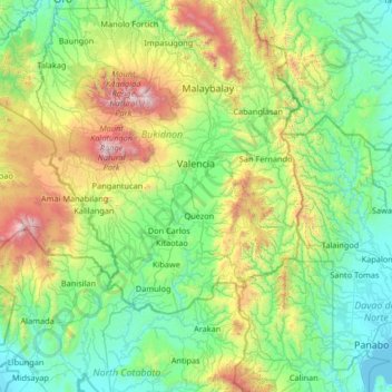
Name: Topografische Karte Pulangi River, Höhe, Relief.
Ort: Pulangi River, Bukidnon, Northern Mindanao, Philippines (7.14229 124.80235 8.44729 125.33640)
Durchschnittliche Höhe: 579 m
Minimale Höhe: 0 m
Maximale Höhe: 2.859 m
Spenden
Andere topografische Karten
Klicken Sie auf eine Karte, um ihre Topografie, ihre Höhe und ihr Relief anzuzeigen.
Malaybalay
The average elevation of the city is 622 metres (2,041 ft) above sea level. About 60% of the city's area has above 30% slope, characterized by steep hills, mountains, and cliff-like stream side. About 25% are level, gently sloping, and undulating. The rest are rolling and hilly.
Durchschnittliche Höhe: 822 m
Spenden
Lake Apo
Philippines > Bukidnon > Valencia
Lake Apo is a crater lake in Barangay Guinoyoran in the city of Valencia in Bukidnon province in the Philippines. It is located in a hilly area about 640 metres (2,100 ft) in elevation, about 11 kilometres (6.8 mi) WSW of the city poblacion (town center). Lake Apo was awarded the cleanest inland body of water…
Durchschnittliche Höhe: 643 m
Spenden
Spenden
Spenden
Valencia
Philippines > Bukidnon > Valencia
The city's topography is characterized as flat to undulating hills with extensive plateaus and mountainous areas and cliffs on both eastern and western portions bounding the municipality of San Fernando on the east and the municipality of Talakag on the west. Its highest point is Mount Kalatungan in the…
Durchschnittliche Höhe: 566 m
Spenden
Spenden
Spenden
Spenden