Geolokalisieren
👉 Easily get elevation data in JSON, GeoTIFF and KML formats using Elevation API
Vielen Dank für die Unterstützung dieser Website ❤️
Spenden

Topografische Karte Nabua

Klicken Sie auf die Karte, um die Höhe anzuzeigen.

👉 Easily get elevation data in JSON, GeoTIFF and KML formats using Elevation API
Vielen Dank für die Unterstützung dieser Website ❤️
Spenden

Nabua

Nabua has about 8,803.0600 hectares or 99.42% very low elevation or less than 100 meters elevation and remaining 51.3593 hectares or 0.58% of low elevation or between 100 and 300 meters elevation. Its slope covers about 7,927.3616 hectares or 89.53% which are level to nearly level (0-3%) while the remaining 927.0577 hectares or 10.47% are rolling to moderately steep (18-30%)

Wikipedia (CC-BY-SA 3.0)

👉 Easily get elevation data in JSON, GeoTIFF and KML formats using Elevation API
Vielen Dank für die Unterstützung dieser Website ❤️
Spenden

Über diese Karte

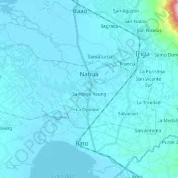
Name: Topografische Karte Nabua, Höhe, Relief.

Ort: Nabua, Camarines Sur, Bicol Region, Philippines (13.36372 123.29051 13.42938 123.42290)

Durchschnittliche Höhe: 27 m

Minimale Höhe: 2 m

Maximale Höhe: 623 m

👉 Easily get elevation data in JSON, GeoTIFF and KML formats using Elevation API
Vielen Dank für die Unterstützung dieser Website ❤️
Spenden

Andere topografische Karten

Klicken Sie auf eine Karte, um ihre Topografie, ihre Höhe und ihr Relief anzuzeigen.

Lagonoy

Philippines > Camarines Sur

Durchschnittliche Höhe: 57 m

Libmanan

Philippines > Camarines Sur

Durchschnittliche Höhe: 6 m

Panaytayan

Philippines > Camarines Sur

Durchschnittliche Höhe: 50 m

Palong

Philippines > Camarines Sur > Libmanan

Durchschnittliche Höhe: 59 m

Vielen Dank für die Unterstützung dieser Website ❤️
Spenden

Calabanga

Philippines > Camarines Sur

The topographic landscape of the municipality could be characterized as generally flat with a slope 0-3%, gently sloping (3-8%) towards the direction of the eastern portion and finally rolling up to higher steeps towards the direction of the south-eastern part going to Mt. Isarog. The 0-3% slope is a broad…

Durchschnittliche Höhe: 11 m

Santiago

Philippines > Camarines Sur

Durchschnittliche Höhe: 93 m

Maycatmon

Philippines > Camarines Sur

Durchschnittliche Höhe: 23 m

San Isidro

Philippines > Camarines Sur

Durchschnittliche Höhe: 95 m

Vielen Dank für die Unterstützung dieser Website ❤️
Spenden

Ocampo

Philippines > Camarines Sur

Durchschnittliche Höhe: 87 m

Cagas

Philippines > Camarines Sur > Nabua

Durchschnittliche Höhe: 13 m

Poloan

Philippines > Camarines Sur > Caramoan

Durchschnittliche Höhe: 132 m

San Antonio

Philippines > Camarines Sur

Durchschnittliche Höhe: 104 m

Vielen Dank für die Unterstützung dieser Website ❤️
Spenden

Curry

Philippines > Camarines Sur

Durchschnittliche Höhe: 175 m

San Jose

Philippines > Camarines Sur

Durchschnittliche Höhe: 32 m

Lupi

Philippines > Camarines Sur

Durchschnittliche Höhe: 71 m

Canaman

Philippines > Camarines Sur

Durchschnittliche Höhe: 4 m

Vielen Dank für die Unterstützung dieser Website ❤️
Spenden

Mount Asog

Philippines > Camarines Sur > Iriga

Durchschnittliche Höhe: 703 m

Gota Beach

Philippines > Camarines Sur > Caramoan > Ilawod

Durchschnittliche Höhe: 41 m

Santiago Nacacale

Philippines > Camarines Sur > Santiago Nacacale

Durchschnittliche Höhe: 118 m

Tanawan

Philippines > Camarines Sur > Tanawan

Durchschnittliche Höhe: 70 m

Vielen Dank für die Unterstützung dieser Website ❤️
Spenden

Tinago

Philippines > Camarines Sur > Naga > Tinago

Durchschnittliche Höhe: 7 m

Mount Dinoranan

Philippines > Camarines Sur > San Ramon

Durchschnittliche Höhe: 96 m