Geolokalisieren
👉 Easily get elevation data in JSON, GeoTIFF and KML formats using Elevation API
Vielen Dank für die Unterstützung dieser Website ❤️
Spenden

Topografische Karte Magpet

Klicken Sie auf die Karte, um die Höhe anzuzeigen.

👉 Easily get elevation data in JSON, GeoTIFF and KML formats using Elevation API
Vielen Dank für die Unterstützung dieser Website ❤️
Spenden

Magpet

Rice production in Magpet is only 1.16% or 1,028 hectares of the total land area with another 1.50% or 1,115 hectares as potential area due to its land topography, which is mostly hilly or mountainous.

Wikipedia (CC-BY-SA 3.0)

👉 Easily get elevation data in JSON, GeoTIFF and KML formats using Elevation API
Vielen Dank für die Unterstützung dieser Website ❤️
Spenden

Über diese Karte

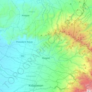
Name: Topografische Karte Magpet, Höhe, Relief.

Ort: Magpet, North Cotabato, Soccsksargen, 9404, Philippines (6.98719 125.06949 7.29940 125.31449)

Durchschnittliche Höhe: 597 m

Minimale Höhe: 58 m

Maximale Höhe: 2.923 m

👉 Easily get elevation data in JSON, GeoTIFF and KML formats using Elevation API
Vielen Dank für die Unterstützung dieser Website ❤️
Spenden

Andere topografische Karten

Klicken Sie auf eine Karte, um ihre Topografie, ihre Höhe und ihr Relief anzuzeigen.

Aleosan

Philippines > North Cotabato

Durchschnittliche Höhe: 44 m

Lika

Philippines > North Cotabato > M'lang

Durchschnittliche Höhe: 24 m

Malanduage

Philippines > North Cotabato > Kabacan

Durchschnittliche Höhe: 26 m

Nuangan

Philippines > North Cotabato > Kidapawan

Durchschnittliche Höhe: 326 m

Vielen Dank für die Unterstützung dieser Website ❤️
Spenden

Langkong

Philippines > North Cotabato > M'lang

Durchschnittliche Höhe: 29 m

Tumanding

Philippines > North Cotabato > Arakan

Durchschnittliche Höhe: 577 m

Kamada

Philippines > North Cotabato > Magpet

Durchschnittliche Höhe: 419 m

Paco

Philippines > North Cotabato > Kidapawan

Durchschnittliche Höhe: 136 m

Vielen Dank für die Unterstützung dieser Website ❤️
Spenden

Makilala

Philippines > North Cotabato > Makilala

Durchschnittliche Höhe: 253 m

Kabacan

Philippines > North Cotabato > Kabacan

Durchschnittliche Höhe: 21 m

Malabuan

Philippines > North Cotabato > Malabuan

Durchschnittliche Höhe: 188 m

Bangkal

Philippines > North Cotabato > Magpet > Bangkal

Durchschnittliche Höhe: 812 m

Vielen Dank für die Unterstützung dieser Website ❤️
Spenden