
Topografische Karte Cauayan
Klicken Sie auf die Karte, um die Höhe anzuzeigen.
Cauayan
The municipality of Cauayan has a rugged topography. Mt. Malipantao, considered the highest peak in the province, separates the municipality from the town of Candoni and the city of Sipalay. Portion of the ranges are the remaining thick forest that needs protection where the watershed is located. The remaining portions of the municipality are slightly rolling to moderate large areas of flat lands center on the different barrios, which is much suited to agriculture.
Über diese Karte
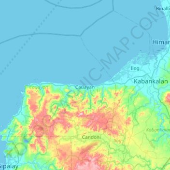
Name: Topografische Karte Cauayan, Höhe, Relief.
Durchschnittliche Höhe: 91 m
Minimale Höhe: -3 m
Maximale Höhe: 601 m
Andere topografische Karten
Klicken Sie auf eine Karte, um ihre Topografie, ihre Höhe und ihr Relief anzuzeigen.
Negros
Philippines > Negros Occidental > Himamaylan
Siquijor is an island located southeast of Negros Oriental. Area-wise, it is the third smallest in the country, with an area of 343.5 square kilometers (132.6 sq mi). Mount Malabahoc, also known as Mount Bandila‑an, is the highest point of the island, with its elevation reaching 628 meters (2,060 ft) above…
Durchschnittliche Höhe: 210 m
Mount Kanlaon
Philippines > Negros Occidental > La Castellana
Kanlaon, also known as Mount Kanlaon and Kanlaon Volcano (Hiligaynon: Bolkang Kanglaon; Cebuano: Bolkang Kanglaon; Filipino: Bulkang Kanlaon), is an active andesitic stratovolcano and the highest mountain on the island of Negros in the Philippines, as well as the highest peak in the Visayas, with an elevation…
Durchschnittliche Höhe: 1.920 m
Valley
Philippines > Negros Occidental > Don Salvador Benedicto > Igmaya-an
Durchschnittliche Höhe: 408 m
Kanlaon
Philippines > Negros Occidental > La Castellana
Kanlaon, also known as Mount Kanlaon and Kanlaon Volcano (Hiligaynon: Bolkang Kanglaon; Cebuano: Bolkang Kanglaon; Filipino: Bulkang Kanlaon), is an active andesitic stratovolcano and the highest mountain on the island of Negros in the Philippines, as well as the highest peak in the Visayas, with an elevation…
Durchschnittliche Höhe: 1.959 m
Enrique B. Magalona
Philippines > Negros Occidental > Enrique B. Magalona > Enrique B. Magalona
Durchschnittliche Höhe: 4 m