
Vielen Dank für die Unterstützung dieser Website ❤️
Spenden
Spenden
Topografische Karte Corregidor Island
Klicken Sie auf die Karte, um die Höhe anzuzeigen.
Vielen Dank für die Unterstützung dieser Website ❤️
Spenden
Spenden
Corregidor Island
The tadpole-shaped island, with its tail running eastward, is about 6.5 km (4.0 mi) long, about 2.0 km (1.2 mi) wide at its widest with a total land area of about 900 hectares (2,200 acres). The highest elevation is at 180 m (590 ft) on the Topside.[5] The island is divided into four sections.
Vielen Dank für die Unterstützung dieser Website ❤️
Spenden
Spenden
Über diese Karte
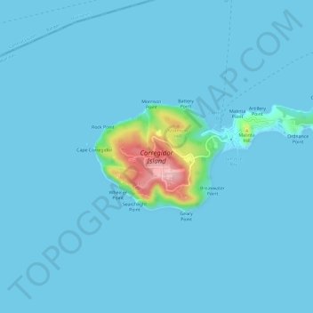
Name: Topografische Karte Corregidor Island, Höhe, Relief.
Durchschnittliche Höhe: 11 m
Minimale Höhe: -1 m
Maximale Höhe: 180 m
Vielen Dank für die Unterstützung dieser Website ❤️
Spenden
Spenden