Geolokalisieren
👉 Easily get elevation data in JSON, GeoTIFF and KML formats using Elevation API
Vielen Dank für die Unterstützung dieser Website ❤️
Spenden

Topografische Karte Baybay

Klicken Sie auf die Karte, um die Höhe anzuzeigen.

👉 Easily get elevation data in JSON, GeoTIFF and KML formats using Elevation API
Vielen Dank für die Unterstützung dieser Website ❤️
Spenden

Baybay

The climate is of Coronas Climate type IV, which is generally wet with no particularly discernible seasons. Its topography is generally mountainous in the eastern portion as it slopes down west towards the shore line. Generally an agricultural city, the common means of livelihood are farming and fishing. Some are engaged in hunting and in forestal activities. The most common crops grown are rice, corn, abaca, root crops, fruits, and vegetables. Various cottage industries can also be found in Baybay such as bamboo and rattan craft, ceramics, dress-making, fiber craft, food preservation, mat weaving, metal craft, furniture manufacture and other related activities.

Wikipedia (CC-BY-SA 3.0)

👉 Easily get elevation data in JSON, GeoTIFF and KML formats using Elevation API
Vielen Dank für die Unterstützung dieser Website ❤️
Spenden

Über diese Karte

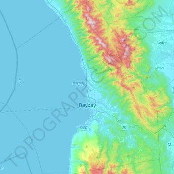
Name: Topografische Karte Baybay, Höhe, Relief.

Ort: Baybay, Leyte 5th District, Leyte, Eastern Visayas, 6521, Philippines (10.55081 124.64665 10.86925 124.93188)

Durchschnittliche Höhe: 157 m

Minimale Höhe: 0 m

Maximale Höhe: 1.137 m

👉 Easily get elevation data in JSON, GeoTIFF and KML formats using Elevation API
Vielen Dank für die Unterstützung dieser Website ❤️
Spenden

Andere topografische Karten

Klicken Sie auf eine Karte, um ihre Topografie, ihre Höhe und ihr Relief anzuzeigen.

Tacloban

Philippines > Leyte > Tacloban

Durchschnittliche Höhe: 29 m

Kabalasan

Philippines > Leyte > Baybay

Durchschnittliche Höhe: 44 m

Bulak

Philippines > Leyte > Abuyog > Bulak

Durchschnittliche Höhe: 80 m

Concepcion

Philippines > Leyte > Ormoc

Durchschnittliche Höhe: 89 m

Vielen Dank für die Unterstützung dieser Website ❤️
Spenden

Patag

Philippines > Leyte > Baybay

Durchschnittliche Höhe: 64 m

Pangasugan

Philippines > Leyte > Baybay

Durchschnittliche Höhe: 61 m

San Augustin

Philippines > Leyte > Babatngon

Durchschnittliche Höhe: 10 m

Hilaan

Philippines > Leyte > Hilongos

Durchschnittliche Höhe: 243 m

Vielen Dank für die Unterstützung dieser Website ❤️
Spenden

Manlawaan

Philippines > Leyte > Leyte

Durchschnittliche Höhe: 79 m

Mailhi

Philippines > Leyte > Baybay

Durchschnittliche Höhe: 236 m

Sea of Clouds

Philippines > Leyte > Baybay > Cuatro de Agosto

Durchschnittliche Höhe: 187 m

Divisoria

Philippines > Leyte > Alangalang > Divisoria

Durchschnittliche Höhe: 50 m

Vielen Dank für die Unterstützung dieser Website ❤️
Spenden

Mount Sacripante

Philippines > Leyte > Inopacan

Durchschnittliche Höhe: 760 m

Odiongan

Philippines > Leyte > Abuyog

Durchschnittliche Höhe: 15 m

Busay

Philippines > Leyte > Barugo > Busay

Durchschnittliche Höhe: 18 m

San Francisco East

Philippines > Leyte > Alangalang > San Francisco East

Durchschnittliche Höhe: 27 m

Vielen Dank für die Unterstützung dieser Website ❤️
Spenden

Calaguise

Philippines > Leyte > Leyte > Calaguise

Durchschnittliche Höhe: 23 m

Jubay

Philippines > Leyte > Calubian > Jubay

Durchschnittliche Höhe: 21 m

San Miguel

Philippines > Leyte > Dulag > San Miguel

Durchschnittliche Höhe: 3 m

Taglawigan

Philippines > Leyte > San Isidro > Taglawigan

Durchschnittliche Höhe: 37 m

Vielen Dank für die Unterstützung dieser Website ❤️
Spenden

Langit

Philippines > Leyte > Alangalang

Durchschnittliche Höhe: 16 m

Kalipayan

Philippines > Leyte > Burauen > Kalipayan

Durchschnittliche Höhe: 57 m