
Topografische Karte Südafrika
Interaktive Karte
Klicken Sie auf die Karte, um die Höhe anzuzeigen.
Südafrika
Südafrika hat eine große Differenzierung an klimatisch-orographischen Großeinheiten und Vegetationszonen. Sie reichen von extremer Wüste in der Kalahari an der Grenze zu Namibia bis zu subtropischen Lorbeerwäldern im Südosten und an der Grenze zu Mosambik. An der westlichen Küstenzone herrscht ein arides bis stark maritim geprägtes Klima vor. An der Südküste ist das Klima semiarid bis semihumid, was auf das Aufeinandertreffen des kalten Benguelastroms und des warmen Agulhasstroms am Kap der Guten Hoffnung zurückzuführen ist. Das Klima im Landesinneren ist voll- bis semiarid, jedoch nach Osten humider werdend, sodass das Highveld-Plateau zum Teil bereits zum immerfeuchten Ostseitenklima gerechnet werden kann. Dort gedeiht heute anthropogen entstandenes subtropisches Grasland im Osten sowie Halbwüste im Westen, die im Norden in verschiedene Savannengebiete übergeht. In Hochlagen über 1800 m NN findet sich Hochlandsteppe. Die Ostküste ist schließlich durch ein semihumides und ausgesprochen maritimes Klima gekennzeichnet. Die Region um Kapstadt weist ein mediterranes Klima auf. Schnee im Winter gibt es nur in den höheren Gebirgen.
Über diese Karte
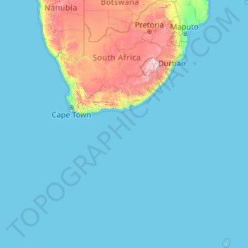
Name: Topografische Karte Südafrika, Höhe, Relief.
Ort: Südafrika (-47.17883 16.33352 -22.12503 38.28990)
Durchschnittliche Höhe: 221 m
Minimale Höhe: 0 m
Maximale Höhe: 3.367 m
Andere topografische Karten
Klicken Sie auf eine Karte, um ihre Topografie, ihre Höhe und ihr Relief anzuzeigen.
Mittelmeer
Durchschnittliche Höhe: 0 m
Afrika
Die Klimate Afrikas reichen von immerfeucht-heißem tropischem Klima bis zur kalten afroalpinen Höhenstufe auf den höchsten Gipfeln. Die nördliche Hälfte Afrikas und der äußerste Südwesten bestehen hauptsächlich aus Wüsten mit aridem Klima, während es zum Äquator hin immer humider wird. Afrika ist…
Durchschnittliche Höhe: 462 m
Butorowy Wierch
Polen > Woiwodschaft Kleinpolen > powiat tatrzański > Kościelisko
Der Butorowy Wierch ist ein Berg in den polnischen Pogórze Gubałowskie, einem Gebirgszug der Pogórze Spisko-Gubałowskie, mit 1160 Metern Höhe über Normalnull.
Durchschnittliche Höhe: 1.033 m
Raimeux de Grandval
Schweiz > Bern > Verwaltungskreis Berner Jura > Grandval
Durchschnittliche Höhe: 1.055 m
Burgeis
Italien > Trentino-Südtirol > Bozen
Burgeis (italienisch: Burgusio; rätoromanisch Barbusch) ist eine Fraktion der Gemeinde Mals in Südtirol mit 821 Einwohnern (Januar 2022). Das Dorf liegt auf 1216 m s.l.m. Höhe an der Malser Haide im Vinschgau und Vinschger Oberland, dem höchstgelegenen Abschnitt des Etschtales. Burgeis befindet sich auf…
Durchschnittliche Höhe: 1.476 m
Ernstmühl
Deutschland > Baden-Württemberg > Landkreis Calw > Calw > Hirsau
Durchschnittliche Höhe: 508 m
Sibirien
Russland > Region Krasnojarsk > Богучанский район
Dieser russische Ferne Osten (Да́льний Восто́к/Dalni Wostok) reicht von Jakutien bis zur Pazifikküste und ist mit etwa 6,18 Mio. km² Fläche größer als der Föderationskreis Sibirien. Er wird zwar außerhalb Russlands zumeist als Teil dieser Landschaft subsumiert, gilt jedoch in Russland…
Durchschnittliche Höhe: 346 m
Grand Teton
Vereinigte Staaten von Amerika > Wyoming > Teton County
Der Grand Teton ist mit einer Höhe von 4199 m der höchste Berg der Teton Range, des Grand-Teton-Nationalparks sowie des Teton County im Westen des US-Bundesstaates Wyoming. Zudem ist er nach dem Gannett Peak der zweithöchste Berg in Wyoming und der westlichste Viertausender der Rocky Mountains.
Durchschnittliche Höhe: 3.330 m
Bad Peterstal
Deutschland > Baden-Württemberg > Ortenaukreis
Bad Peterstal-Griesbach liegt auf 400 m ü. NHN bis 1000 m ü. NHN Meter Höhe im oberen Renchtal im badischen Schwarzwald.
Durchschnittliche Höhe: 553 m
Airport Village
Vereinigte Staaten von Amerika > West Virginia > Kanawha County > Charleston
Durchschnittliche Höhe: 262 m
Faulensee
Schweiz > Bern > Verwaltungskreis Frutigen-Niedersimmental > Spiez
Durchschnittliche Höhe: 638 m
Port de Pollença
Spanien > Balearische Inseln > Serra de Tramuntana
Port de Pollença wurde von den Briten schon Ende der 1920er-Jahre als Urlaubsort für gehobene Ansprüche entdeckt, eine Touristin der ersten Stunde war Agatha Christie. Bis heute stellen Briten neben Spaniern und Deutschen das größte Urlauberkontingent. Die Unterkunfts- und Grundstückspreise liegen…
Durchschnittliche Höhe: 34 m
Anchorage Bay
Neuseeland > Christchurch City > Banks Peninsula Community > Wainui
Durchschnittliche Höhe: 58 m
Grunewald
Deutschland > Nordrhein-Westfalen > Rheinisch-Bergischer Kreis > Wermelskirchen
Ortsbereich Dabringhausen: Arnzhäuschen | Bremen | Dortenhof | Emminghausen | Forthausen | Großeledder | Großfrenkhausen | Grunewald | Haussels | Heide | Höferhof | Höhe | Hundheim | Käfringhausen | Ketzberg | Ketzbergerhöhe | Kleineledder | Kleinfrenkhausen | Kleinklev | Koenenmühle | Limmringhausen |…
Durchschnittliche Höhe: 236 m
Inneraigen
Österreich > Niederösterreich > Bezirk Neunkirchen > Aspangberg-St. Peter
Durchschnittliche Höhe: 780 m
Dietersberg
Deutschland > Bayern > Landkreis Amberg-Sulzbach > Illschwang
Durchschnittliche Höhe: 449 m
Eggenhof
Deutschland > Bayern > Landkreis Erlangen-Höchstadt > Uttenreuth
Durchschnittliche Höhe: 306 m
Heisterbacherrott
Deutschland > Nordrhein-Westfalen > Rhein-Sieg-Kreis > Königswinter
Spätestens ab 1555 war Heisterbacherrott eine Honschaft im bergischen Amt Löwenburg. In der Anfang des 19. Jahrhunderts durchgeführten Topographischen Aufnahme der Rheinlande lautete der Ortsname noch Heisterbacheroth.
Durchschnittliche Höhe: 212 m
Heersum
Deutschland > Niedersachsen > Landkreis Hildesheim > Holle
Heersum liegt im Innerstebergland – knapp 12 km südöstlich des Stadtzentrums von Hildesheim. Im Tal der Innerste befindet es sich am Südhang des Höhenzugs Vorholz (243 m), nördlich dessen sich die Hildesheimer Börde erstreckt. Jenseits des die Ortschaft im Süden passierenden Flusses liegen die…
Durchschnittliche Höhe: 130 m
Bad Fredeburg
Deutschland > Nordrhein-Westfalen > Hochsauerlandkreis > Schmallenberg
Durchschnittliche Höhe: 507 m
Lantsch
Österreich > Steiermark > Bezirk Bruck-Mürzzuschlag > Breitenau am Hochlantsch > Sankt Jakob-Breitenau
Durchschnittliche Höhe: 889 m
Lima
Lima liegt am Río Rímac am Fuße der trockenen Westflanke der zentralperuanischen Anden. Nach Javier Pulgar Vidal befindet sich das Stadtzentrum in der geographischen Zone der Chala, auf rund 160 Metern über dem Meeresspiegel. Das Siedlungsgebiet der Stadtregion erstreckt sich bis in die Höhenzone der…
Durchschnittliche Höhe: 202 m
Eilvese
Deutschland > Niedersachsen > Region Hannover > Neustadt am Rübenberge
Durchschnittliche Höhe: 52 m
Juchlishaus
Schweiz > Bern > Verwaltungskreis Bern-Mittelland > Mühleberg
Durchschnittliche Höhe: 617 m
Katakolon
Griechenland > Peloponnes, Westgriechenland und Ionische Inseln > Regionalbezirk Elis > Pyrgos
Durchschnittliche Höhe: 7 m
Hagen
Deutschland > Nordrhein-Westfalen > Hagen
Der Höhenunterschied vom tiefsten Punkt an der Ruhr bei Vorhalle (86 m ü. NN) zum höchsten Punkt östlich von Bölling (438 m ü. NN) 7°33'48" E, 51°17'30" N beträgt 352 m.
Durchschnittliche Höhe: 229 m
Lantenbach
Deutschland > Nordrhein-Westfalen > Oberbergischer Kreis > Gummersbach
Durchschnittliche Höhe: 353 m
Botanischer Garten
Bereits bei der Gründung Ende des 19. Jahrhunderts lag nur etwa ein Viertel der Gartenfläche in der „Gemarkung Dahlem“. Der weit größere Teil gehörte zur „Gemarkung Groß-Lichterfelde“ (siehe Höhenplan) und zur Komplettierung der Verwirrung war er postalisch der Landgemeinde Steglitz zugeordnet.
Durchschnittliche Höhe: 52 m
Drei Zinnen
Italien > Venetien > Belluno > Auronzo di Cadore
Über den 2454 m hohen Paternsattel als tiefsten Punkt lässt sich der Zwölferkofel als nächster Gipfel erreichen, der höher als die Große Zinne ist. Damit beträgt die Schartenhöhe der Großen Zinne 545 m, die Dominanz beträgt 4,25 km.
Durchschnittliche Höhe: 2.242 m
Valongia
Italien > Trentino-Südtirol > Autonome Provinz Trient > Vigo di Fassa - Vich
Durchschnittliche Höhe: 1.610 m
Helberg
Deutschland > Nordrhein-Westfalen > Oberbergischer Kreis > Gummersbach
Durchschnittliche Höhe: 371 m
Vigo di Fassa - Vich
Italien > Trentino-Südtirol > Autonome Provinz Trient
Durchschnittliche Höhe: 1.600 m
Dobratsch
Österreich > Kärnten > Bezirk Villach-Land > Bad Bleiberg
Von Villach führt die Villacher Alpenstraße, vulgo auch Dobratschstraße, 16,5 km nach Norden bergwärts bis auf 1732 m Höhe. Die Straße ist ganzjährig tagsüber geöffnet, für Kfz in der Zeit von Mitte April bis Mitte November mautpflichtig und weist 11 Parkplätze auf. Um den Autoverkehr im Naturpark…
Durchschnittliche Höhe: 1.612 m
Pyramidenkogel
Österreich > Kärnten > Bezirk Klagenfurt-Land > Keutschach am See
Im Jahr 1950 hatte die Gemeinde Keutschach auf dem Pyramidenkogel einen 27 Meter hohen Aussichtsturm aus Holz errichten lassen. Daneben wurde im Jahr 1957 der Sender Pyramidenkogel gebaut. In den Jahren 1966 bis 1968 wurde der hölzerne Turm durch einen Aussichtsturm mit etwa 54 Meter Höhe in…
Durchschnittliche Höhe: 612 m
Plattenberg
Deutschland > Nordrhein-Westfalen > Kreis Minden-Lübbecke > Bad Oeynhausen
Durchschnittliche Höhe: 99 m
Neckeroda
Deutschland > Thüringen > Landkreis Weimarer Land > Blankenhain
Das Bauerndorf liegt 5,5 km südlich von Blankenhain auf einer mittleren Höhe von 465 m NN auf einer kupierten Hochebene. Die höchste Erhebung ist 477,7 m NN. Die Bundesstraße 85 führt im östlichen Dorfrand vorbei. In östlicher Richtung gen Wittersroda befindet sich ein unwegsames Waldgelände. In…
Durchschnittliche Höhe: 447 m
Sauerland
Deutschland > Nordrhein-Westfalen
Das Sauerland ist eine Mittelgebirgsregion in Westfalen und, je nach Definition, zum Teil auch in Hessen. Es umfasst den nordöstlichen Teil des Rheinischen Schiefergebirges. Eine genaue Abgrenzung ist nicht möglich und die Begriffsdeutung unterliegt einem stetigen Wandel. Im Kern besteht die Region aus dem…
Durchschnittliche Höhe: 316 m
West Toledo
Vereinigte Staaten von Amerika > Ohio > Lucas County > Toledo
Durchschnittliche Höhe: 186 m
Loschental
Österreich > Kärnten > Bezirk Wolfsberg > Sankt Paul im Lavanttal
Durchschnittliche Höhe: 487 m
Cuzco
Cusco (außerhalb Perus in der Regel Cuzco; auf Quechua Qusqu oder Qosqo; auf Deutsch historisch auch Kusko) ist die Hauptstadt der gleichnamigen Region und der Provinz Cusco im Zentrum des peruanischen Andenhochlandes. Sie liegt in 3416 m Höhe und hatte beim Zensus 2017 111.930 Einwohner im Stadtgebiet sowie…
Durchschnittliche Höhe: 3.790 m
Seebergsee
Schweiz > Bern > Verwaltungskreis Obersimmental-Saanen > Zweisimmen
Durchschnittliche Höhe: 1.837 m
Hausen
Deutschland > Rheinland-Pfalz > Landkreis Altenkirchen (Westerwald) > Wissen > Glatteneichen
Durchschnittliche Höhe: 229 m
Uhlstädt
Deutschland > Thüringen > Landkreis Saalfeld-Rudolstadt > Uhlstädt-Kirchhasel
Uhlstädt liegt im Norden des Gemeindegebietes im Tal der Saale. Südwestliche Nachbarortsteile sind Weißen und Etzelbach; nordöstlich schließen sich Zeutsch, Niederkrossen und Orlamünde an. Die Bundesstraße 88 und die Bahnstrecke Saalfeld–Weißenfels mit einem Haltepunkt in Uhlstädt führen durch das…
Durchschnittliche Höhe: 267 m
Wüstenbrand
Deutschland > Sachsen > Zwickau > Hohenstein-Ernstthal
Wüstenbrand befindet sich östlich von Hohenstein-Ernstthal am „Rabensteiner Höhenzug“, der den Nordrand des Erzgebirgsbeckens vom Südrand des Mittelsächsischen Lößlehm-Hügellandes trennt. Nordwestlich von Wüstenbrand befindet sich das Landschaftsschutzgebiet „Pfaffenberg–Oberwald“ mit der…
Durchschnittliche Höhe: 396 m
Piton du Canot
Mauritius > Rivière Noire / Black River > La Gaulette VCA
Durchschnittliche Höhe: 230 m
Yauri
Die auf einer Höhe von 3976 m im Andenhochland gelegene Stadt befindet sich 150 km südsüdöstlich der Regionshauptstadt Cusco, 170 km westnordwestlich vom Nordufer des Titicacasees sowie 680 km ostsüdöstlich der Landeshauptstadt Lima. Der Oberlauf des Río Apurímac verläuft 8 km westlich der Stadt in…
Durchschnittliche Höhe: 3.907 m
Comunidad Carmen Chicalulu
Bolivien > La Paz > Provincia Nor Yungas > Municipio Coroico
Durchschnittliche Höhe: 1.639 m