
Topografische Karte Maharashtra
Klicken Sie auf die Karte, um die Höhe anzuzeigen.
Maharashtra
Maharashtra with a total area of 307,713 km2 (118,809 sq mi), is the third-largest state by area in terms of land area and constitutes 9.36 per cent of India's total geographical area. The State lies between 15°35' N to 22°02' N latitude and 72°36' E to 80°54' E longitude. It occupies the western and central part of the country and has a coastline stretching 840 kilometres along the Arabian Sea. The dominant physical feature of the state is its plateau character, which is separated from the Konkan coastline by the mountain range of the Western Ghats, which runs parallel to the coast from north to south.The Western Ghats, also known as the Sahyadri Range, has an average elevation of 1,200 metres (4,000 ft); its slopes gently descending towards the east and southeast. The Western Ghats (or the Sahyadri Mountain range) provide a physical barrier to the state on the west, while the Satpura Hills along the north and Bhamragad-Chiroli-Gaikhuri ranges on the east serve as its natural borders. This state's expansion from North to South is 700 km and East to West is 800 km. To the west of these hills lie the Konkan coastal plains, 50–80 kilometres in width. To the east of the Ghats lies the flat Deccan Plateau. The main rivers of the state are the Krishna, and its tributary, Bhima, the Godavari, and its main tributaries, Manjara, and Wardha-Wainganga and the Tapi, and its tributary Purna. Maharashtra is divided into five geographic regions. Konkan is the western coastal region, between the Western Ghats and the sea. Khandesh is the north region lying in the valley of the Tapti, Purna river. Nashik, Malegaon Jalgaon, Dhule and Bhusawal are the major cities of this region. Desh is in the center of the state. Marathwada, which was a part of the princely state of Hyderabad until 1956, is located in the southeastern part of the state. Aurangabad and Nanded are the main cities of the region. Vidarbha is the easternmost region of the state, formerly part of the Central Provinces and Berar.
Über diese Karte
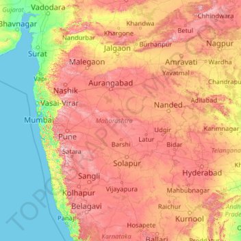
Name: Topografische Karte Maharashtra, Höhe, Relief.
Ort: Maharashtra, India (15.60636 72.65261 22.03027 80.89778)
Durchschnittliche Höhe: 346 m
Minimale Höhe: -1 m
Maximale Höhe: 1.418 m
Andere topografische Karten
Klicken Sie auf eine Karte, um ihre Topografie, ihre Höhe und ihr Relief anzuzeigen.
Surat
India > Gujarat > Katargam Taluka > Surat
Surat is a port city situated on the banks of the Tapi river. Damming of the Tapi caused the original port facilities to close; the nearest port is now in the Magadalla and Hazira area of Surat Metropolitan Region.It has famous beach called 'Dumas Beach' located in Hazira. The city is located at 21°10′N…
Durchschnittliche Höhe: 11 m
Vadodara
India > Gujarat > Vadodara Rural Taluka
Vadodara is located at 22°18′N 73°11′E / 22.30°N 73.19°E / 22.30; 73.19 in western India at an elevation of 39 metres (128 ft). It is the tenth-largest city in India with an area of 400 square kilometres (150 sq mi) and a population of 3.5 million, according to the 2010–11 census. The city…
Durchschnittliche Höhe: 36 m
Maharashtra
Maharashtra is the third largest state by area in India. The Western Ghats better known as Sahyadri, are a hilly range running parallel to the coast, at an average elevation of 1,200 metres (4,000 ft). Kalsubai, a peak in the Sahyadris, near Nashik city is the highest elevated point in Maharashtra. To the west…
Durchschnittliche Höhe: 478 m
Dehradun
India > Uttarakhand > Dehradun
The city of Dehradun mainly lies in Doon Valley and is at a varying height from 410 m (1,350 ft) in Clement Town to above 700 m (2,300 ft) at Malsi which is 15 km (9.3 mi) from the city. However, the average elevation is 450 m (1,480 ft) above sea level. Malsi is the starting point of Lesser Himalayan Range…
Durchschnittliche Höhe: 904 m
Mumbai
Mumbai lies at the mouth of the Ulhas River on the western coast of India, in the coastal region known as the Konkan. It sits on Salsette Island (Sashti Island), which it partially shares with the Thane district. Mumbai is bounded by the Arabian Sea to the west. Many parts of the city lie just above sea level,…
Durchschnittliche Höhe: 13 m
Rajsamand
India > Rajasthan > Rajsamand Tehsil
Rajsamand is located at 25°04′N 73°53′E / 25.07°N 73.88°E / 25.07; 73.88. It has an average elevation of 547 metres (1794 ft).
Durchschnittliche Höhe: 552 m
Yamuna River
The source of Yamuna lies in the Yamunotri Glacier at an elevation of 6,387 metres (20,955 ft), on the southwestern slopes of Banderpooch peaks, which lie in the Mussoorie range of the Lower Himalayas, north of Haridwar in Uttarkashi district, Uttarakhand. Yamunotri temple, a shrine dedicated to the goddess…
Durchschnittliche Höhe: 206 m
Shimla
Shimla is on the south-western ranges of the Himalayas at 31°37′N 77°06′E / 31.61°N 77.10°E / 31.61; 77.10. It has an average altitude of 2,206 metres (7,238 ft) above mean sea level and extends along a ridge with seven spurs. The city stretches nearly 9.2 kilometres (5.7 mi) from east to west.
Durchschnittliche Höhe: 1.557 m
Visakhapatnam
India > Andhra Pradesh > Visakhapatnam Urban
The city is situated between the Eastern Ghats and the Bay of Bengal. The city coordinates lies between 17.7041 N and 83.2977 E. The city's area is 682 km2. The average elevation is 45 metres. Visakhpatnam is situated in Coastal Andhra Region.
Durchschnittliche Höhe: 35 m
Bhopal
India > Madhya Pradesh > Huzur Tahsil
Bhopal has an average elevation of 500 metres (1401 ft) and is located in the central part of India, just north of the upper limit of the Vindhya mountain ranges. Located on the Malwa plateau, it is higher than the north Indian plains and the land rises towards the Vindhya Range to the south. The city has…
Durchschnittliche Höhe: 498 m
Pimpri-Chinchwad
India > Maharashtra > Haveli Subdistrict
Pimpri-Chinchwad also known as "PCMC", is a city in the Indian state of Maharashtra. The city is about 15 km (9.3 mi) northwest of the historic city of Pune, at an altitude of 590 m (1,940 ft) above sea level. It is the fifth largest city in Maharashtra and the nineteenth largest city in India and the…
Durchschnittliche Höhe: 605 m
Lucknow
India > Uttar Pradesh > Lucknow
The city stands at an elevation of approximately 123 metres (404 ft) above sea level. Lucknow city had an area of 402 km2 (155 square miles) till December 2019, when 88 villages were added to the municipal limits and the area increased to 631 km2 (244 square miles). Bounded on the east by Barabanki, on the…
Durchschnittliche Höhe: 120 m
Mangaluru
India > Karnataka > Mangaluru taluk
Mangalore is also the administrative headquarters of the Dakshina Kannada district; it is a commercial, industrial, educational, healthcare, and startup hub. The city's international airport is the second-largest and second-busiest airport in Karnataka. Mangalore City Corporation is responsible for the civic…
Durchschnittliche Höhe: 25 m
Rajkot
India > Gujarat > Rajkot East Taluka
Rajkot is located at 22°18′N 70°47′E / 22.3°N 70.78°E / 22.3; 70.78. It has an average elevation of 128 metres (420 ft). The city is located on the bank of Aji River and Nyari River which remains dry except the monsoon months of July to September. The city is spread in the area of 170.00 km².
Durchschnittliche Höhe: 141 m
Navi Mumbai
India > Maharashtra > Thane > Navi Mumbai
Navi Mumbai (Marathi pronunciation: , also known by its former name New Bombay), is a planned city off the west coast of the Indian state of Maharashtra in Konkan division. The city is divided into two parts, North Navi Mumbai and South Navi Mumbai, for the individual development of Panvel Mega City, which…
Durchschnittliche Höhe: 30 m
Guwahati
Professor Abani Kumar Bhagawati of Gauhati University stated that since before there were sufficient wetlands to absorb rainwater and channels to carry excess water to the Brahmaputra, the city did not experience floods. However, human interference has disrupted the natural topography, leading to the current…
Durchschnittliche Höhe: 113 m
Ranchi
Ranchi lies at 23°22′N 85°20′E / 23.36°N 85.33°E / 23.36; 85.33 near to the Tropic of Cancer. The city covers an area of 175 km2 (68 sq mi) and its average elevation is 651 m above sea level. Ranchi is located in the southern part of the Chota Nagpur plateau, which is the eastern section of…
Durchschnittliche Höhe: 648 m
Katwa
India > West Bengal > Katwa - I
Katwa is located at 23°39′N 88°08′E / 23.65°N 88.13°E / 23.65; 88.13. It has an average elevation of 21 m (69 ft). It is situated between the Ajay River and the Hooghly River and so is bounded by water to the east, west, and north.
Durchschnittliche Höhe: 16 m
Bilimora
India > Gujarat > Gandevi Taluka
Bilimora is located at 20°45′N 72°57′E / 20.75°N 72.95°E / 20.75; 72.95. It has an average elevation of 4 metres (13 ft). Bilimora is the second largest city in the Navsari district after Navsari city. The city is supposed to have been surrounded by three rivers: Ambika from the north, Kaveri…
Durchschnittliche Höhe: 11 m
Bargur
India > Tamil Nadu > Bargur
Bargur is spread over an area of 22.50 square kilometres (8.69 sq mi) of land in the northeast of Krishnagiri district, at 12°32′33″N 78°21′26″E / 12.5425°N 78.3572°E / 12.5425; 78.3572, at an average elevation of 532 metres (1,745 ft) above sea level. It is about 15 kilometres (9.3 mi)…
Durchschnittliche Höhe: 491 m
Mount Abu
India > Rajasthan > Abu Road Tehsil
Mount Abu town, the only hill station in Rajasthan, is at an elevation of 1,220 m (4,003 ft). It has been a popular retreat from the heat of Rajasthan and neighboring Gujarat for centuries.
Durchschnittliche Höhe: 914 m
Thiruparankundram
India > Tamil Nadu > Madurai South > Madurai > Thirupparankundram
Durchschnittliche Höhe: 145 m
Chakdaha
India > West Bengal > Chakdaha
Chakdaha is a prominent urban local body in the district of Nadia, one of the southern districts of West Bengal. Chakdaha's location is 23°05′N 88°31′E / 23.08°N 88.52°E / 23.08; 88.52. It has an average elevation of 11 meters (36 feet) and is 62 km north of the state capital, Kolkata. It is…
Durchschnittliche Höhe: 10 m
Dakshina Kannada
The topography of the district is plain up to 30 km (18.64 mi) inside the coast and changes to undulating hilly terrain sharply towards the east in the Western Ghats. Teak, bamboo and rosewood trees are found in the hilly areas towards the east. The Geological Survey of India has identified this district as a…
Durchschnittliche Höhe: 109 m
Chennai
Chennai is located on the south–eastern coast of India in the north–eastern part of Tamil Nadu on a flat coastal plain known as the Eastern Coastal Plains. Its average elevation is around 6.7 metres (22 ft), and its highest point is 60 m (200 ft). Chennai is 2,184 kilometres (1,357 mi) south of Delhi,…
Durchschnittliche Höhe: 7 m