Geolokalisieren

Topografische Karte Vadodara

Interaktive Karte

Klicken Sie auf die Karte, um die Höhe anzuzeigen.

Über diese Karte

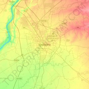
Name: Topografische Karte Vadodara, Höhe, Relief.

Ort: Vadodara, Vadodara Taluka, Vadodara District, Gujarat, 390001, India (22.13731 73.03426 22.45731 73.35426)

Durchschnittliche Höhe: 36 m

Minimale Höhe: 0 m

Maximale Höhe: 71 m

Vadodara is located at 22°18′N 73°11′E / 22.30°N 73.19°E / 22.30; 73.19 in western India at an elevation of 39 metres (128 ft). It is the tenth-largest city in India with an area of 400 square kilometres (150 sq mi) and a population of 3.5 million, according to the 2010–11 census. The city sits on the banks of the Vishwamitri River, in central Gujarat. The Vishwamitri frequently dries up in the summer, leaving only a small stream of water. The city is located on the fertile plain between the Mahi and Narmada Rivers. According to the Bureau of Indian Standards, the cosmopolis falls under seismic zone-III, on a scale of I to V (in order of increasing proneness to earthquakes).

Wikipedia (CC-BY-SA 3.0)

Andere topografische Karten

Klicken Sie auf eine Karte, um ihre Topografie, ihre Höhe und ihr Relief anzuzeigen.

Vishwamitri river

India > Gujarat > Vadodara Taluka > Vadodara

Vishwamitri river, Nava Bazaar, Vadodara, Vadodara Taluka, Vadodara District, Gujarat, 390001, India

Durchschnittliche Höhe: 38 m