
Vielen Dank für die Unterstützung dieser Website ❤️
Spenden
Spenden
Topografische Karte Chandigarh
Klicken Sie auf die Karte, um die Höhe anzuzeigen.
Vielen Dank für die Unterstützung dieser Website ❤️
Spenden
Spenden
Chandigarh
Chandigarh is located near the foothills of the Sivalik range of the Himalayas in northwest India. It covers an area of approximately 114 km2. It borders the states of Haryana and Punjab. The exact geographic co-ordinates of Chandigarh are 30°44′N 76°47′E / 30.74°N 76.79°E / 30.74; 76.79. It has an average elevation of 321 metres (1053 ft).
Vielen Dank für die Unterstützung dieser Website ❤️
Spenden
Spenden
Über diese Karte
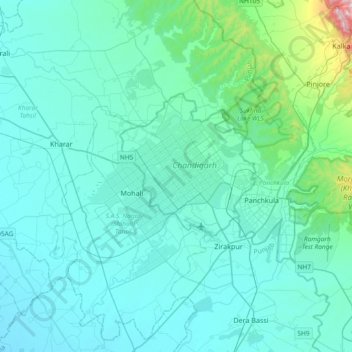
Name: Topografische Karte Chandigarh, Höhe, Relief.
Ort: Chandigarh, 160018, India (30.57344 76.61971 30.89344 76.93971)
Durchschnittliche Höhe: 378 m
Minimale Höhe: 276 m
Maximale Höhe: 1.651 m
Vielen Dank für die Unterstützung dieser Website ❤️
Spenden
Spenden