Topografische Karte Saswad
Interaktive Karte
Klicken Sie auf die Karte, um die Höhe anzuzeigen.
Über diese Karte
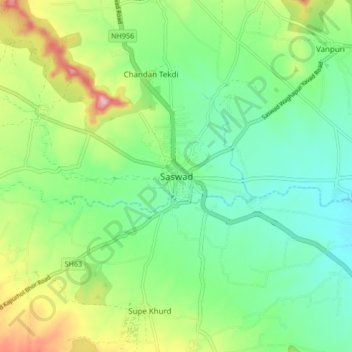
Name: Topografische Karte Saswad, Höhe, Relief.
Ort: Saswad, Purandhar, Pune, Maharashtra, 412300, India (18.30443 73.98952 18.38443 74.06952)
Durchschnittliche Höhe: 787 m
Minimale Höhe: 731 m
Maximale Höhe: 900 m
Andere topografische Karten
Klicken Sie auf eine Karte, um ihre Topografie, ihre Höhe und ihr Relief anzuzeigen.
Malhargad Fort
India > Maharashtra > Purandhar
Malhargad Fort, Malhargad Walking Path, Purandhar, Pune District, Maharashtra, India
Durchschnittliche Höhe: 822 m
Garade
India > Maharashtra > Purandhar
Garade, Purandhar, Pune, Maharashtra, 412205, India
Durchschnittliche Höhe: 883 m
Narayanpur
India > Maharashtra > Purandhar
Narayanpur, Purandhar, Maharashtra, 412302, India
Durchschnittliche Höhe: 924 m
Jejuri
India > Maharashtra > Purandhar
Jejuri, Purandhar, Pune, Maharashtra, 412303, India
Durchschnittliche Höhe: 728 m
Kalewadi
India > Maharashtra > Purandhar
Kalewadi, Purandhar, Pune, Maharashtra, India
Durchschnittliche Höhe: 839 m
Ketkawale
India > Maharashtra > Purandhar
Ketkawale, Purandhar, Pune, Maharashtra, 412302, India
Durchschnittliche Höhe: 754 m