Geolokalisieren

Topografische Karte Lucknow

Interaktive Karte

Klicken Sie auf die Karte, um die Höhe anzuzeigen.

Über diese Karte

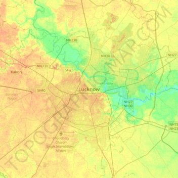
Name: Topografische Karte Lucknow, Höhe, Relief.

Ort: Lucknow, Lucknow District, Uttar Pradesh, 226027, India (26.67810 80.77460 26.99810 81.09460)

Durchschnittliche Höhe: 120 m

Minimale Höhe: 103 m

Maximale Höhe: 131 m

Lucknow stands at an elevation of approximately 123 metres (404 ft) above sea level. The city had an area of 402 km2 (155 square miles) until December 2019, when 88 villages were added to the municipal limits and the area increased to 631 km2 (244 square miles). Bounded on the east by Barabanki, on the west by Unnao, on the south by Raebareli and in the north by Sitapur and Hardoi, Lucknow sits on the northwestern shore of the Gomti River. As of 2008, there were 110 wards in the city. Morphologically, three clear demarcations exist: The Central business district, which is a fully built up area, comprises Hazratganj, Aminabad and Chowk. A middle zone surrounds the inner zone with cement houses while the outer zone consists of slums.

Wikipedia (CC-BY-SA 3.0)

Andere topografische Karten

Klicken Sie auf eine Karte, um ihre Topografie, ihre Höhe und ihr Relief anzuzeigen.

Vikram Nagar

India > Uttar Pradesh > Lucknow

Vikram Nagar, Lucknow, Lucknow District, Uttar Pradesh, 226008, India

Durchschnittliche Höhe: 124 m

Tiwariganj

India > Uttar Pradesh > Lucknow

Tiwariganj, Lucknow, Lucknow District, Uttar Pradesh, 226028, India

Durchschnittliche Höhe: 117 m

बड़ा भरवांरा

India > Uttar Pradesh > Lucknow

बड़ा भरवांरा, Lucknow, Uttar Pradesh, 227105, India

Durchschnittliche Höhe: 115 m

Gwari

India > Uttar Pradesh > Lucknow

Gwari, Lucknow, Lucknow District, Uttar Pradesh, 226010, India

Durchschnittliche Höhe: 113 m