
Spenden
Topografische Karte Thurso
Klicken Sie auf die Karte, um die Höhe anzuzeigen.
Spenden
Über diese Karte
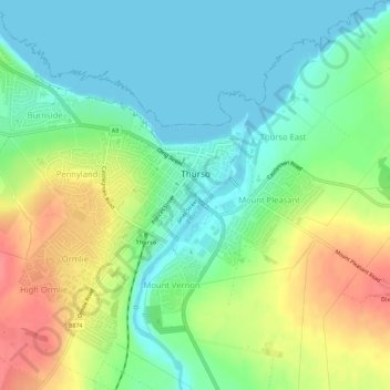
Name: Topografische Karte Thurso, Höhe, Relief.
Ort: Thurso, Highland, Scotland, United Kingdom (58.58098 -3.55606 58.60531 -3.50003)
Durchschnittliche Höhe: 25 m
Minimale Höhe: 0 m
Maximale Höhe: 68 m
Spenden
Andere topografische Karten
Klicken Sie auf eine Karte, um ihre Topografie, ihre Höhe und ihr Relief anzuzeigen.
Scottish Highlands
United Kingdom > Scotland > Highland
The Scottish Highlands are renowned for their rugged, mountainous terrain that dominates much of the region. Stretching across the northern and central parts of Scotland, the landscape is shaped by ancient geological forces, including the Caledonian Orogeny, which caused significant tectonic collisions…
Durchschnittliche Höhe: 907 m
Spenden
Spenden
Newtonmore
United Kingdom > Scotland > Highland
Newtonmore is located within the Cairngorms National Park, approximately 3 miles (5 km) southwest of Kingussie and 15 miles (24 km) southwest of Aviemore. It is on the northeastern bank of the River Spey, between the River Calder and the Allt Lairaidh, at an altitude of approximately 250 metres (820 ft).
Durchschnittliche Höhe: 283 m
Spenden
Cairn Gorm
United Kingdom > Scotland > Highland
Cairn Gorm (Scottish Gaelic: An Càrn Gorm) is a mountain in the Scottish Highlands. It is part of the Cairngorms range and wider Grampian Mountains. With a summit elevation of 1,245 m (4,085 ft) above sea level, Cairn Gorm is classed as a Munro and is the sixth-highest mountain in the British Isles. The high,…
Durchschnittliche Höhe: 989 m
Spenden
Spenden
Spenden
Spenden
Spenden