
Spenden
Topografische Karte Newtonmore
Klicken Sie auf die Karte, um die Höhe anzuzeigen.
Spenden
Newtonmore
Newtonmore is located within the Cairngorms National Park, approximately 3 miles (5 km) southwest of Kingussie and 15 miles (24 km) southwest of Aviemore. It is on the northeastern bank of the River Spey, between the River Calder and the Allt Lairaidh, at an altitude of approximately 250 metres (820 ft).
Spenden
Über diese Karte
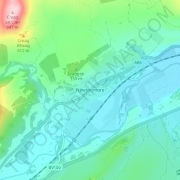
Name: Topografische Karte Newtonmore, Höhe, Relief.
Ort: Newtonmore, Highland, Scotland, PH20 1DN, United Kingdom (57.04553 -4.13936 57.08553 -4.09936)
Durchschnittliche Höhe: 283 m
Minimale Höhe: 223 m
Maximale Höhe: 536 m
Spenden
Andere topografische Karten
Klicken Sie auf eine Karte, um ihre Topografie, ihre Höhe und ihr Relief anzuzeigen.
Eilean Donan
United Kingdom > Scotland > Highland > Dornie > Totaig
In 1689, King James VII of the House of Stuart was declared to have to forfeit the throne, and the crown was offered to William of Orange, in the so-called "Glorious Revolution". The revolution also established Presbyterianism in Scotland, although the Highlands generally remained Roman Catholic and loyal to…
Durchschnittliche Höhe: 82 m
Spenden