
Vielen Dank für die Unterstützung dieser Website ❤️
Spenden
Spenden
Topografische Karte Struy
Klicken Sie auf die Karte, um die Höhe anzuzeigen.
Vielen Dank für die Unterstützung dieser Website ❤️
Spenden
Spenden
Über diese Karte
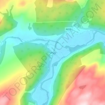
Name: Topografische Karte Struy, Höhe, Relief.
Ort: Struy, Highland, Scotland, IV4 7JS, United Kingdom (57.40159 -4.68631 57.44159 -4.64631)
Durchschnittliche Höhe: 164 m
Minimale Höhe: 44 m
Maximale Höhe: 397 m
Vielen Dank für die Unterstützung dieser Website ❤️
Spenden
Spenden
Andere topografische Karten
Klicken Sie auf eine Karte, um ihre Topografie, ihre Höhe und ihr Relief anzuzeigen.
Eilean Donan
United Kingdom > Scotland > Highland > Dornie > Totaig
In 1689, King James VII of the House of Stuart was declared to have to forfeit the throne, and the crown was offered to William of Orange, in the so-called "Glorious Revolution". The revolution also established Presbyterianism in Scotland, although the Highlands generally remained Roman Catholic and loyal to…
Durchschnittliche Höhe: 82 m
Vielen Dank für die Unterstützung dieser Website ❤️
Spenden
Spenden