
Spenden
Topografische Karte Cairn Gorm
Klicken Sie auf die Karte, um die Höhe anzuzeigen.
Spenden
Cairn Gorm
Cairn Gorm (Scottish Gaelic: An Càrn Gorm) is a mountain in the Scottish Highlands. It is part of the Cairngorms range and wider Grampian Mountains. With a summit elevation of 1,245 m (4,085 ft) above sea level, Cairn Gorm is classed as a Munro and is the sixth-highest mountain in the British Isles. The high, broad domed summit overlooking Strathspey is one of the most readily identifiable mountains from the nearby town and regional centre of Aviemore. Although it shares its name with the Cairngorm mountains, Ben Macdui is the highest mountain in the range.
Spenden
Über diese Karte
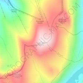
Name: Topografische Karte Cairn Gorm, Höhe, Relief.
Ort: Cairn Gorm, Highland, Scotland, PH22 1RB, United Kingdom (57.11672 -3.64454 57.11682 -3.64444)
Durchschnittliche Höhe: 989 m
Minimale Höhe: 694 m
Maximale Höhe: 1.244 m
Spenden
Andere topografische Karten
Klicken Sie auf eine Karte, um ihre Topografie, ihre Höhe und ihr Relief anzuzeigen.
Eilean Donan
United Kingdom > Scotland > Highland > Dornie > Totaig
In 1689, King James VII of the House of Stuart was declared to have to forfeit the throne, and the crown was offered to William of Orange, in the so-called "Glorious Revolution". The revolution also established Presbyterianism in Scotland, although the Highlands generally remained Roman Catholic and loyal to…
Durchschnittliche Höhe: 82 m
Spenden