
Topografische Karte Santa Eufémia
Interaktive Karte
Klicken Sie auf die Karte, um die Höhe anzuzeigen.
Über diese Karte
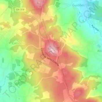
Name: Topografische Karte Santa Eufémia, Höhe, Relief.
Ort: Santa Eufémia, Trofa, Porto, 4485-266, Portugal (41.31065 -8.63060 41.31075 -8.63050)
Durchschnittliche Höhe: 139 m
Minimale Höhe: 42 m
Maximale Höhe: 236 m
Andere topografische Karten
Klicken Sie auf eine Karte, um ihre Topografie, ihre Höhe und ihr Relief anzuzeigen.
Portela
Portugal > Porto > Trofa > Coronado (São Romão e São Mamede)
Portela, Coronado (São Romão e São Mamede), Trofa, Porto, 4745-561, Portugal
Durchschnittliche Höhe: 132 m
Alvarelhos
Alvarelhos, Trofa, Porto, 4485-266, Portugal
Durchschnittliche Höhe: 124 m