
Vielen Dank für die Unterstützung dieser Website ❤️
Spenden
Spenden
Topografische Karte Guidões
Klicken Sie auf die Karte, um die Höhe anzuzeigen.
Vielen Dank für die Unterstützung dieser Website ❤️
Spenden
Spenden
Über diese Karte
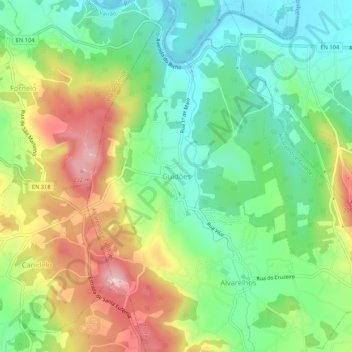
Name: Topografische Karte Guidões, Höhe, Relief.
Ort: Guidões, Trofa, Porto, 4760-564, Portugal (41.30290 -8.64091 41.34290 -8.60091)
Durchschnittliche Höhe: 103 m
Minimale Höhe: 16 m
Maximale Höhe: 236 m
Vielen Dank für die Unterstützung dieser Website ❤️
Spenden
Spenden
Andere topografische Karten
Klicken Sie auf eine Karte, um ihre Topografie, ihre Höhe und ihr Relief anzuzeigen.