Geolokalisieren

Topografische Karte Muro

Interaktive Karte

Klicken Sie auf die Karte, um die Höhe anzuzeigen.

Über diese Karte

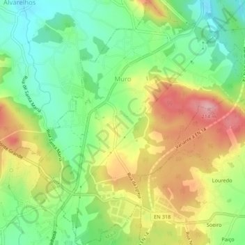
Name: Topografische Karte Muro, Höhe, Relief.

Ort: Muro, Trofa, Porto, Portugal (41.28007 -8.60832 41.31108 -8.57013)

Durchschnittliche Höhe: 129 m

Minimale Höhe: 65 m

Maximale Höhe: 213 m

Andere topografische Karten

Klicken Sie auf eine Karte, um ihre Topografie, ihre Höhe und ihr Relief anzuzeigen.

Portela

Portugal > Porto > Trofa > Coronado (São Romão e São Mamede)

Portela, Coronado (São Romão e São Mamede), Trofa, Porto, 4745-561, Portugal

Durchschnittliche Höhe: 132 m

Guidões

Portugal > Porto > Trofa

Guidões, Trofa, Porto, 4760-564, Portugal

Durchschnittliche Höhe: 103 m

Alvarelhos

Portugal > Porto > Trofa

Alvarelhos, Trofa, Porto, 4485-266, Portugal

Durchschnittliche Höhe: 124 m

Rindo

Portugal > Porto > Trofa > Covelas

Rindo, Covelas, Trofa, Porto, 4745-561, Portugal

Durchschnittliche Höhe: 123 m

Seixinho

Portugal > Porto > Trofa > Seixinho

Seixinho, Trofa, Porto, 4745-561, Portugal

Durchschnittliche Höhe: 127 m

Santa Eufémia

Portugal > Porto > Trofa

Santa Eufémia, Trofa, Porto, 4485-266, Portugal

Durchschnittliche Höhe: 139 m