
Topografische Karte Niwot
Klicken Sie auf die Karte, um die Höhe anzuzeigen.
Über diese Karte
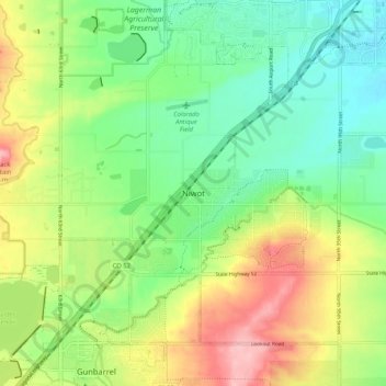
Name: Topografische Karte Niwot, Höhe, Relief.
Ort: Niwot, Boulder County, Colorado, 80544, United States (40.06387 -105.21082 40.14387 -105.13082)
Durchschnittliche Höhe: 1.570 m
Minimale Höhe: 1.517 m
Maximale Höhe: 1.654 m
Andere topografische Karten
Klicken Sie auf eine Karte, um ihre Topografie, ihre Höhe und ihr Relief anzuzeigen.
Nederland
United States > Colorado > Boulder County
In 1873 the Caribou Mine, at an elevation of roughly 10,000 feet (3,000 m) and 6 miles (10 km) northwest of the town, was sold to the Mining Company Nederland from the Netherlands. The high elevation meant fierce winds and deep winter snow, so the new owners of the mine decided that it was beneficial to bring…
Durchschnittliche Höhe: 2.578 m
University of Colorado Boulder (Williams Village)
United States > Colorado > Boulder County > Boulder
Durchschnittliche Höhe: 1.634 m
Fredrick Law Olmsted, Jr. Park
United States > Colorado > Boulder County > Boulder
Durchschnittliche Höhe: 1.664 m
Jamestown
United States > Colorado > Boulder County
Jamestown is in central Boulder County at 40°6′56″N 105°23′15″W / 40.11556°N 105.38750°W / 40.11556; -105.38750 (40.115485, −105.387531). It lies along James Creek within the Front Range of the Colorado Rockies, with access via James Canyon Drive, which leads east 8 miles (13 km) to U.S.…
Durchschnittliche Höhe: 2.271 m
National Center for Atmospheric Research
United States > Colorado > Boulder County > Boulder
Durchschnittliche Höhe: 1.816 m