
Topografische Karte Nederland
Klicken Sie auf die Karte, um die Höhe anzuzeigen.
Nederland
In 1873 the Caribou Mine, at an elevation of roughly 10,000 feet (3,000 m) and 6 miles (10 km) northwest of the town, was sold to the Mining Company Nederland from the Netherlands. The high elevation meant fierce winds and deep winter snow, so the new owners of the mine decided that it was beneficial to bring ore from Caribou down to Middle Boulder for milling. In the Dutch language, Nederland ("Netherlands" in English) means low land, and based on casual usage by the Dutch miners, Middle Boulder came to be known as Nederland. In 1874 the town was incorporated and adopted Nederland as the official name.
Über diese Karte
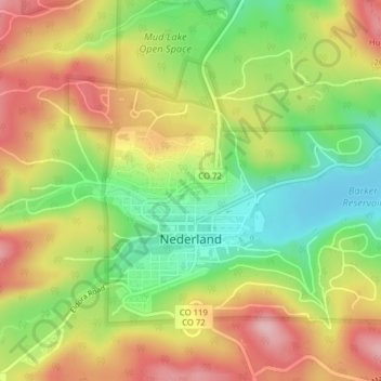
Name: Topografische Karte Nederland, Höhe, Relief.
Ort: Nederland, Boulder County, Colorado, 80466, United States (39.95498 -105.52334 39.97532 -105.48418)
Durchschnittliche Höhe: 2.578 m
Minimale Höhe: 2.482 m
Maximale Höhe: 2.677 m
Andere topografische Karten
Klicken Sie auf eine Karte, um ihre Topografie, ihre Höhe und ihr Relief anzuzeigen.
Boulder
United States > Colorado > Boulder County > Boulder
Boulder is located at the base of the foothills of the Rocky Mountains, at an elevation of 5,430 feet (1,655 m) above sea level. Boulder is 25 miles (40 km) northwest of the Colorado State Capitol in Denver. It is home of the main campus of the University of Colorado, the state's largest university.
Durchschnittliche Höhe: 1.977 m
Seven Hills
United States > Colorado > Boulder County > Boulder > Seven Hills
Durchschnittliche Höhe: 1.985 m
Lafayette
United States > Colorado > Boulder County > Lafayette > Lafayette
Durchschnittliche Höhe: 1.597 m