Geolokalisieren
👉 Easily get elevation data in JSON, GeoTIFF and KML formats using Elevation API
Vielen Dank für die Unterstützung dieser Website ❤️
Spenden

Topografische Karte Button Rock Preserve

Klicken Sie auf die Karte, um die Höhe anzuzeigen.

👉 Easily get elevation data in JSON, GeoTIFF and KML formats using Elevation API
Vielen Dank für die Unterstützung dieser Website ❤️
Spenden

Über diese Karte

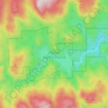
Name: Topografische Karte Button Rock Preserve, Höhe, Relief.

Ort: Button Rock Preserve, Longmont Dam Road, Boulder County, Colorado, United States (40.20673 -105.41125 40.23489 -105.33877)

Durchschnittliche Höhe: 2.139 m

Minimale Höhe: 1.838 m

Maximale Höhe: 2.545 m

👉 Easily get elevation data in JSON, GeoTIFF and KML formats using Elevation API
Vielen Dank für die Unterstützung dieser Website ❤️
Spenden

Andere topografische Karten

Klicken Sie auf eine Karte, um ihre Topografie, ihre Höhe und ihr Relief anzuzeigen.

Eldorado Canyon State Park

United States > Colorado > Boulder County

Durchschnittliche Höhe: 2.277 m

Lafayette

United States > Colorado > Boulder County > Lafayette > Lafayette

Durchschnittliche Höhe: 1.597 m

Wondervu

United States > Colorado > Boulder County

Durchschnittliche Höhe: 2.511 m

Niwot

United States > Colorado > Boulder County

Durchschnittliche Höhe: 1.570 m

Vielen Dank für die Unterstützung dieser Website ❤️
Spenden

Boulder

United States > Colorado > Boulder County > Boulder

Boulder is located at the base of the foothills of the Rocky Mountains, at an elevation of 5,430 feet (1,655 m) above sea level. Boulder is 25 miles (40 km) northwest of the Colorado State Capitol in Denver. It is home of the main campus of the University of Colorado, the state's largest university.

Durchschnittliche Höhe: 1.977 m

Rabbit Mountain

United States > Colorado > Boulder County

Durchschnittliche Höhe: 1.687 m

Seven Hills

United States > Colorado > Boulder County > Boulder > Seven Hills

Durchschnittliche Höhe: 1.985 m

Hidden Lake

United States > Colorado > Boulder County

Durchschnittliche Höhe: 2.679 m

Vielen Dank für die Unterstützung dieser Website ❤️
Spenden

Monument Hill

United States > Colorado > Boulder County

Durchschnittliche Höhe: 2.315 m

Poorman Hill

United States > Colorado > Boulder County

Durchschnittliche Höhe: 1.945 m

Peaceful Valley

United States > Colorado > Boulder County

Durchschnittliche Höhe: 2.699 m

The Flatirons

United States > Colorado > Boulder County

Durchschnittliche Höhe: 2.051 m

Vielen Dank für die Unterstützung dieser Website ❤️
Spenden

Wallstreet

United States > Colorado > Boulder County

Durchschnittliche Höhe: 2.266 m

Dominion

United States > Colorado > Boulder County > Longmont

Durchschnittliche Höhe: 1.523 m

Sunset

United States > Colorado > Boulder County > Sunset

Durchschnittliche Höhe: 2.591 m

Buckingham Campground

United States > Colorado > Boulder County

Durchschnittliche Höhe: 3.338 m

Vielen Dank für die Unterstützung dieser Website ❤️
Spenden