Geolokalisieren
👉 Easily get elevation data in JSON, GeoTIFF and KML formats using Elevation API
Vielen Dank für die Unterstützung dieser Website ❤️
Spenden

Topografische Karte Negros

Klicken Sie auf die Karte, um die Höhe anzuzeigen.

👉 Easily get elevation data in JSON, GeoTIFF and KML formats using Elevation API
Vielen Dank für die Unterstützung dieser Website ❤️
Spenden

Negros

Siquijor is an island located southeast of Negros Oriental. Area-wise, it is the third smallest in the country, with an area of 343.5 square kilometers (132.6 sq mi). Mount Malabahoc, also known as Mount Bandila‑an, is the highest point of the island, with its elevation reaching 628 meters (2,060 ft) above sea level. Marine terraces can be found in San Juan, as well as fossils of the giant clam tridacna in the island's plowed inland fields.

Wikipedia (CC-BY-SA 3.0)

👉 Easily get elevation data in JSON, GeoTIFF and KML formats using Elevation API
Vielen Dank für die Unterstützung dieser Website ❤️
Spenden

Über diese Karte

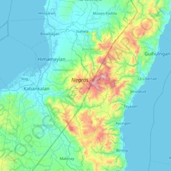
Name: Topografische Karte Negros, Höhe, Relief.

Ort: Negros, Himamaylan, Negros Occidental, Western Visayas, 6108, Philippines (9.68000 122.68000 10.32000 123.32000)

Durchschnittliche Höhe: 210 m

Minimale Höhe: -1 m

Maximale Höhe: 1.440 m

👉 Easily get elevation data in JSON, GeoTIFF and KML formats using Elevation API
Vielen Dank für die Unterstützung dieser Website ❤️
Spenden