Geolokalisieren
👉 Easily get elevation data in JSON, GeoTIFF and KML formats using Elevation API
Vielen Dank für die Unterstützung dieser Website ❤️
Spenden

Topografische Karte Oak Hill

Klicken Sie auf die Karte, um die Höhe anzuzeigen.

👉 Easily get elevation data in JSON, GeoTIFF and KML formats using Elevation API
Vielen Dank für die Unterstützung dieser Website ❤️
Spenden

Über diese Karte

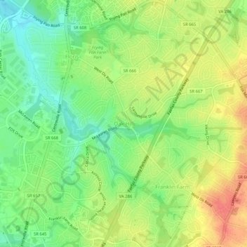
Name: Topografische Karte Oak Hill, Höhe, Relief.

Ort: Oak Hill, Fairfax County, Virginia, 20171, United States (38.90597 -77.42192 38.94597 -77.38192)

Durchschnittliche Höhe: 111 m

Minimale Höhe: 83 m

Maximale Höhe: 141 m

👉 Easily get elevation data in JSON, GeoTIFF and KML formats using Elevation API
Vielen Dank für die Unterstützung dieser Website ❤️
Spenden

Andere topografische Karten

Klicken Sie auf eine Karte, um ihre Topografie, ihre Höhe und ihr Relief anzuzeigen.

Reston

United States > Virginia > Fairfax County > Reston

Durchschnittliche Höhe: 108 m

Greenbriar

United States > Virginia > Fairfax County > Greenbriar

Durchschnittliche Höhe: 116 m

Herndon

United States > Virginia > Fairfax County

Durchschnittliche Höhe: 111 m

Vienna

United States > Virginia > Fairfax County

Durchschnittliche Höhe: 117 m

Vielen Dank für die Unterstützung dieser Website ❤️
Spenden

Belle Haven Park

United States > Virginia > Fairfax County > Alexandria

Durchschnittliche Höhe: 24 m

Difficult Run

United States > Virginia > Fairfax County > Reston

Durchschnittliche Höhe: 69 m

Hybla Valley

United States > Virginia > Fairfax County > Hybla Valley

Durchschnittliche Höhe: 20 m

Vielen Dank für die Unterstützung dieser Website ❤️
Spenden

Kings Park

United States > Virginia > Fairfax County > Kings Park

Durchschnittliche Höhe: 89 m

Huntington

United States > Virginia > Fairfax County > Huntington

Durchschnittliche Höhe: 23 m

Lorton

United States > Virginia > Fairfax County > Lorton

According to the United States Census Bureau, the Lorton CDP has a total area of 5.4 square miles (13.9 km2), of which 5.3 square miles (13.7 km2) is land and 0.1 square miles (0.2 km2), or 1.39%, is water. The elevation ranges from sea level at the Prince William County line (the Occoquan River) to slightly…

Durchschnittliche Höhe: 37 m

Vielen Dank für die Unterstützung dieser Website ❤️
Spenden

Franklin Glen Park

United States > Virginia > Fairfax County

Durchschnittliche Höhe: 108 m

Ravensworth

United States > Virginia > Fairfax County > Ravensworth

Durchschnittliche Höhe: 80 m

Vienna

United States > Virginia > Fairfax County

Vienna is located at 38°54′N 77°16′W / 38.900°N 77.267°W / 38.900; -77.267 (38.8991, −77.2607), at an elevation of 358 feet (109 meters). It lies in the Piedmont approximately 5.5 miles (8.9 km) southwest of the Potomac River. Wolftrap Creek, a tributary of nearby Difficult Run, flows north…

Durchschnittliche Höhe: 117 m

Vielen Dank für die Unterstützung dieser Website ❤️
Spenden

Hayfield

United States > Virginia > Fairfax County > Hayfield

Durchschnittliche Höhe: 28 m

Union Mill

United States > Virginia > Fairfax County > Union Mill

Durchschnittliche Höhe: 97 m

Belle Haven Park

United States > Virginia > Fairfax County > Alexandria

Durchschnittliche Höhe: 24 m

George Mason

United States > Virginia > Fairfax County > George Mason

Durchschnittliche Höhe: 126 m

Vielen Dank für die Unterstützung dieser Website ❤️
Spenden

Fort Belvoir

United States > Virginia > Fairfax County > Fort Belvoir

Durchschnittliche Höhe: 22 m

Belle Haven

United States > Virginia > Fairfax County > Belle Haven

Durchschnittliche Höhe: 23 m

Mason Neck

United States > Virginia > Fairfax County > Mason Neck

Durchschnittliche Höhe: 12 m

Vielen Dank für die Unterstützung dieser Website ❤️
Spenden

Clifton

United States > Virginia > Fairfax County

Durchschnittliche Höhe: 87 m

Merrifield

United States > Virginia > Fairfax County > Merrifield

Durchschnittliche Höhe: 110 m

Vielen Dank für die Unterstützung dieser Website ❤️
Spenden

George Mason

United States > Virginia > Fairfax County > George Mason

Durchschnittliche Höhe: 126 m

Woodlawn

United States > Virginia > Fairfax County > Woodlawn

Durchschnittliche Höhe: 14 m

Reston

United States > Virginia > Fairfax County > Reston

Durchschnittliche Höhe: 108 m

Reston

United States > Virginia > Fairfax County > Reston

Durchschnittliche Höhe: 108 m

Vielen Dank für die Unterstützung dieser Website ❤️
Spenden

Herndon

United States > Virginia > Fairfax County

Durchschnittliche Höhe: 111 m

McLean

United States > Virginia > Fairfax County > McLean

McLean is located at 38°56′03″N 77°10′39″W / 38.93417°N 77.17750°W / 38.93417; -77.17750 (38.9342776, -77.1774801) at an elevation of 285 feet (87 m). Located on the Capital Beltway (Interstate 495) in Northern Virginia, central McLean is 8 miles (13 km) northwest of downtown Washington,…

Durchschnittliche Höhe: 89 m

Burke

United States > Virginia > Fairfax County > Burke

Durchschnittliche Höhe: 96 m

Vielen Dank für die Unterstützung dieser Website ❤️
Spenden

Belle Haven

United States > Virginia > Fairfax County > Belle Haven

Durchschnittliche Höhe: 23 m

Ravensworth

United States > Virginia > Fairfax County > Ravensworth

Durchschnittliche Höhe: 80 m

Fort Belvoir

United States > Virginia > Fairfax County > Fort Belvoir

Durchschnittliche Höhe: 22 m

Burke

United States > Virginia > Fairfax County > Burke

Durchschnittliche Höhe: 96 m

Vielen Dank für die Unterstützung dieser Website ❤️
Spenden

Herndon

United States > Virginia > Fairfax County

Durchschnittliche Höhe: 111 m

Hayfield

United States > Virginia > Fairfax County > Hayfield

Durchschnittliche Höhe: 28 m

Herndon

United States > Virginia > Fairfax County

Durchschnittliche Höhe: 111 m

Springfield

United States > Virginia > Fairfax County > Springfield

Durchschnittliche Höhe: 68 m

Vielen Dank für die Unterstützung dieser Website ❤️
Spenden

Fort Hunt

United States > Virginia > Fairfax County > Fort Hunt

Durchschnittliche Höhe: 15 m

Lorton

United States > Virginia > Fairfax County

According to the United States Census Bureau, the Lorton CDP has a total area of 5.4 square miles (13.9 km2), of which 5.3 square miles (13.7 km2) is land and 0.1 square miles (0.2 km2), or 1.39%, is water. The elevation ranges from sea level at the Prince William County line (the Occoquan River) to slightly…

Durchschnittliche Höhe: 41 m

Fair Oaks

United States > Virginia > Fairfax County > Fair Oaks

Durchschnittliche Höhe: 130 m

Reston

United States > Virginia > Fairfax County > Reston

Durchschnittliche Höhe: 108 m

Vielen Dank für die Unterstützung dieser Website ❤️
Spenden

McLean

United States > Virginia > Fairfax County > McLean

McLean is located at 38°56′03″N 77°10′39″W / 38.93417°N 77.17750°W / 38.93417; -77.17750 (38.9342776, −77.1774801) at an elevation of 285 feet (87 m). Located on the Capital Beltway (Interstate 495) in Northern Virginia, central McLean is 8 miles (13 km) northwest of downtown Washington,…

Durchschnittliche Höhe: 89 m

Tysons

United States > Virginia > Fairfax County > Tysons

Tysons is located at 38°55′7″N 77°13′47″W / 38.91861°N 77.22972°W / 38.91861; -77.22972 (38.918485, −77.229833) at an elevation of 486 feet (148 m). Located in Northern Virginia at the intersection of Virginia State Route 123 and State Route 7, Tysons is 11 miles (18 km) west of downtown…

Durchschnittliche Höhe: 123 m

Mantua

United States > Virginia > Fairfax County

Durchschnittliche Höhe: 104 m

Annandale

United States > Virginia > Fairfax County > Annandale

Durchschnittliche Höhe: 94 m

Vielen Dank für die Unterstützung dieser Website ❤️
Spenden

Annandale

United States > Virginia > Fairfax County > Annandale

Durchschnittliche Höhe: 94 m

Huntington

United States > Virginia > Fairfax County > Huntington

Durchschnittliche Höhe: 23 m

West Springfield

United States > Virginia > Fairfax County

Durchschnittliche Höhe: 86 m

Vielen Dank für die Unterstützung dieser Website ❤️
Spenden

Newington

United States > Virginia > Fairfax County > Newington Forest

Durchschnittliche Höhe: 50 m

Herndon

United States > Virginia > Fairfax County

Durchschnittliche Höhe: 111 m

George Washington's Mount Vernon

United States > Virginia > Fairfax County > Mount Vernon

Visitors to Mount Vernon now see Washington's study, a room to which in the 18th century only a privileged few were granted entry. This simply furnished room has a combined bathroom, dressing room and office; the room was so private that few contemporary descriptions exist. Its walls are lined with naturally…

Durchschnittliche Höhe: 14 m

North Springfield

United States > Virginia > Fairfax County

Durchschnittliche Höhe: 83 m

Vielen Dank für die Unterstützung dieser Website ❤️
Spenden

Centreville

United States > Virginia > Fairfax County > Centreville

Durchschnittliche Höhe: 90 m

Oakton

United States > Virginia > Fairfax County > Oakton

Durchschnittliche Höhe: 109 m

Groveton

United States > Virginia > Fairfax County > Groveton

Durchschnittliche Höhe: 33 m

Centreville

United States > Virginia > Fairfax County > Centreville

Durchschnittliche Höhe: 90 m

Vielen Dank für die Unterstützung dieser Website ❤️
Spenden

Fair Lakes

United States > Virginia > Fairfax County > Fair Lakes

Durchschnittliche Höhe: 128 m

Burke

United States > Virginia > Fairfax County > Burke

Durchschnittliche Höhe: 97 m

Vielen Dank für die Unterstützung dieser Website ❤️
Spenden

Tysons

United States > Virginia > Fairfax County

Tysons is located at 38°55′7″N 77°13′47″W / 38.91861°N 77.22972°W / 38.91861; -77.22972 (38.918485, −77.229833) at an elevation of 486 feet (148 m). Located in Northern Virginia at the intersection of Virginia State Route 123 and State Route 7, Tysons is 11 miles (18 km) west of downtown…

Durchschnittliche Höhe: 122 m