Geolokalisieren

Topografische Karte Tysons

Interaktive Karte

Klicken Sie auf die Karte, um die Höhe anzuzeigen.

Über diese Karte

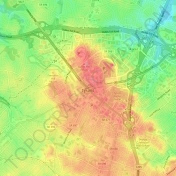
Name: Topografische Karte Tysons, Höhe, Relief.

Ort: Tysons, Fairfax County, Virginia, 22103, United States (38.90340 -77.25444 38.93496 -77.19624)

Durchschnittliche Höhe: 123 m

Minimale Höhe: 75 m

Maximale Höhe: 164 m

Tysons is located at 38°55′7″N 77°13′47″W / 38.91861°N 77.22972°W / 38.91861; -77.22972 (38.918485, −77.229833) at an elevation of 486 feet (148 m). Located in Northern Virginia at the intersection of Virginia State Route 123 and State Route 7, Tysons is 11 miles (18 km) west of downtown Washington, D.C. and 6 miles (9.7 km) northeast of Fairfax, the county seat.

Wikipedia (CC-BY-SA 3.0)

Andere topografische Karten

Klicken Sie auf eine Karte, um ihre Topografie, ihre Höhe und ihr Relief anzuzeigen.

George Mason

United States > Virginia > Fairfax County

George Mason, Fairfax County, Virginia, 22032, United States

Durchschnittliche Höhe: 123 m

West Springfield

United States > Virginia > Fairfax County

West Springfield, Fairfax County, Virginia, 22152, United States

Durchschnittliche Höhe: 86 m

North Springfield

United States > Virginia > Fairfax County

North Springfield, Fairfax County, Virginia, United States

Durchschnittliche Höhe: 83 m

Vienna

United States > Virginia > Fairfax County > Vienna

Vienna, Fairfax County, Virginia, United States

Durchschnittliche Höhe: 117 m

Fairfax Farms

United States > Virginia > Fairfax County > Fair Oaks

Fairfax Farms, Fair Oaks, Fairfax County, Virginia, 22035, United States

Durchschnittliche Höhe: 128 m

Lincoln Park

United States > Virginia > Fairfax County > Braddock

Lincoln Park, Braddock, Fairfax County, Virginia, 22035, United States

Durchschnittliche Höhe: 120 m

McLean

United States > Virginia > Fairfax County

McLean, Fairfax County, Virginia, United States

Durchschnittliche Höhe: 89 m

Herndon

United States > Virginia > Fairfax County

Herndon, Fairfax County, Virginia, 20170, United States

Durchschnittliche Höhe: 111 m

Centreville

United States > Virginia > Fairfax County

Centreville, Fairfax County, Virginia, United States

Durchschnittliche Höhe: 96 m

George Washington's Mount Vernon

United States > Virginia > Fairfax County > Mount Vernon

George Washington's Mount Vernon, Mount Vernon, Fairfax County, Virginia, 22121, United States

Durchschnittliche Höhe: 14 m

Tyler Park

United States > Virginia > Fairfax County

Tyler Park, Fairfax County, Virginia, 22042, United States

Durchschnittliche Höhe: 102 m

Lake Accotink

United States > Virginia > Fairfax County > North Springfield

Lake Accotink, North Springfield, Fairfax County, Virginia, United States

Durchschnittliche Höhe: 80 m

Bryn Mawr

United States > Virginia > Fairfax County

Bryn Mawr, Fairfax County, Virginia, 22101, United States

Durchschnittliche Höhe: 89 m

Langley Forest

United States > Virginia > Fairfax County > McLean

Langley Forest, McLean, Fairfax County, Virginia, 22101, United States

Durchschnittliche Höhe: 67 m

Fair Oaks

United States > Virginia > Fairfax County

Fair Oaks, Fairfax County, Virginia, 22035, United States

Durchschnittliche Höhe: 131 m

Mount Vernon Community Park

United States > Virginia > Fairfax County > Fort Hunt > Snowden

Mount Vernon Community Park, Wellington, Snowden, Fort Hunt, Fairfax County, Virginia, United States

Durchschnittliche Höhe: 14 m

Lee Meadows

United States > Virginia > Fairfax County

Lee Meadows, Fairfax County, Virginia, 22032, United States

Durchschnittliche Höhe: 110 m

Oak Hill

United States > Virginia > Fairfax County

Oak Hill, Fairfax County, Virginia, 20171, United States

Durchschnittliche Höhe: 111 m

Brookhaven

United States > Virginia > Fairfax County

Brookhaven, Fairfax County, Virginia, 22101, United States

Durchschnittliche Höhe: 83 m

Floris

United States > Virginia > Fairfax County

Floris, Fairfax County, Virginia, 20171, United States

Durchschnittliche Höhe: 105 m

Shirley Gate Park

United States > Virginia > Fairfax County > George Mason > Shirley Gate Park

Shirley Gate Park, George Mason, Fairfax County, Virginia, 22030, United States

Durchschnittliche Höhe: 128 m

Burke

United States > Virginia > Fairfax County > Burke

Burke, Fairfax County, Virginia, 22015, United States

Durchschnittliche Höhe: 97 m

Langley

United States > Virginia > Fairfax County > Langley

Langley, Fairfax County, Virginia, 22101, United States

Durchschnittliche Höhe: 70 m

Mason Neck National Wildlife Refuge

United States > Virginia > Fairfax County

Mason Neck National Wildlife Refuge, Kane's Creek Trail, Fairfax County, Virginia, United States

Durchschnittliche Höhe: 7 m

Reston

United States > Virginia > Fairfax County

Reston, Fairfax County, Virginia, United States

Durchschnittliche Höhe: 110 m

Hybla Valley

United States > Virginia > Fairfax County > Hybla Valley

Hybla Valley, Fairfax County, Virginia, United States

Durchschnittliche Höhe: 21 m

Pimmit Hills

United States > Virginia > Fairfax County > Pimmit Hills

Pimmit Hills, Fairfax County, Virginia, United States

Durchschnittliche Höhe: 112 m

Cooktown

United States > Virginia > Fairfax County > Herndon

Cooktown, Herndon, Fairfax County, Virginia, 20170, United States

Durchschnittliche Höhe: 105 m