Geolokalisieren
👉 Easily get elevation data in JSON, GeoTIFF and KML formats using Elevation API
Vielen Dank für die Unterstützung dieser Website ❤️
Spenden

Topografische Karte Lorton

Klicken Sie auf die Karte, um die Höhe anzuzeigen.

👉 Easily get elevation data in JSON, GeoTIFF and KML formats using Elevation API
Vielen Dank für die Unterstützung dieser Website ❤️
Spenden

Lorton

According to the United States Census Bureau, the Lorton CDP has a total area of 5.4 square miles (13.9 km2), of which 5.3 square miles (13.7 km2) is land and 0.1 square miles (0.2 km2), or 1.39%, is water. The elevation ranges from sea level at the Prince William County line (the Occoquan River) to slightly over 200 feet (61 m) along Furnace Road at the CDP's western edge.

Wikipedia (CC-BY-SA 3.0)

👉 Easily get elevation data in JSON, GeoTIFF and KML formats using Elevation API
Vielen Dank für die Unterstützung dieser Website ❤️
Spenden

Über diese Karte

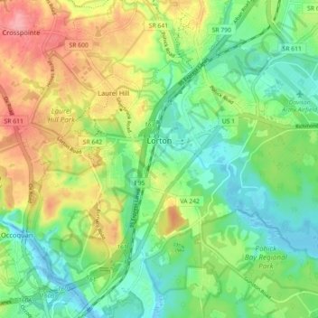
Name: Topografische Karte Lorton, Höhe, Relief.

Ort: Lorton, Fairfax County, Virginia, United States (38.66687 -77.28193 38.73371 -77.19295)

Durchschnittliche Höhe: 41 m

Minimale Höhe: -4 m

Maximale Höhe: 107 m

👉 Easily get elevation data in JSON, GeoTIFF and KML formats using Elevation API
Vielen Dank für die Unterstützung dieser Website ❤️
Spenden

Andere topografische Karten

Klicken Sie auf eine Karte, um ihre Topografie, ihre Höhe und ihr Relief anzuzeigen.

Oak Hill

United States > Virginia > Fairfax County

Durchschnittliche Höhe: 111 m

Difficult Run

United States > Virginia > Fairfax County > Reston

Durchschnittliche Höhe: 69 m

Belle Haven Park

United States > Virginia > Fairfax County > Alexandria

Durchschnittliche Höhe: 24 m

Franklin Glen Park

United States > Virginia > Fairfax County

Durchschnittliche Höhe: 108 m

Vielen Dank für die Unterstützung dieser Website ❤️
Spenden

Belle Haven Park

United States > Virginia > Fairfax County > Alexandria

Durchschnittliche Höhe: 24 m

Woodlawn

United States > Virginia > Fairfax County > Mount Vernon

Durchschnittliche Höhe: 14 m

Hutchison

United States > Virginia > Fairfax County

Durchschnittliche Höhe: 108 m

Vielen Dank für die Unterstützung dieser Website ❤️
Spenden

George Mason

United States > Virginia > Fairfax County

Durchschnittliche Höhe: 123 m

George Washington's Mount Vernon

United States > Virginia > Fairfax County > Mount Vernon

Visitors to Mount Vernon now see Washington's study, a room to which in the 18th century only a privileged few were granted entry. This simply furnished room has a combined bathroom, dressing room and office; the room was so private that few contemporary descriptions exist. Its walls are lined with naturally…

Durchschnittliche Höhe: 14 m

Lincoln Park

United States > Virginia > Fairfax County > Braddock

Durchschnittliche Höhe: 120 m

Tyler Park

United States > Virginia > Fairfax County

Durchschnittliche Höhe: 102 m

Vielen Dank für die Unterstützung dieser Website ❤️
Spenden

Fairfax Farms

United States > Virginia > Fairfax County > Fair Oaks

Durchschnittliche Höhe: 128 m

Fair Oaks

United States > Virginia > Fairfax County

Durchschnittliche Höhe: 131 m

Bryn Mawr

United States > Virginia > Fairfax County

Durchschnittliche Höhe: 89 m

Vielen Dank für die Unterstützung dieser Website ❤️
Spenden

Oak Hill

United States > Virginia > Fairfax County

Durchschnittliche Höhe: 111 m

Langley

United States > Virginia > Fairfax County > Langley

Durchschnittliche Höhe: 70 m

Floris

United States > Virginia > Fairfax County

Durchschnittliche Höhe: 105 m

Vielen Dank für die Unterstützung dieser Website ❤️
Spenden

Brookhaven

United States > Virginia > Fairfax County

Durchschnittliche Höhe: 83 m

Lee Meadows

United States > Virginia > Fairfax County

Durchschnittliche Höhe: 110 m

Langley Forest

United States > Virginia > Fairfax County > McLean

Durchschnittliche Höhe: 67 m

Vielen Dank für die Unterstützung dieser Website ❤️
Spenden