
Spenden
Topografische Karte Vienna
Klicken Sie auf die Karte, um die Höhe anzuzeigen.
Spenden
Über diese Karte
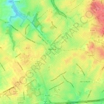
Name: Topografische Karte Vienna, Höhe, Relief.
Ort: Vienna, Fairfax County, Virginia, United States (38.87854 -77.28476 38.92182 -77.24109)
Durchschnittliche Höhe: 117 m
Minimale Höhe: 76 m
Maximale Höhe: 151 m
Spenden
Andere topografische Karten
Klicken Sie auf eine Karte, um ihre Topografie, ihre Höhe und ihr Relief anzuzeigen.
Spenden
George Washington's Mount Vernon
United States > Virginia > Fairfax County > Mount Vernon
Visitors to Mount Vernon now see Washington's study, a room to which in the 18th century only a privileged few were granted entry. This simply furnished room has a combined bathroom, dressing room and office; the room was so private that few contemporary descriptions exist. Its walls are lined with naturally…
Durchschnittliche Höhe: 14 m
Izaak Walton League of America - Arlington-Fairfax Chapter
United States > Virginia > Fairfax County > Centreville
Durchschnittliche Höhe: 72 m
Spenden
Spenden
Lake Accotink
United States > Virginia > Fairfax County > North Springfield
Durchschnittliche Höhe: 80 m
Spenden
Mount Vernon Community Park
United States > Virginia > Fairfax County > Fort Hunt > Snowden
Durchschnittliche Höhe: 14 m
Spenden
Shirley Gate Park
United States > Virginia > Fairfax County > George Mason > Shirley Gate Park
Durchschnittliche Höhe: 128 m
Spenden