
Topografische Karte Odeleite
Interaktive Karte
Klicken Sie auf die Karte, um die Höhe anzuzeigen.
Über diese Karte
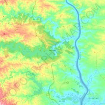
Name: Topografische Karte Odeleite, Höhe, Relief.
Ort: Odeleite, Castro Marim, Faro, Portugal (37.26714 -7.63707 37.39457 -7.43634)
Durchschnittliche Höhe: 90 m
Minimale Höhe: -2 m
Maximale Höhe: 295 m
Andere topografische Karten
Klicken Sie auf eine Karte, um ihre Topografie, ihre Höhe und ihr Relief anzuzeigen.
Praia Verde
Portugal > Faro > Castro Marim
Praia Verde, Castro Marim, Faro, Portugal
Durchschnittliche Höhe: 7 m
Alta Mora
Portugal > Faro > Castro Marim
Alta Mora, Castro Marim, Faro, Portugal
Durchschnittliche Höhe: 192 m
Azinhal
Portugal > Faro > Castro Marim
Azinhal, Castro Marim, Faro, 8950-032, Portugal
Durchschnittliche Höhe: 65 m
São Bartolomeu
Portugal > Faro > Castro Marim
São Bartolomeu, Castro Marim, Faro, 8950-256, Portugal
Durchschnittliche Höhe: 17 m
Praia do Cabeço
Portugal > Faro > Castro Marim
Praia do Cabeço, Castro Marim, Faro, Portugal
Durchschnittliche Höhe: 7 m
Praia da Alagoa
Portugal > Faro > Castro Marim
Praia da Alagoa, Altura, Castro Marim, Faro, Portugal
Durchschnittliche Höhe: 5 m