
Vielen Dank für die Unterstützung dieser Website ❤️
Spenden
Spenden
Topografische Karte Praia Verde
Klicken Sie auf die Karte, um die Höhe anzuzeigen.
Vielen Dank für die Unterstützung dieser Website ❤️
Spenden
Spenden
Über diese Karte
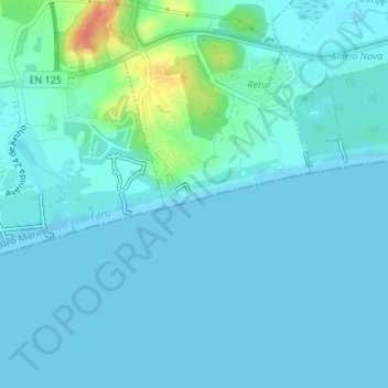
Name: Topografische Karte Praia Verde, Höhe, Relief.
Ort: Praia Verde, Castro Marim, Faro, Portugal (37.17298 -7.48210 37.17493 -7.47576)
Durchschnittliche Höhe: 7 m
Minimale Höhe: 0 m
Maximale Höhe: 49 m
Vielen Dank für die Unterstützung dieser Website ❤️
Spenden
Spenden
Andere topografische Karten
Klicken Sie auf eine Karte, um ihre Topografie, ihre Höhe und ihr Relief anzuzeigen.