
Vielen Dank für die Unterstützung dieser Website ❤️
Spenden
Spenden
Topografische Karte Alta Mora
Klicken Sie auf die Karte, um die Höhe anzuzeigen.
Vielen Dank für die Unterstützung dieser Website ❤️
Spenden
Spenden
Über diese Karte
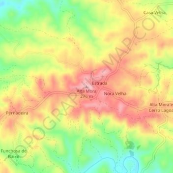
Name: Topografische Karte Alta Mora, Höhe, Relief.
Ort: Alta Mora, Castro Marim, Faro, Portugal (37.30869 -7.60687 37.30879 -7.60677)
Durchschnittliche Höhe: 192 m
Minimale Höhe: 103 m
Maximale Höhe: 267 m
Vielen Dank für die Unterstützung dieser Website ❤️
Spenden
Spenden
Andere topografische Karten
Klicken Sie auf eine Karte, um ihre Topografie, ihre Höhe und ihr Relief anzuzeigen.