
Vielen Dank für die Unterstützung dieser Website ❤️
Spenden
Spenden
Topografische Karte Azinhal
Klicken Sie auf die Karte, um die Höhe anzuzeigen.
Vielen Dank für die Unterstützung dieser Website ❤️
Spenden
Spenden
Über diese Karte
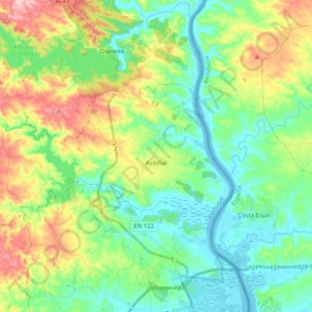
Name: Topografische Karte Azinhal, Höhe, Relief.
Ort: Azinhal, Castro Marim, Faro, 8950-032, Portugal (37.25114 -7.59505 37.32417 -7.42169)
Durchschnittliche Höhe: 65 m
Minimale Höhe: -2 m
Maximale Höhe: 206 m
Vielen Dank für die Unterstützung dieser Website ❤️
Spenden
Spenden
Andere topografische Karten
Klicken Sie auf eine Karte, um ihre Topografie, ihre Höhe und ihr Relief anzuzeigen.