
Spenden
Topografische Karte Arnprior
Klicken Sie auf die Karte, um die Höhe anzuzeigen.
Spenden
Arnprior
Arnprior is located on the Trans-Canada Highway system, where Highway 417 to the east becomes the two-lane Highway 17 to the west. The town is served by the Arnprior Airport, elevation 108 m (355 ft), and the nearby Arnprior Water Aerodrome, elevation 100 m (330 ft), for general aviation; although there is no longer commercial aviation at the airport.
Spenden
Über diese Karte
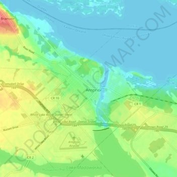
Name: Topografische Karte Arnprior, Höhe, Relief.
Ort: Arnprior, Renfrew County, Eastern Ontario, Ontario, Canada (45.40219 -76.38726 45.46592 -76.28975)
Durchschnittliche Höhe: 93 m
Minimale Höhe: 74 m
Maximale Höhe: 136 m
Spenden
Andere topografische Karten
Klicken Sie auf eine Karte, um ihre Topografie, ihre Höhe und ihr Relief anzuzeigen.
Golden Lake
Canada > Ontario > Renfrew County > North Algona Wilberforce
Durchschnittliche Höhe: 185 m
Spenden
Foymount
Canada > Ontario > Renfrew County > Bonnechere Valley
The location is also popular for amateur astronomers given the high altitude and low levels of artificial light.
Durchschnittliche Höhe: 432 m
Spenden
Palmer Rapids
Canada > Ontario > Renfrew County > Brudenell, Lyndoch and Raglan
Durchschnittliche Höhe: 319 m
Quadeville
Canada > Ontario > Renfrew County > Brudenell, Lyndoch and Raglan
Durchschnittliche Höhe: 333 m
Spenden
Bonnechere
Canada > Ontario > Renfrew County > Killaloe, Hagarty and Richards
Durchschnittliche Höhe: 174 m
Killaloe
Canada > Ontario > Renfrew County > Killaloe, Hagarty and Richards
Durchschnittliche Höhe: 182 m
Spenden
Madawaska River
Canada > Ontario > Renfrew County > Greater Madawaska > Calabogie
Durchschnittliche Höhe: 160 m
Eagles Nest Lookout
Canada > Ontario > Renfrew County > Greater Madawaska
Durchschnittliche Höhe: 246 m
Spenden
Spenden
Lorwall Lake
Canada > Ontario > Renfrew County > Brudenell, Lyndoch and Raglan
Durchschnittliche Höhe: 401 m
Spenden
Spenden
Spenden
Spenden
Spenden
Mount St. Patrick Mountains
Canada > Ontario > Renfrew County > Greater Madawaska
Durchschnittliche Höhe: 390 m
Madawaska Highlands
Canada > Ontario > Renfrew County > Killaloe, Hagarty and Richards
Durchschnittliche Höhe: 272 m
Spenden
Killaloe
Canada > Ontario > Renfrew County > Killaloe, Hagarty and Richards
Durchschnittliche Höhe: 182 m
Killaloe
Canada > Ontario > Renfrew County > Killaloe, Hagarty and Richards
Durchschnittliche Höhe: 182 m
Spenden
Spenden