
Topografische Karte Chalk River
Klicken Sie auf die Karte, um die Höhe anzuzeigen.
Über diese Karte
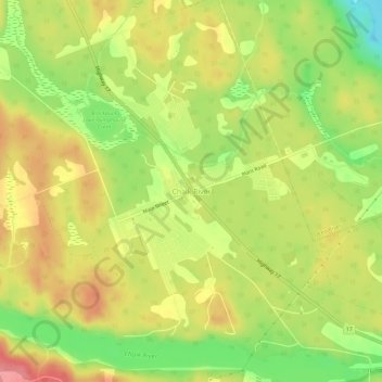
Name: Topografische Karte Chalk River, Höhe, Relief.
Durchschnittliche Höhe: 158 m
Minimale Höhe: 110 m
Maximale Höhe: 198 m
Andere topografische Karten
Klicken Sie auf eine Karte, um ihre Topografie, ihre Höhe und ihr Relief anzuzeigen.
Madawaska River
Canada > Ontario > Renfrew County > Greater Madawaska > Calabogie
Durchschnittliche Höhe: 160 m
Arnprior
Canada > Ontario > Renfrew County
Arnprior is located on the Trans-Canada Highway system, where Highway 417 to the east becomes the two-lane Highway 17 to the west. The town is served by the Arnprior Airport, elevation 108 m (355 ft), and the nearby Arnprior Water Aerodrome, elevation 100 m (330 ft), for general aviation; although there is no…
Durchschnittliche Höhe: 93 m
Bonnechere Provincial Park
Canada > Ontario > Renfrew County > Killaloe, Hagarty and Richards
Durchschnittliche Höhe: 174 m
Deep River
Canada > Ontario > Renfrew County
John Bland, an architecture professor at McGill University, developed the town's first master plan in 1944. Bland located the town between the existing Highway 17 and the Ottawa River. He designed a system of streets which generally followed the contours of the area's topography. Residential neighborhoods…
Durchschnittliche Höhe: 169 m
Golden Lake
Canada > Ontario > Renfrew County > North Algona Wilberforce > Golden Lake
Durchschnittliche Höhe: 195 m
Algonquins of Pikwàkanagàn
Canada > Ontario > Renfrew County > Golden Lake
Durchschnittliche Höhe: 190 m
Lorwall Lake
Canada > Ontario > Renfrew County > Brudenell, Lyndoch and Raglan
Durchschnittliche Höhe: 401 m
Calabogie Lake
Canada > Ontario > Renfrew County > Greater Madawaska > Calabogie
Durchschnittliche Höhe: 181 m
Raglan White Lake
Canada > Ontario > Renfrew County > Brudenell, Lyndoch and Raglan
Durchschnittliche Höhe: 324 m
Constant lake
Canada > Ontario > Renfrew County > Bonnechere Valley > Balaclava
Durchschnittliche Höhe: 203 m