Geolokalisieren
👉 Easily get elevation data in JSON, GeoTIFF and KML formats using Elevation API
Vielen Dank für die Unterstützung dieser Website ❤️
Spenden

Topografische Karte Foymount

Klicken Sie auf die Karte, um die Höhe anzuzeigen.

👉 Easily get elevation data in JSON, GeoTIFF and KML formats using Elevation API
Vielen Dank für die Unterstützung dieser Website ❤️
Spenden

Foymount

The location is also popular for amateur astronomers given the high altitude and low levels of artificial light.

Wikipedia (CC-BY-SA 3.0)

👉 Easily get elevation data in JSON, GeoTIFF and KML formats using Elevation API
Vielen Dank für die Unterstützung dieser Website ❤️
Spenden

Über diese Karte

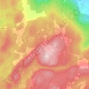
Name: Topografische Karte Foymount, Höhe, Relief.

Ort: Foymount, Bonnechere Valley, Renfrew County, Eastern Ontario, Ontario, Canada (45.41552 -77.32652 45.45552 -77.28652)

Durchschnittliche Höhe: 432 m

Minimale Höhe: 248 m

Maximale Höhe: 521 m

👉 Easily get elevation data in JSON, GeoTIFF and KML formats using Elevation API
Vielen Dank für die Unterstützung dieser Website ❤️
Spenden

Andere topografische Karten

Klicken Sie auf eine Karte, um ihre Topografie, ihre Höhe und ihr Relief anzuzeigen.

Perrault Lake

Canada > Ontario > Renfrew County > Bonnechere Valley

Durchschnittliche Höhe: 229 m

Sheedy Lake

Canada > Ontario > Renfrew County > Bonnechere Valley

Durchschnittliche Höhe: 367 m

Constant lake

Canada > Ontario > Renfrew County > Bonnechere Valley > Balaclava

Durchschnittliche Höhe: 203 m

Little Lake Clear

Canada > Ontario > Renfrew County > Bonnechere Valley

Durchschnittliche Höhe: 249 m

Vielen Dank für die Unterstützung dieser Website ❤️
Spenden

Roche Lake

Canada > Ontario > Renfrew County > Bonnechere Valley

Durchschnittliche Höhe: 257 m

Lake Clear

Canada > Ontario > Renfrew County > Bonnechere Valley

Durchschnittliche Höhe: 291 m