
Topografische Karte Častá
Interaktive Karte
Klicken Sie auf die Karte, um die Höhe anzuzeigen.
Über diese Karte
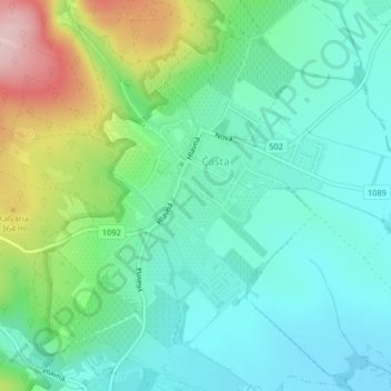
Name: Topografische Karte Častá, Höhe, Relief.
Durchschnittliche Höhe: 262 m
Minimale Höhe: 193 m
Maximale Höhe: 445 m
The village lies at an altitude of 245 meters and covers an area of 35.24 km². It has population of 2,078 people.
Andere topografische Karten
Klicken Sie auf eine Karte, um ihre Topografie, ihre Höhe und ihr Relief anzuzeigen.
Vištuk
Slovakia > Region of Bratislava > District of Pezinok
Vištuk, District of Pezinok, Region of Bratislava, 900 85, Slovakia
Durchschnittliche Höhe: 185 m
Pezinok
Slovakia > Region of Bratislava > District of Pezinok
Pezinok, District of Pezinok, Region of Bratislava, Slovakia
Durchschnittliche Höhe: 300 m
Štefanová
Slovakia > Region of Bratislava > District of Pezinok
Štefanová, District of Pezinok, Region of Bratislava, Slovakia
Durchschnittliche Höhe: 210 m