
Topografische Karte Pezinok
Interaktive Karte
Klicken Sie auf die Karte, um die Höhe anzuzeigen.
Über diese Karte
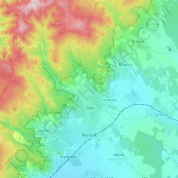
Name: Topografische Karte Pezinok, Höhe, Relief.
Ort: Pezinok, District of Pezinok, Region of Bratislava, Slovakia (48.25495 17.15309 48.38155 17.31548)
Durchschnittliche Höhe: 300 m
Minimale Höhe: 129 m
Maximale Höhe: 748 m
Pezinok lies at an altitude of 152 metres (499 ft) above sea level and covers an area of 72.555 square kilometres (28.0 sq mi).[6] It is located in the Danubian Lowland at the foothills of the Little Carpathians, around 20 km (12.43 mi) north-east of Bratislava. Another major city, Trnava, is located around 25 km (15.53 mi) to the east.
Andere topografische Karten
Klicken Sie auf eine Karte, um ihre Topografie, ihre Höhe und ihr Relief anzuzeigen.
Vištuk
Slovakia > Region of Bratislava > District of Pezinok
Vištuk, District of Pezinok, Region of Bratislava, 900 85, Slovakia
Durchschnittliche Höhe: 185 m
Častá
Slovakia > Region of Bratislava > District of Pezinok
Častá, District of Pezinok, Region of Bratislava, 900 89, Slovakia
Durchschnittliche Höhe: 262 m
Štefanová
Slovakia > Region of Bratislava > District of Pezinok
Štefanová, District of Pezinok, Region of Bratislava, Slovakia
Durchschnittliche Höhe: 210 m