
Topografische Karte Štefanová
Interaktive Karte
Klicken Sie auf die Karte, um die Höhe anzuzeigen.
Über diese Karte
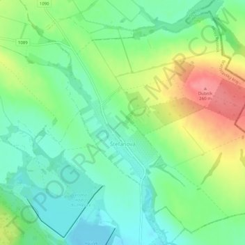
Name: Topografische Karte Štefanová, Höhe, Relief.
Ort: Štefanová, District of Pezinok, Region of Bratislava, Slovakia (48.37181 17.38137 48.40193 17.43112)
Durchschnittliche Höhe: 210 m
Minimale Höhe: 180 m
Maximale Höhe: 260 m
Andere topografische Karten
Klicken Sie auf eine Karte, um ihre Topografie, ihre Höhe und ihr Relief anzuzeigen.
Vištuk
Slovakia > Region of Bratislava > District of Pezinok
Vištuk, District of Pezinok, Region of Bratislava, 900 85, Slovakia
Durchschnittliche Höhe: 185 m
Častá
Slovakia > Region of Bratislava > District of Pezinok
Častá, District of Pezinok, Region of Bratislava, 900 89, Slovakia
Durchschnittliche Höhe: 262 m
Pezinok
Slovakia > Region of Bratislava > District of Pezinok
Pezinok, District of Pezinok, Region of Bratislava, Slovakia
Durchschnittliche Höhe: 300 m