
Spenden
Topografische Karte Les Carroz
Klicken Sie auf die Karte, um die Höhe anzuzeigen.
Spenden
Über diese Karte
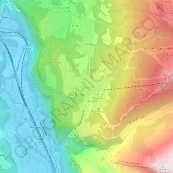
Name: Topografische Karte Les Carroz, Höhe, Relief.
Durchschnittliche Höhe: 1.073 m
Minimale Höhe: 491 m
Maximale Höhe: 1.957 m
Spenden
Andere topografische Karten
Klicken Sie auf eine Karte, um ihre Topografie, ihre Höhe und ihr Relief anzuzeigen.
Chamonix-Mont-Blanc
France > Auvergne-Rhône-Alpes > Upper Savoy
Due to its elevation, Chamonix has a humid continental climate (Dfb, according to the Köppen climate classification), with an average annual precipitation of 1,280 mm (50 in). Summers are mild and winters are cold and snowy.
Durchschnittliche Höhe: 2.215 m
Mer de Glace
France > Auvergne-Rhône-Alpes > Upper Savoy > Chamonix-Mont-Blanc
The glacier lies above the Chamonix valley. The pressure within the ice is known to reach at least 30 atmospheres. The Mer de Glace can be considered as originating at an elevation of 2,100 metres (6,900 ft), just north of the Aiguille du Tacul, where it is formed by the confluence of the Glacier de Leschaux…
Durchschnittliche Höhe: 2.323 m
Les Houches
France > Auvergne-Rhône-Alpes > Upper Savoy
Les Houches, located 6 kilometres from Chamonix, is a ski resort with a domain which extends from an altitude of 950 metres up to 1900 metres. Long descents through tree-lined slopes are combined with impressive views of the Mont Blanc massif and the Chamonix valley.
Durchschnittliche Höhe: 1.728 m
Mer de Glace
France > Auvergne-Rhône-Alpes > Upper Savoy > Chamonix-Mont-Blanc
The glacier lies above the Chamonix valley. The pressure within the ice is known to reach at least 30 atmospheres. The Mer de Glace can be considered as originating at an elevation of 2,100 metres (6,900 ft), just north of the Aiguille du Tacul [fr], where it is formed by the confluence of the Glacier de…
Durchschnittliche Höhe: 2.322 m
Spenden
Chamonix-Mont-Blanc
France > Auvergne-Rhône-Alpes > Upper Savoy
Due to its elevation, Chamonix has a humid continental climate (Dfb, according to the Köppen climate classification), with an average annual precipitation of 1,280 mm (50 in). Summers are mild and winters are cold and snowy.
Durchschnittliche Höhe: 2.215 m
Réserve naturelle des Aiguilles rouges
France > Auvergne-Rhône-Alpes > Upper Savoy > Chamonix-Mont-Blanc
Durchschnittliche Höhe: 1.951 m
Spenden
Morzine
France > Auvergne-Rhône-Alpes > Upper Savoy
A traditional market town in the heart of the Portes du Soleil, Morzine is dominated by chalets spread across a river gorge, bordered by partially wooded slopes allowing skiing in poor weather conditions. Situated at an altitude of 1000 m, it is one of the most northerly of the French Alpine resorts, and…
Durchschnittliche Höhe: 1.395 m
Saint-Gervais-les-Bains
France > Auvergne-Rhône-Alpes > Upper Savoy
The main railway station for Saint-Gervais is the Gare de Saint-Gervais-les-Bains-Le Fayet. The Mont Blanc Tramway departs from the forecourt of Le Fayet station and reaches the Nid d'Aigle station at the Bionnassay glacier at an altitude of 2,372 m (7,782 ft). The Saint-Gervais–Vallorcine railway, a metre…
Durchschnittliche Höhe: 1.589 m
Spenden
Annecy
France > Auvergne-Rhône-Alpes > Upper Savoy
Annecy has an oceanic climate (Köppen: Cfb) despite its relatively far inland position. Influenced by its elevation, summers are rather moderate on average, although they can be highly variable with extreme heat spikes. Winters see occasional freezing temperatures, but temperatures most often stay in the…
Durchschnittliche Höhe: 610 m
Sallanches
France > Auvergne-Rhône-Alpes > Upper Savoy
In 2015 Sallanches hospital announced that, as part of the government's "groupements hospitaliers de territoire" policy, it would develop a specialist accident department to research and develop mountain-related emergency medicine, because of its proximity to, and past experience of, dealing with accidents…
Durchschnittliche Höhe: 1.295 m
Glacier des Bossons
France > Auvergne-Rhône-Alpes > Upper Savoy > Chamonix-Mont-Blanc
In 1900 the snout of the glacier was still reaching down into the valley bottom at an altitude of 1,050 metres above sea level. By 1980 the snout only reached down to about 1,200 metres, and by 2008 it had melted backwards even further backwards, ended at around 1,400 metres, albeit still well below the…
Durchschnittliche Höhe: 3.138 m
Spenden
Annecy
France > Auvergne-Rhône-Alpes > Upper Savoy
Annecy has an oceanic climate (Köppen: Cfb) despite its relatively far inland position. Influenced by its elevation, summers are rather moderate on average, although they can be highly variable with extreme heat spikes. Winters see occasional freezing temperatures, but temperatures most often stay in the…
Durchschnittliche Höhe: 610 m
Spenden
Lac Blanc
France > Auvergne-Rhône-Alpes > Upper Savoy > Chamonix-Mont-Blanc
Durchschnittliche Höhe: 2.350 m
Spenden
Spenden
Chamonix-Mont-Blanc
France > Auvergne-Rhône-Alpes > Upper Savoy
Due to its elevation, Chamonix has a humid continental climate (Dfb, according to the Köppen climate classification), with an average annual precipitation of 1,280 mm (50 in). Summers are mild and winters are cold and snowy.
Durchschnittliche Höhe: 2.215 m
Les Houches
France > Auvergne-Rhône-Alpes > Upper Savoy
Les Houches, located 6 kilometres from Chamonix, is a ski resort with a domain which extends from an altitude of 950 metres up to 1900 metres. Long descents through tree-lined slopes are combined with impressive views of the Mont Blanc massif and the Chamonix valley.
Durchschnittliche Höhe: 1.728 m
Chamonix-Mont-Blanc
France > Auvergne-Rhône-Alpes > Upper Savoy
Due to its elevation, Chamonix has a humid continental climate (Dfb, according to the Köppen climate classification), with an average annual precipitation of 1,280 mm (50 in). Summers are mild and winters are cold and snowy.
Durchschnittliche Höhe: 2.215 m
Spenden
Mieussy
France > Auvergne-Rhône-Alpes > Upper Savoy
Mieussy has its own high-altitude ski resort, Sommand, starting at 1,500 metres (4,900 ft) and with 60 kilometres (37 mi) of downhill runs suitable for all levels. This is integrated over and around the surrounding mountains to the neighboring ski resort of Praz de Lys.
Durchschnittliche Höhe: 1.118 m
Chamonix-Mont-Blanc
France > Auvergne-Rhône-Alpes > Upper Savoy
Due to its elevation, Chamonix has a humid continental climate (Dfb, according to the Köppen climate classification), with an average annual precipitation of 1,280 mm (50 in). Summers are mild and winters are cold and snowy.
Durchschnittliche Höhe: 2.215 m
Morzine
France > Auvergne-Rhône-Alpes > Upper Savoy
A traditional market town in the heart of the Portes du Soleil, Morzine is dominated by chalets spread across a river gorge, bordered by partially wooded slopes allowing skiing in poor weather conditions. Situated at an altitude of about 1,000 m, it is one of the most northerly of the French Alpine resorts,…
Durchschnittliche Höhe: 1.395 m
Spenden
Spenden
Mieussy
France > Auvergne-Rhône-Alpes > Upper Savoy
Mieussy has its own high-altitude ski resort, Sommand, starting at 1,500 metres (4,900 ft) and with 60 kilometres (37 mi) of downhill runs suitable for all levels. This is integrated over and around the surrounding mountains to the neighboring ski resort of Praz de Lys.
Durchschnittliche Höhe: 1.118 m
Spenden
Saint-Jean-d'Aulps
France > Auvergne-Rhône-Alpes > Upper Savoy
The inhabitants are called (in French) the "Jovanétiens". The commune is spread over 40.2 km2 (15.5 sq mi) and has 1,558 inhabitants (2019), 6,900 beds for tourists, 464 main residences, and 1,358 secondary residences. The population density is 39 inhabitants/km2 (2019). Saint-Jean-d'Aulps is surrounded by…
Durchschnittliche Höhe: 1.316 m
Annecy
France > Auvergne-Rhône-Alpes > Upper Savoy
Annecy has an oceanic climate (Köppen: Cfb) in spite of its relatively far inland position. Influenced by its elevation, summers are rather moderate on average, although they can be highly variable with extreme heat spikes. Winters see occasional freezing temperatures, but most often stays in the…
Durchschnittliche Höhe: 610 m
Spenden
Talloires
France > Auvergne-Rhône-Alpes > Upper Savoy > Talloires-Montmin
Durchschnittliche Höhe: 1.044 m
Spenden
Spenden
Faverges
France > Auvergne-Rhône-Alpes > Upper Savoy > Faverges-Seythenex
Durchschnittliche Höhe: 854 m
Spenden
Sixt-Fer-à-Cheval
France > Auvergne-Rhône-Alpes > Upper Savoy
The area of the town ranges in altitude from 728 to 3,098 metres (2,388 to 10,164 ft); three-quarters of its area (9,200 hectares out of 11,200 total) are part of a natural reserve and completely uninhabited.
Durchschnittliche Höhe: 1.776 m
Spenden
Saint-Gervais-les-Bains
France > Auvergne-Rhône-Alpes > Upper Savoy
The main railway station for Saint-Gervais is the Gare de Saint-Gervais-les-Bains-Le Fayet. The Mont Blanc Tramway departs from the forecourt of Le Fayet station and reaches the Nid d'Aigle station at the Bionnassay glacier at an altitude of 2,372 m (7,782 ft). The Saint-Gervais–Vallorcine railway, a metre…
Durchschnittliche Höhe: 1.589 m
Spenden
Sixt-Fer-à-Cheval
France > Auvergne-Rhône-Alpes > Upper Savoy
The area of the town ranges in altitude from 728 to 3,098 metres (2,388 to 10,164 ft); three-quarters of its area (9,200 hectares out of 11,200 total) are part of a natural reserve and completely uninhabited.
Durchschnittliche Höhe: 1.776 m
Spenden
Chamonix-Mont-Blanc
France > Auvergne-Rhône-Alpes > Upper Savoy
Due to its elevation, Chamonix has a humid continental climate (Dfb, according to the Köppen climate classification), with an average annual precipitation of 1,280 mm (50 in). Summers are mild and winters are cold and snowy.
Durchschnittliche Höhe: 2.215 m
Spenden
Annecy
France > Auvergne-Rhône-Alpes > Upper Savoy
Annecy has an oceanic climate (Köppen: Cfb) despite its relatively far inland position. Influenced by its elevation, summers are rather moderate on average, although they can be highly variable with extreme heat spikes. Winters see occasional freezing temperatures, but temperatures most often stay in the…
Durchschnittliche Höhe: 610 m
Spenden
Spenden
Spenden
Seythenex
France > Auvergne-Rhône-Alpes > Upper Savoy > Faverges-Seythenex
Durchschnittliche Höhe: 1.154 m
Spenden