
Spenden
Topografische Karte Annemasse
Klicken Sie auf die Karte, um die Höhe anzuzeigen.
Spenden
Über diese Karte
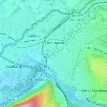
Name: Topografische Karte Annemasse, Höhe, Relief.
Durchschnittliche Höhe: 451 m
Minimale Höhe: 393 m
Maximale Höhe: 801 m
Spenden
Andere topografische Karten
Klicken Sie auf eine Karte, um ihre Topografie, ihre Höhe und ihr Relief anzuzeigen.
Mer de Glace
France > Auvergne-Rhône-Alpes > Upper Savoy > Chamonix-Mont-Blanc
The glacier lies above the Chamonix valley. The pressure within the ice is known to reach at least 30 atmospheres. The Mer de Glace can be considered as originating at an elevation of 2,100 metres (6,900 ft), just north of the Aiguille du Tacul, where it is formed by the confluence of the Glacier de Leschaux…
Durchschnittliche Höhe: 2.323 m
Argentière
France > Auvergne-Rhône-Alpes > Upper Savoy > Chamonix-Mont-Blanc
Argentière (French pronunciation: [aʁʒɑ̃tjɛʁ]) is a picturesque skiing, alpine walking and mountaineering village in the French Alps, part of the commune of Chamonix-Mont-Blanc, at an altitude of 1,252 m (4,108 ft).
Durchschnittliche Höhe: 1.674 m
Mont Blanc / Monte Bianco
France > Auvergne-Rhône-Alpes > Upper Savoy > Saint-Gervais-les-Bains
The climate is cold and temperate (Köppen climate classification Cfb), and is greatly influenced by altitude. Being the highest part of the Alps, Mont Blanc and surrounding mountains can create their own weather patterns. Temperatures drop as the mountains gain in height, and the summit of Mont Blanc is a…
Durchschnittliche Höhe: 4.092 m
Mer de Glace
France > Auvergne-Rhône-Alpes > Upper Savoy > Chamonix-Mont-Blanc
The glacier lies above the Chamonix valley. The pressure within the ice is known to reach at least 30 atmospheres. The Mer de Glace can be considered as originating at an elevation of 2,100 metres (6,900 ft), just north of the Aiguille du Tacul [fr], where it is formed by the confluence of the Glacier de…
Durchschnittliche Höhe: 2.322 m
Spenden
Les Frasserands
France > Auvergne-Rhône-Alpes > Upper Savoy > Chamonix-Mont-Blanc > Argentière
Durchschnittliche Höhe: 1.704 m
Mont Blanc / Monte Bianco
France > Auvergne-Rhône-Alpes > Upper Savoy > Saint-Gervais-les-Bains
The climate is cold and temperate (Köppen climate classification Cfb), and is greatly influenced by altitude. Being the highest part of the Alps, Mont Blanc and surrounding mountains can create their own weather patterns. Temperatures drop as the mountains gain in height, and the summit of Mont Blanc is a…
Durchschnittliche Höhe: 4.092 m
Spenden
Mont Blanc / Monte Bianco
France > Auvergne-Rhône-Alpes > Upper Savoy > Saint-Gervais-les-Bains
The climate is cold and temperate (Köppen climate classification Cfb), and is greatly influenced by altitude. Being the highest part of the Alps, Mont Blanc and surrounding mountains can create their own weather patterns. Temperatures drop as the mountains gain in height, and the summit of Mont Blanc is a…
Durchschnittliche Höhe: 4.092 m
Essert-la-Pierre
France > Auvergne-Rhône-Alpes > Upper Savoy > Saint-Jean-d'Aulps
Durchschnittliche Höhe: 1.195 m
Flaine
France > Auvergne-Rhône-Alpes > Upper Savoy
The site is divided into two areas which are joined by two free lifts. The upper area, Flaine Forêt, at an altitude of 1700 m, consists of a number of apartment buildings named after constellations, the Éric et Sylvie Boissonnas Auditorium, shops, offices and restaurants. The lower area, Flaine Forum, at an…
Durchschnittliche Höhe: 1.850 m
Spenden
Flaine
France > Auvergne-Rhône-Alpes > Upper Savoy
The site is divided into two areas which are joined by two free lifts. The upper area, Flaine Forêt, at an altitude of 1700 m, consists of a number of apartment buildings named after constellations, the Éric et Sylvie Boissonnas Auditorium, shops, offices and restaurants. The lower area, Flaine Forum, at an…
Durchschnittliche Höhe: 1.850 m
La Tournette
France > Auvergne-Rhône-Alpes > Upper Savoy > Talloires-Montmin
Durchschnittliche Höhe: 1.750 m
Mont Blanc / Monte Bianco
France > Auvergne-Rhône-Alpes > Upper Savoy > Saint-Gervais-les-Bains
The climate is cold and temperate (Köppen climate classification Cfb), and is greatly influenced by altitude. Being the highest part of the Alps, Mont Blanc and surrounding mountains can create their own weather patterns. Temperatures drop as the mountains gain in height, and the summit of Mont Blanc is a…
Durchschnittliche Höhe: 4.092 m
Spenden
Mont Blanc / Monte Bianco
France > Auvergne-Rhône-Alpes > Upper Savoy > Saint-Gervais-les-Bains
The climate is cold and temperate (Köppen climate classification Cfb), and is greatly influenced by altitude. Being the highest part of the Alps, Mont Blanc and surrounding mountains can create their own weather patterns. Temperatures drop as the mountains gain in height, and the summit of Mont Blanc is a…
Durchschnittliche Höhe: 4.092 m
Le Plan de l'Envers
France > Auvergne-Rhône-Alpes > Upper Savoy > Vallorcine
Durchschnittliche Höhe: 1.721 m
Bionnay
France > Auvergne-Rhône-Alpes > Upper Savoy > Saint-Gervais-les-Bains
Durchschnittliche Höhe: 1.276 m
Spenden
Les Granges
France > Auvergne-Rhône-Alpes > Upper Savoy > Chamonix-Mont-Blanc > Les Bossons
Durchschnittliche Höhe: 1.363 m
Aiguille du Midi
France > Auvergne-Rhône-Alpes > Upper Savoy > Chamonix-Mont-Blanc
The span of the second section is 2,867 m (1.781 mi) measured directly, but only 2,500 m (1.6 mi) measured horizontally. Thus it remains the second longest span width, measured directly. The cable car travels from Chamonix to the top of the Aiguille du Midi – an altitude gain of over 2,800 m (9,200 ft) –…
Durchschnittliche Höhe: 3.098 m
Spenden
Le Tour
France > Auvergne-Rhône-Alpes > Upper Savoy > Chamonix-Mont-Blanc
Durchschnittliche Höhe: 1.811 m
Spenden
Les Aravis d'en Bas
France > Auvergne-Rhône-Alpes > Upper Savoy > La Clusaz
Durchschnittliche Höhe: 1.649 m
Grand Jean
France > Auvergne-Rhône-Alpes > Upper Savoy > Annecy > Vieugy
Durchschnittliche Höhe: 646 m
Spenden
Quincy
France > Auvergne-Rhône-Alpes > Upper Savoy > Clarafond-Arcine > Clarafond
Durchschnittliche Höhe: 536 m
Bas-Monthoux
France > Auvergne-Rhône-Alpes > Upper Savoy > Vétraz-Monthoux
Durchschnittliche Höhe: 483 m
Spenden
Les Frasserands
France > Auvergne-Rhône-Alpes > Upper Savoy > Chamonix-Mont-Blanc > Argentière
Durchschnittliche Höhe: 1.704 m
Le Tour
France > Auvergne-Rhône-Alpes > Upper Savoy > Chamonix-Mont-Blanc
Durchschnittliche Höhe: 1.811 m
Mont Joly
France > Auvergne-Rhône-Alpes > Upper Savoy > Saint-Gervais-les-Bains
Durchschnittliche Höhe: 1.978 m
Spenden
Le Carillon
France > Auvergne-Rhône-Alpes > Upper Savoy > Annecy > Cran-Gevrier
Durchschnittliche Höhe: 501 m
Grande Rocheuse
France > Auvergne-Rhône-Alpes > Upper Savoy > Chamonix-Mont-Blanc
Durchschnittliche Höhe: 3.245 m
Spenden
Cupelin
France > Auvergne-Rhône-Alpes > Upper Savoy > Saint-Gervais-les-Bains
Durchschnittliche Höhe: 937 m
Mont Blanc / Monte Bianco
France > Auvergne-Rhône-Alpes > Upper Savoy > Saint-Gervais-les-Bains
The climate is cold and temperate (Köppen climate classification Cfb), and is greatly influenced by altitude. Being the highest part of the Alps, Mont Blanc and surrounding mountains can create their own weather patterns. Temperatures drop as the mountains gain in height, and the summit of Mont Blanc is a…
Durchschnittliche Höhe: 4.092 m
Spenden
Saint-Nicolas-de-Véroce
France > Auvergne-Rhône-Alpes > Upper Savoy > Saint-Gervais-les-Bains
Durchschnittliche Höhe: 1.340 m
Montenvers
France > Auvergne-Rhône-Alpes > Upper Savoy > Chamonix-Mont-Blanc
Durchschnittliche Höhe: 1.801 m
Spenden
Vers le Nant
France > Auvergne-Rhône-Alpes > Upper Savoy > Chamonix-Mont-Blanc > Les Bossons
Durchschnittliche Höhe: 1.357 m
Les Plans
France > Auvergne-Rhône-Alpes > Upper Savoy > Chamonix-Mont-Blanc
Durchschnittliche Höhe: 1.416 m
Spenden
Le Déjeuner
France > Auvergne-Rhône-Alpes > Upper Savoy > Essert-Romand
Durchschnittliche Höhe: 1.146 m
Aiguille de Toula
France > Auvergne-Rhône-Alpes > Upper Savoy > Chamonix-Mont-Blanc
Durchschnittliche Höhe: 3.192 m
Mont Joly
France > Auvergne-Rhône-Alpes > Upper Savoy > Saint-Gervais-les-Bains
Durchschnittliche Höhe: 1.978 m
Spenden
L'Encrenaz
France > Auvergne-Rhône-Alpes > Upper Savoy > La Côte-d'Arbroz
Durchschnittliche Höhe: 1.496 m
Spenden
Les Vercheres
France > Auvergne-Rhône-Alpes > Upper Savoy > Ville-la-Grand
Durchschnittliche Höhe: 462 m
Spenden
Aiguille du Plan
France > Auvergne-Rhône-Alpes > Upper Savoy > Chamonix-Mont-Blanc
Durchschnittliche Höhe: 2.955 m
Spenden
Aiguille du Tacul
France > Auvergne-Rhône-Alpes > Upper Savoy > Chamonix-Mont-Blanc
Durchschnittliche Höhe: 2.782 m
La Côte des Chavants
France > Auvergne-Rhône-Alpes > Upper Savoy > Les Houches
Durchschnittliche Höhe: 1.339 m
Les Canevières
France > Auvergne-Rhône-Alpes > Upper Savoy > Abondance
Durchschnittliche Höhe: 1.256 m
Spenden
La Demi-Lune
France > Auvergne-Rhône-Alpes > Upper Savoy > Demi-Quartier
Durchschnittliche Höhe: 1.219 m
Col des Aravis
France > Auvergne-Rhône-Alpes > Upper Savoy > La Clusaz
Durchschnittliche Höhe: 1.667 m
Spenden
Le Crot aux Chiens
France > Auvergne-Rhône-Alpes > Upper Savoy > Avoriaz
Durchschnittliche Höhe: 1.742 m
Ternier
France > Auvergne-Rhône-Alpes > Upper Savoy > Saint-Julien-en-Genevois
Durchschnittliche Höhe: 481 m
Spenden
Chamonix-Mont-Blanc
France > Auvergne-Rhône-Alpes > Upper Savoy > Chamonix-Mont-Blanc > Chamonix-Mont-Blanc
Durchschnittliche Höhe: 1.787 m
Spenden
Crêt de Pézollet
France > Auvergne-Rhône-Alpes > Upper Savoy > La Balme-de-Thuy
Durchschnittliche Höhe: 1.327 m
Montenvers
France > Auvergne-Rhône-Alpes > Upper Savoy > Chamonix-Mont-Blanc
Durchschnittliche Höhe: 1.801 m
Aiguille du Jardin
France > Auvergne-Rhône-Alpes > Upper Savoy > Chamonix-Mont-Blanc
Durchschnittliche Höhe: 3.254 m
Spenden
Col de la Colombière
France > Auvergne-Rhône-Alpes > Upper Savoy > Le Reposoir
Col de la Colombière (elevation 1613 m) is a mountain pass in the Alps in the department of Haute-Savoie in France.
Durchschnittliche Höhe: 1.766 m
Spenden
Le Tour
France > Auvergne-Rhône-Alpes > Upper Savoy > Chamonix-Mont-Blanc
Durchschnittliche Höhe: 1.811 m
Spenden