
Spenden
Topografische Karte Lac Blanc
Klicken Sie auf die Karte, um die Höhe anzuzeigen.
Spenden
Über diese Karte
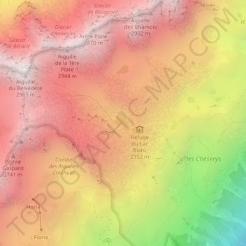
Name: Topografische Karte Lac Blanc, Höhe, Relief.
Durchschnittliche Höhe: 2.350 m
Minimale Höhe: 1.325 m
Maximale Höhe: 2.937 m
Spenden
Andere topografische Karten
Klicken Sie auf eine Karte, um ihre Topografie, ihre Höhe und ihr Relief anzuzeigen.
Mer de Glace
France > Auvergne-Rhône-Alpes > Upper Savoy > Chamonix-Mont-Blanc
The glacier lies above the Chamonix valley. The pressure within the ice is known to reach at least 30 atmospheres. The Mer de Glace can be considered as originating at an elevation of 2,100 metres (6,900 ft), just north of the Aiguille du Tacul, where it is formed by the confluence of the Glacier de Leschaux…
Durchschnittliche Höhe: 2.323 m
Argentière
France > Auvergne-Rhône-Alpes > Upper Savoy > Chamonix-Mont-Blanc
Argentière (French pronunciation: [aʁʒɑ̃tjɛʁ]) is a picturesque skiing, alpine walking and mountaineering village in the French Alps, part of the commune of Chamonix-Mont-Blanc, at an altitude of 1,252 m (4,108 ft).
Durchschnittliche Höhe: 1.674 m
Mer de Glace
France > Auvergne-Rhône-Alpes > Upper Savoy > Chamonix-Mont-Blanc
The glacier lies above the Chamonix valley. The pressure within the ice is known to reach at least 30 atmospheres. The Mer de Glace can be considered as originating at an elevation of 2,100 metres (6,900 ft), just north of the Aiguille du Tacul [fr], where it is formed by the confluence of the Glacier de…
Durchschnittliche Höhe: 2.322 m
Les Frasserands
France > Auvergne-Rhône-Alpes > Upper Savoy > Chamonix-Mont-Blanc > Argentière
Durchschnittliche Höhe: 1.704 m
Spenden
Les Granges
France > Auvergne-Rhône-Alpes > Upper Savoy > Chamonix-Mont-Blanc > Les Bossons
Durchschnittliche Höhe: 1.363 m
Aiguille du Midi
France > Auvergne-Rhône-Alpes > Upper Savoy > Chamonix-Mont-Blanc
The span of the second section is 2,867 m (1.781 mi) measured directly, but only 2,500 m (1.6 mi) measured horizontally. Thus it remains the second longest span width, measured directly. The cable car travels from Chamonix to the top of the Aiguille du Midi – an altitude gain of over 2,800 m (9,200 ft) –…
Durchschnittliche Höhe: 3.098 m
Le Tour
France > Auvergne-Rhône-Alpes > Upper Savoy > Chamonix-Mont-Blanc
Durchschnittliche Höhe: 1.811 m
Les Frasserands
France > Auvergne-Rhône-Alpes > Upper Savoy > Chamonix-Mont-Blanc > Argentière
Durchschnittliche Höhe: 1.704 m
Spenden
Le Tour
France > Auvergne-Rhône-Alpes > Upper Savoy > Chamonix-Mont-Blanc
Durchschnittliche Höhe: 1.811 m
Grande Rocheuse
France > Auvergne-Rhône-Alpes > Upper Savoy > Chamonix-Mont-Blanc
Durchschnittliche Höhe: 3.245 m
Montenvers
France > Auvergne-Rhône-Alpes > Upper Savoy > Chamonix-Mont-Blanc
Durchschnittliche Höhe: 1.801 m
Vers le Nant
France > Auvergne-Rhône-Alpes > Upper Savoy > Chamonix-Mont-Blanc > Les Bossons
Durchschnittliche Höhe: 1.357 m
Spenden
Les Plans
France > Auvergne-Rhône-Alpes > Upper Savoy > Chamonix-Mont-Blanc
Durchschnittliche Höhe: 1.416 m
Aiguille de Toula
France > Auvergne-Rhône-Alpes > Upper Savoy > Chamonix-Mont-Blanc
Durchschnittliche Höhe: 3.192 m
Aiguille du Plan
France > Auvergne-Rhône-Alpes > Upper Savoy > Chamonix-Mont-Blanc
Durchschnittliche Höhe: 2.955 m
Aiguille du Tacul
France > Auvergne-Rhône-Alpes > Upper Savoy > Chamonix-Mont-Blanc
Durchschnittliche Höhe: 2.782 m
Spenden
Montenvers
France > Auvergne-Rhône-Alpes > Upper Savoy > Chamonix-Mont-Blanc
Durchschnittliche Höhe: 1.801 m
Aiguille du Jardin
France > Auvergne-Rhône-Alpes > Upper Savoy > Chamonix-Mont-Blanc
Durchschnittliche Höhe: 3.254 m
Le Tour
France > Auvergne-Rhône-Alpes > Upper Savoy > Chamonix-Mont-Blanc
Durchschnittliche Höhe: 1.811 m
Le Tour
France > Auvergne-Rhône-Alpes > Upper Savoy > Chamonix-Mont-Blanc
Durchschnittliche Höhe: 1.811 m
Spenden
Les Bossons
France > Auvergne-Rhône-Alpes > Upper Savoy > Chamonix-Mont-Blanc
Durchschnittliche Höhe: 1.376 m