Geolokalisieren
👉 Easily get elevation data in JSON, GeoTIFF and KML formats using Elevation API
Vielen Dank für die Unterstützung dieser Website ❤️
Spenden

Topografische Karte Athirappilly

Klicken Sie auf die Karte, um die Höhe anzuzeigen.

👉 Easily get elevation data in JSON, GeoTIFF and KML formats using Elevation API
Vielen Dank für die Unterstützung dieser Website ❤️
Spenden

Über diese Karte

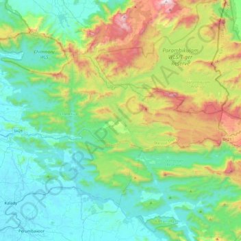
Name: Topografische Karte Athirappilly, Höhe, Relief.

Ort: Athirappilly, Chalakkudy, Thrissur District, Kerala, India (10.25126 76.44857 10.38597 76.90142)

Durchschnittliche Höhe: 406 m

Minimale Höhe: 0 m

Maximale Höhe: 1.604 m

👉 Easily get elevation data in JSON, GeoTIFF and KML formats using Elevation API
Vielen Dank für die Unterstützung dieser Website ❤️
Spenden

Andere topografische Karten

Klicken Sie auf eine Karte, um ihre Topografie, ihre Höhe und ihr Relief anzuzeigen.

Vallakkunnu

India > Kerala > Chalakkudy

Durchschnittliche Höhe: 10 m

Koratty

India > Kerala > Chalakkudy

Durchschnittliche Höhe: 14 m

Mala

India > Kerala > Chalakkudy

Durchschnittliche Höhe: 8 m

annamanada

India > Kerala > Chalakkudy

Durchschnittliche Höhe: 7 m

Vielen Dank für die Unterstützung dieser Website ❤️
Spenden

Valiyaparambu

India > Kerala > Chalakkudy

Durchschnittliche Höhe: 8 m

V.R Puram

India > Kerala > Chalakkudy

Durchschnittliche Höhe: 13 m

Nandipulam

India > Kerala > Chalakkudy

Durchschnittliche Höhe: 16 m

Pulikkanny

India > Kerala > Chalakkudy

Durchschnittliche Höhe: 36 m

Vielen Dank für die Unterstützung dieser Website ❤️
Spenden

Chalakudy

India > Kerala > Chalakkudy

Durchschnittliche Höhe: 15 m

Lower Sholayar Dam

India > Kerala > Chalakkudy

Durchschnittliche Höhe: 773 m

Chalakudy

India > Kerala > Chalakkudy

Durchschnittliche Höhe: 15 m

Chalakudy

India > Kerala > Chalakkudy

Durchschnittliche Höhe: 15 m

Vielen Dank für die Unterstützung dieser Website ❤️
Spenden