Geolokalisieren
👉 Easily get elevation data in JSON, GeoTIFF and KML formats using Elevation API
Vielen Dank für die Unterstützung dieser Website ❤️
Spenden

Topografische Karte Mala

Klicken Sie auf die Karte, um die Höhe anzuzeigen.

👉 Easily get elevation data in JSON, GeoTIFF and KML formats using Elevation API
Vielen Dank für die Unterstützung dieser Website ❤️
Spenden

Über diese Karte

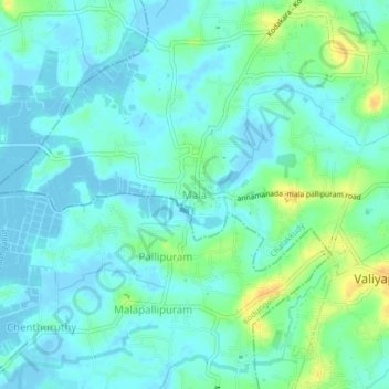
Name: Topografische Karte Mala, Höhe, Relief.

Ort: Mala, Chalakkudy, Thrissur District, Kerala, 680732, India (10.22030 76.24287 10.26030 76.28287)

Durchschnittliche Höhe: 8 m

Minimale Höhe: -5 m

Maximale Höhe: 27 m

👉 Easily get elevation data in JSON, GeoTIFF and KML formats using Elevation API
Vielen Dank für die Unterstützung dieser Website ❤️
Spenden

Andere topografische Karten

Klicken Sie auf eine Karte, um ihre Topografie, ihre Höhe und ihr Relief anzuzeigen.

Kuzhur

India > Kerala > Chalakkudy > Valiyaparambu

Durchschnittliche Höhe: 7 m

Kakkulissery

India > Kerala > Chalakkudy > Valiyaparambu

Durchschnittliche Höhe: 10 m

Thiruthiparambu East

India > Kerala > Chalakkudy > Chalakudy

Durchschnittliche Höhe: 10 m

Athirappilly

India > Kerala > Chalakkudy

Durchschnittliche Höhe: 406 m

Vielen Dank für die Unterstützung dieser Website ❤️
Spenden

Kadukutty

India > Kerala > Chalakkudy > Sampaloor

Durchschnittliche Höhe: 8 m

Nandipulam

India > Kerala > Chalakkudy

Durchschnittliche Höhe: 16 m

St James Hospital

India > Kerala > Chalakkudy > Chalakudy

Durchschnittliche Höhe: 14 m

Lower Sholayar Dam

India > Kerala > Chalakkudy

Durchschnittliche Höhe: 773 m

Vielen Dank für die Unterstützung dieser Website ❤️
Spenden

Mattathur

India > Kerala > Chalakkudy > Kodaly

Durchschnittliche Höhe: 199 m

St James Hospital

India > Kerala > Chalakkudy > Chalakudy

Durchschnittliche Höhe: 14 m