
Topografische Karte Kalayaan
Klicken Sie auf die Karte, um die Höhe anzuzeigen.
Kalayaan
Kalayaan is roughly rectangular in shape, with a hilly terrain on most of its eastern side, while relatively flat on its western side. Its highest elevations are from 400 to 418 metres. These are found in Sitio Santo Angel, Malaking Pulo, and Cabuhayan in Barangay San Juan, and Sitio Lamao in Barangay San Antonio. Approximately three fourths of the total land area are with terrain 300 metres above sea level. Its lowest points are from 5 to 20 metres along the western sections of Barangays San Juan and Longos towards Laguna de Bay.
Über diese Karte
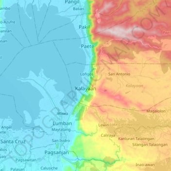
Name: Topografische Karte Kalayaan, Höhe, Relief.
Ort: Kalayaan, Laguna, Calabarzon, 4015, Philippines (14.30808 121.46175 14.35190 121.61449)
Durchschnittliche Höhe: 159 m
Minimale Höhe: -3 m
Maximale Höhe: 526 m
Andere topografische Karten
Klicken Sie auf eine Karte, um ihre Topografie, ihre Höhe und ihr Relief anzuzeigen.
UPLB CFNR Alumni Forest and Nature Park
Philippines > Laguna > Los Baños
Durchschnittliche Höhe: 148 m
Mount Makiling
Philippines > Laguna > Los Baños
Mount Makiling (also spelled Maquiling) is an inactive stratovolcano located in the provinces of Laguna and Batangas on the island of Luzon in the Philippines. The mountain rises to an elevation of 1,090 meters (3,580 ft) above mean sea level and is the highest feature of the Laguna Volcanic Field. The volcano…
Durchschnittliche Höhe: 753 m