
Topografische Karte Mount Makiling
Klicken Sie auf die Karte, um die Höhe anzuzeigen.
Über diese Karte
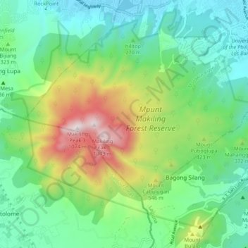
Name: Topografische Karte Mount Makiling, Höhe, Relief.
Ort: Mount Makiling, Los Baños, Laguna, Calabarzon, Philippines (14.10412 121.16334 14.16788 121.24431)
Durchschnittliche Höhe: 327 m
Minimale Höhe: 5 m
Maximale Höhe: 1.076 m
Andere topografische Karten
Klicken Sie auf eine Karte, um ihre Topografie, ihre Höhe und ihr Relief anzuzeigen.
Mount Makiling
Philippines > Laguna > Los Baños
Mount Makiling (also spelled Maquiling) is an inactive stratovolcano located in the provinces of Laguna and Batangas on the island of Luzon in the Philippines. The mountain rises to an elevation of 1,090 meters (3,580 ft) above mean sea level and is the highest feature of the Laguna Volcanic Field. The volcano…
Durchschnittliche Höhe: 753 m