
Topografische Karte Battle Ground
Interaktive Karte
Klicken Sie auf die Karte, um die Höhe anzuzeigen.
Über diese Karte
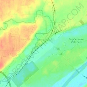
Name: Topografische Karte Battle Ground, Höhe, Relief.
Ort: Battle Ground, Tippecanoe County, Indiana, United States (40.49690 -86.87474 40.51664 -86.82860)
Durchschnittliche Höhe: 180 m
Minimale Höhe: 156 m
Maximale Höhe: 208 m
Battle Ground is located at 40°30′36″N 86°50′18″W / 40.51000°N 86.83833°W / 40.51000; -86.83833 (40.510110, −86.838220) in Tippecanoe Township, one and a quarter miles northwest of the Wabash River. Its elevation is approximately 585 feet. The small Harrison Creek begins near Battle Ground and flows east, while Burnett Creek skirts the town's western edge and flows southwest.
Andere topografische Karten
Klicken Sie auf eine Karte, um ihre Topografie, ihre Höhe und ihr Relief anzuzeigen.
West Lafayette
United States > Indiana > Tippecanoe County
West Lafayette, Tippecanoe County, Indiana, United States
Durchschnittliche Höhe: 192 m
Lafayette
United States > Indiana > Tippecanoe County
Lafayette, Tippecanoe County, Indiana, United States
Durchschnittliche Höhe: 193 m
Burnett's Creek
United States > Indiana > Tippecanoe County > Battle Ground
Burnett's Creek, Battle Ground, Tippecanoe County, Indiana, United States
Durchschnittliche Höhe: 179 m
Altamont Switch
United States > Indiana > Tippecanoe County > Lafayette
Altamont Switch, Lafayette, Tippecanoe County, Indiana, 47909, United States
Durchschnittliche Höhe: 197 m
Buck Creek
United States > Indiana > Tippecanoe County
Buck Creek, Tippecanoe County, Indiana, 47924, United States
Durchschnittliche Höhe: 202 m
West Point
United States > Indiana > Tippecanoe County
West Point, Tippecanoe County, Indiana, 47992, United States
Durchschnittliche Höhe: 198 m