
Topografische Karte West Lafayette
Interaktive Karte
Klicken Sie auf die Karte, um die Höhe anzuzeigen.
Über diese Karte
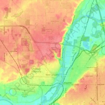
Name: Topografische Karte West Lafayette, Höhe, Relief.
Ort: West Lafayette, Tippecanoe County, Indiana, United States (40.40002 -86.96244 40.48954 -86.88698)
Durchschnittliche Höhe: 192 m
Minimale Höhe: 150 m
Maximale Höhe: 225 m
West Lafayette lies in central Tippecanoe County and overlooks the Wabash River, which borders the city on the east and south. Most of the city lies in eastern Wabash Township, though a small portion on the northeast side extends into Tippecanoe Township. Elevations range from slightly over 500 feet (150 m) near the river to more than 720 feet (220 m) in northern parts of the city near U.S. Route 52.
Andere topografische Karten
Klicken Sie auf eine Karte, um ihre Topografie, ihre Höhe und ihr Relief anzuzeigen.
Lafayette
United States > Indiana > Tippecanoe County
Lafayette, Tippecanoe County, Indiana, United States
Durchschnittliche Höhe: 193 m
Burnett's Creek
United States > Indiana > Tippecanoe County > Battle Ground
Burnett's Creek, Battle Ground, Tippecanoe County, Indiana, United States
Durchschnittliche Höhe: 179 m
Battle Ground
United States > Indiana > Tippecanoe County
Battle Ground, Tippecanoe County, Indiana, United States
Durchschnittliche Höhe: 180 m
Altamont Switch
United States > Indiana > Tippecanoe County > Lafayette
Altamont Switch, Lafayette, Tippecanoe County, Indiana, 47909, United States
Durchschnittliche Höhe: 197 m
Buck Creek
United States > Indiana > Tippecanoe County
Buck Creek, Tippecanoe County, Indiana, 47924, United States
Durchschnittliche Höhe: 202 m
West Point
United States > Indiana > Tippecanoe County
West Point, Tippecanoe County, Indiana, 47992, United States
Durchschnittliche Höhe: 198 m