
Topografische Karte West Point
Interaktive Karte
Klicken Sie auf die Karte, um die Höhe anzuzeigen.
Über diese Karte
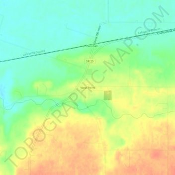
Name: Topografische Karte West Point, Höhe, Relief.
Ort: West Point, Tippecanoe County, Indiana, 47992, United States (40.32468 -87.06218 40.36468 -87.02218)
Durchschnittliche Höhe: 198 m
Minimale Höhe: 176 m
Maximale Höhe: 222 m
Andere topografische Karten
Klicken Sie auf eine Karte, um ihre Topografie, ihre Höhe und ihr Relief anzuzeigen.
West Lafayette
United States > Indiana > Tippecanoe County
West Lafayette, Tippecanoe County, Indiana, United States
Durchschnittliche Höhe: 192 m
Lafayette
United States > Indiana > Tippecanoe County
Lafayette, Tippecanoe County, Indiana, United States
Durchschnittliche Höhe: 193 m
Burnett's Creek
United States > Indiana > Tippecanoe County > Battle Ground
Burnett's Creek, Battle Ground, Tippecanoe County, Indiana, United States
Durchschnittliche Höhe: 179 m
Battle Ground
United States > Indiana > Tippecanoe County
Battle Ground, Tippecanoe County, Indiana, United States
Durchschnittliche Höhe: 180 m
Altamont Switch
United States > Indiana > Tippecanoe County > Lafayette
Altamont Switch, Lafayette, Tippecanoe County, Indiana, 47909, United States
Durchschnittliche Höhe: 197 m
Buck Creek
United States > Indiana > Tippecanoe County
Buck Creek, Tippecanoe County, Indiana, 47924, United States
Durchschnittliche Höhe: 202 m