Geolokalisieren
👉 Easily get elevation data in JSON, GeoTIFF and KML formats using Elevation API
Vielen Dank für die Unterstützung dieser Website ❤️
Spenden

Topografische Karte North Yorkshire

Klicken Sie auf die Karte, um die Höhe anzuzeigen.

👉 Easily get elevation data in JSON, GeoTIFF and KML formats using Elevation API
Vielen Dank für die Unterstützung dieser Website ❤️
Spenden

Über diese Karte

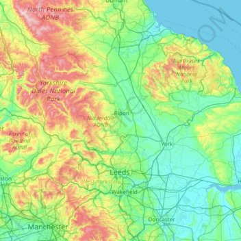
Name: Topografische Karte North Yorkshire, Höhe, Relief.

Ort: North Yorkshire, England, United Kingdom (53.62109 -2.56474 54.56214 -0.21235)

Durchschnittliche Höhe: 153 m

Minimale Höhe: -1 m

Maximale Höhe: 880 m

👉 Easily get elevation data in JSON, GeoTIFF and KML formats using Elevation API
Vielen Dank für die Unterstützung dieser Website ❤️
Spenden

Andere topografische Karten

Klicken Sie auf eine Karte, um ihre Topografie, ihre Höhe und ihr Relief anzuzeigen.

London

United Kingdom > England > London

Durchschnittliche Höhe: 42 m

Scarborough

United Kingdom > England > North Yorkshire

The climate is temperate with mild summers and cool, windy, winters. The hottest months of the year are July and August, with temperatures reaching an average high of 17 °C and falling to 11 °C at night. The average daytime temperatures in January are 4 °C, falling to 1 °C at night. The station's elevation…

Durchschnittliche Höhe: 39 m

Croydon

United Kingdom > England > Greater London

Several apartment developments, for instance Altitude 25 (completed 2010), have been built in recent years, and several more are being built or planned. The construction of Saffron Square, which includes a 43-storey tower, began on Wellesley Road in 2011 and was completed in 2016. Other developments with…

Durchschnittliche Höhe: 70 m

Putney

United Kingdom > England

Putney Heath is around 400 acres (160 hectares) less the nascent A3 road in size and rises to 45 metres (148 ft) above sea level. Because of its elevation, from 1796 to 1816 Putney Heath hosted a station in the shutter telegraph chain, which connected the Admiralty in London to its naval ships in Portsmouth.…

Durchschnittliche Höhe: 18 m

Vielen Dank für die Unterstützung dieser Website ❤️
Spenden

Crewe

United Kingdom > England > Crewe

Durchschnittliche Höhe: 53 m

Derby

United Kingdom > England > Derbyshire

Durchschnittliche Höhe: 97 m

Newport

United Kingdom > England > Telford and Wrekin

Durchschnittliche Höhe: 81 m

City of London

United Kingdom > England > City of London > City of London

The elevation of the City ranges from sea level at the Thames to 21.6 metres (71 ft) at the junction of High Holborn and Chancery Lane. Two small but notable hills are within the historic core, Ludgate Hill to the west and Cornhill to the east. Between them ran the Walbrook, one of the many "lost" rivers or…

Durchschnittliche Höhe: 42 m

Vielen Dank für die Unterstützung dieser Website ❤️
Spenden

St Austell

United Kingdom > England > St Austell

Durchschnittliche Höhe: 104 m

Chester

United Kingdom > England > Cheshire West and Chester

Durchschnittliche Höhe: 61 m

Plymouth

United Kingdom > England > Devon > Plymouth

The River Plym, which flows off Dartmoor to the north-east, forms a smaller estuary to the east of the city called Cattewater. Plymouth Sound is protected from the sea by the Plymouth Breakwater, in use since 1814. In the Sound is Drake's Island which is seen from Plymouth Hoe, a flat public area on top of…

Durchschnittliche Höhe: 81 m

Oakworth

United Kingdom > England > Bradford

Durchschnittliche Höhe: 226 m

Vielen Dank für die Unterstützung dieser Website ❤️
Spenden

Richmond Park

United Kingdom > England > Greater London

Durchschnittliche Höhe: 26 m

Hyde Park

United Kingdom > England > London

"It consists of a screen of handsome fluted Ionic columns, with three carriage entrance archways, two-foot entrances, a lodge, etc. The extent of the whole frontage is about 107 ft (33 m). The central entrance has a bold projection: the entablature is supported by four columns; and the volutes of the capitals…

Durchschnittliche Höhe: 25 m

Woolacombe

United Kingdom > England > Devon > North Devon

Durchschnittliche Höhe: 81 m

Gainsborough

United Kingdom > England > Gainsborough

Durchschnittliche Höhe: 15 m

Vielen Dank für die Unterstützung dieser Website ❤️
Spenden

Cranbrook

United Kingdom > England > Kent > Tunbridge Wells

Durchschnittliche Höhe: 76 m

Sidmouth

United Kingdom > England > Sidmouth

Durchschnittliche Höhe: 54 m

York

United Kingdom > England > York

Durchschnittliche Höhe: 21 m

Leeds

United Kingdom > England

Lying in the eastern foothills of the Pennines, there is a significant variation in elevation within the city's built-up area. The district ranges from 1,115 feet (340 m) in the far west on the slopes of Ilkley Moor to about 33 feet (10 m) where the rivers Aire and Wharfe cross the eastern boundary. Land rises…

Durchschnittliche Höhe: 94 m

Vielen Dank für die Unterstützung dieser Website ❤️
Spenden

Littleborough

United Kingdom > England

In the late 18th century, the low-altitude Summit Gap between Littleborough and Walsden was approved as the best route over the Pennines for the Rochdale Canal and the Manchester to Leeds railway; Hollingworth Lake was built at Littleborough's south side as a feeder reservoir to regulate the waters of the…

Durchschnittliche Höhe: 266 m

Temple

United Kingdom > England > Cornwall

Durchschnittliche Höhe: 246 m

Ealing

United Kingdom > England > Greater London

Durchschnittliche Höhe: 26 m

Leigh

United Kingdom > England

Durchschnittliche Höhe: 34 m

Vielen Dank für die Unterstützung dieser Website ❤️
Spenden

Salisbury

United Kingdom > England > Salisbury

Bishop of Salisbury Hubert Walter was instrumental in the negotiations with Saladin during the Third Crusade, but he spent little time in his diocese prior to his elevation to archbishop of Canterbury. The brothers Herbert and Richard Poore succeeded him and began planning the relocation of the cathedral into…

Durchschnittliche Höhe: 96 m

Cambridge

United Kingdom > England > Cambridge

The city, like most of the UK, has a maritime climate highly influenced by the Gulf Stream. Located in the driest region of Britain, Cambridge's rainfall averages around 570 mm (22.44 in) per year, around half the national average, with some years occasionally falling into the semi-arid (under 500 mm (19.69…

Durchschnittliche Höhe: 18 m

Eccles Pike

United Kingdom > England > Derbyshire > High Peak > Chapel-en-le-Frith > Whitehough > Whitehough Head

At the top of the hill is a commemorative plaque known as a topograph, showing a 360° relief of the surrounding landscape, placed by the community to mark the millennium. In early November 2011, the topograph was stolen. On 7 May 2013, it was replaced with one made from less valuable metal to discourage…

Durchschnittliche Höhe: 233 m

Southowram

United Kingdom > England > Calderdale

Durchschnittliche Höhe: 142 m

Vielen Dank für die Unterstützung dieser Website ❤️
Spenden

Hengistbury Head

United Kingdom > England > Bournemouth, Christchurch and Poole > Bournemouth

In 1910 the first international aviation meeting ever held in Britain took place on a specially laid out aerodrome consisting of a mile of grassland between the "Double Dykes" and the nearby village of Tuckton. About twenty pioneer aviators from around the world participated in various competitions including…

Durchschnittliche Höhe: 0 m

Banbury

United Kingdom > England > Cherwell > Banbury

Durchschnittliche Höhe: 119 m

Portsmouth

United Kingdom > England > Hampshire > Portsmouth

By road, Portsmouth lies 73.5 miles (118.3 km) from Central London, 49.5 miles (79.7 km) west of Brighton, and 22.3 miles (35.9 km) east of Southampton. Portsmouth is situated primarily on Portsea Island and is the United Kingdom's only island city, although parts of it have expanded onto the mainland. Gosport…

Durchschnittliche Höhe: 28 m

Carlisle

United Kingdom > England > Cumberland

Durchschnittliche Höhe: 31 m

Vielen Dank für die Unterstützung dieser Website ❤️
Spenden

Richmond

United Kingdom > England > London

The town centre lies just below 33 ft (10m) above sea level. South of the town centre, rising from Richmond Bridge to an elevation of 165 ft (50m), is Richmond Hill. Just beyond the summit of Richmond Hill is Richmond Park, an area of 2,360 acres (9.55 km2; 3.7 sq mi) of wild heath and woodland originally…

Durchschnittliche Höhe: 17 m

Durham

United Kingdom > England > County Durham

Durchschnittliche Höhe: 119 m

Stroud

United Kingdom > England > Gloucestershire > Stroud

Durchschnittliche Höhe: 135 m

High Willhays

United Kingdom > England > Devon > West Devon

High Willhays and Yes Tor are the only summits in England south of Kinder Scout in the Peak District to rise above 2,000 feet (610 m), apart from Black Mountain on the Welsh border. Before Ordnance Survey measured accurately the heights of High Willhays and Yes Tor many people believed Yes Tor was the higher…

Durchschnittliche Höhe: 512 m

Vielen Dank für die Unterstützung dieser Website ❤️
Spenden

Grindsbrook Booth

United Kingdom > England > Derbyshire > High Peak > Edale

Durchschnittliche Höhe: 387 m

Castle Bytham

United Kingdom > England > Lincolnshire > South Kesteven

Durchschnittliche Höhe: 77 m

Arborfield

United Kingdom > England > Borough of Wokingham

Durchschnittliche Höhe: 57 m

Rawmarsh

United Kingdom > England

Durchschnittliche Höhe: 64 m

Vielen Dank für die Unterstützung dieser Website ❤️
Spenden

Polzeath

United Kingdom > England > Cornwall

Durchschnittliche Höhe: 25 m

Apperley Bridge

United Kingdom > England > Bradford

Durchschnittliche Höhe: 118 m

Stanley Park

United Kingdom > England > Liverpool

Durchschnittliche Höhe: 43 m

Vielen Dank für die Unterstützung dieser Website ❤️
Spenden

Oxford

United Kingdom > England > Oxfordshire > Oxford

Durchschnittliche Höhe: 81 m

Exeter

United Kingdom > England > Devon > Exeter

The city of Exeter was established on the eastern bank of the River Exe on a ridge of land backed by a steep hill. It is at this point that the Exe, having just been joined by the River Creedy, opens onto a wide flood plain and estuary which results in quite common flooding. Historically this was the lowest…

Durchschnittliche Höhe: 99 m

Cheshunt

United Kingdom > England > Hertfordshire

Durchschnittliche Höhe: 43 m

Vielen Dank für die Unterstützung dieser Website ❤️
Spenden

Stoke

United Kingdom > England > Stoke-on-Trent

Durchschnittliche Höhe: 142 m

Darlington

United Kingdom > England > Darlington

Durchschnittliche Höhe: 52 m

Epsom Downs

United Kingdom > England > Epsom and Ewell

Durchschnittliche Höhe: 118 m

Emley Moor

United Kingdom > England > Kirklees

Durchschnittliche Höhe: 210 m

Vielen Dank für die Unterstützung dieser Website ❤️
Spenden

Dunkery Beacon

United Kingdom > England > Somerset

Durchschnittliche Höhe: 393 m

Ashdown Forest

United Kingdom > England > East Sussex > Wealden

Ashdown Forest is an ancient area of open heathland occupying the highest sandy ridge-top of the High Weald Area of Outstanding Natural Beauty. It is situated 30 miles (48 km) south of London in the county East Sussex, England. Rising to an elevation of 732 feet (223 m) above sea level, its heights provide…

Durchschnittliche Höhe: 117 m

Kentmere

United Kingdom > England > Westmorland and Furness > Kentmere

Durchschnittliche Höhe: 334 m

Royton

United Kingdom > England

Described in Samuel Lewis's A Topographical Dictionary of England (1848) as being in "aspect rather wild", Royton lies in a shallow valley amongst undulating land. The sources of the rivers Irk and Beal are to the northeast and east respectively. The Irk meanders southwesterly into Chadderton, and then onwards…

Durchschnittliche Höhe: 181 m

Vielen Dank für die Unterstützung dieser Website ❤️
Spenden

Edgbaston Reservoir

United Kingdom > England > Birmingham

Durchschnittliche Höhe: 155 m

Durdle Door

United Kingdom > England > West Lulworth

Durchschnittliche Höhe: 48 m

Dronfield

United Kingdom > England > Dronfield

Durchschnittliche Höhe: 159 m

Vielen Dank für die Unterstützung dieser Website ❤️
Spenden

Prestwich

United Kingdom > England

Durchschnittliche Höhe: 76 m

Worksop

United Kingdom > England > Nottinghamshire > Bassetlaw

Durchschnittliche Höhe: 56 m

Biggin Hill

United Kingdom > England > London

Durchschnittliche Höhe: 171 m

Macclesfield

United Kingdom > England > Macclesfield

Durchschnittliche Höhe: 189 m

Vielen Dank für die Unterstützung dieser Website ❤️
Spenden

Retford

United Kingdom > England > Nottinghamshire > Bassetlaw

In 1831, the Gas Works was built by James Malam and gaslights were lit in the town for the first time on 22 December 1831. The Square was lit by a cast iron light bearing five gas lamps at that time. The Gas Works became a target on 2 September 1916 when a German Zeppelin dropped 14 bombs on Retford. The…

Durchschnittliche Höhe: 31 m

Fairford

United Kingdom > England > Gloucestershire > Cotswold District

Durchschnittliche Höhe: 96 m

Haywards Heath

United Kingdom > England > Haywards Heath

Durchschnittliche Höhe: 65 m

Matlock

United Kingdom > England > Derbyshire > Derbyshire Dales

Durchschnittliche Höhe: 213 m

Vielen Dank für die Unterstützung dieser Website ❤️
Spenden

Ormskirk

United Kingdom > England > Lancashire > West Lancashire

Durchschnittliche Höhe: 39 m

Blackburn

United Kingdom > England > Blackburn with Darwen

Durchschnittliche Höhe: 157 m

Sherborne

United Kingdom > England > Sherborne

Durchschnittliche Höhe: 91 m

Basingstoke

United Kingdom > England > Hampshire > Basingstoke and Deane

Situated in a valley through the Hampshire Downs at an average elevation of 88 metres (289 ft) Basingstoke is a major interchange between Reading, Newbury, Andover, Winchester, and Alton, and lies on the natural trade route between the southwest of England and London. The area had been something of an…

Durchschnittliche Höhe: 109 m

Vielen Dank für die Unterstützung dieser Website ❤️
Spenden

Frome

United Kingdom > England > Somerset

Durchschnittliche Höhe: 97 m

Redhill

United Kingdom > England > Surrey > Reigate and Banstead

To the north, the town joins with the village of Merstham, north of which there is a "wind gap" in the chalk hills of the North Downs, at an elevation of 120 metres (390 ft) above sea level, through which the A23 road heads in from London. Geologists have speculated that there may once have been a…

Durchschnittliche Höhe: 107 m

St Albans

United Kingdom > England > Hertfordshire > St Albans

St Albans was an ancient borough created following the dissolution of the monastery in 1539. It consisted of the ancient parish of St Albans (also known as the Abbey parish) and parts of St Michael and St Peter. The municipal corporation was reformed by the Municipal Corporations Act 1835 and the boundary was…

Durchschnittliche Höhe: 100 m

Swindon

United Kingdom > England > Swindon

Swindon has an oceanic climate (Cfb in the Köppen climate classification), like the vast majority of the British Isles, with cool winters and warm summers. The nearest official weather station is RAF Lyneham, about 10 miles (16 km) west southwest of Swindon town centre. The weather station's elevation is 145…

Durchschnittliche Höhe: 108 m

Vielen Dank für die Unterstützung dieser Website ❤️
Spenden

Heswall

United Kingdom > England

Durchschnittliche Höhe: 36 m

Moreton

United Kingdom > England

Durchschnittliche Höhe: 16 m

Poole Bay

United Kingdom > England

Durchschnittliche Höhe: 0 m

Bideford Bay

United Kingdom > England

Durchschnittliche Höhe: 0 m

Vielen Dank für die Unterstützung dieser Website ❤️
Spenden

Mount's Bay

United Kingdom > England

Durchschnittliche Höhe: 0 m

Falmouth Bay

United Kingdom > England

Durchschnittliche Höhe: 0 m

Lyme Bay

United Kingdom > England

Durchschnittliche Höhe: 0 m

Liverpool Bay

United Kingdom > England

Durchschnittliche Höhe: 0 m

Vielen Dank für die Unterstützung dieser Website ❤️
Spenden

Gayton

United Kingdom > England

Durchschnittliche Höhe: 41 m

Keston

United Kingdom > England

Durchschnittliche Höhe: 104 m

Harefield

United Kingdom > England

Durchschnittliche Höhe: 66 m

Eastham Village

United Kingdom > England

Durchschnittliche Höhe: 24 m

Vielen Dank für die Unterstützung dieser Website ❤️
Spenden

Leigh

United Kingdom > England

Durchschnittliche Höhe: 34 m

Greasby

United Kingdom > England

Durchschnittliche Höhe: 32 m

Middleton

United Kingdom > England

Durchschnittliche Höhe: 113 m

Atherton

United Kingdom > England

There were several ministers of note of Chowbent Chapel including James Wood, the "General" (1672–1759), who distinguished himself at the Battle of Preston in 1715. Thomas Walker Horsfield (1792–1837) was a historian and topographer. Joseph Nightingale (1775–1824), born in Chowbent, was a prolific…

Durchschnittliche Höhe: 69 m

Vielen Dank für die Unterstützung dieser Website ❤️
Spenden

Tottenham

United Kingdom > England

Tottenham's elevation is approximately 33 ft (10 m) above sea level.

Durchschnittliche Höhe: 25 m

Old Town

United Kingdom > England

Durchschnittliche Höhe: 7 m

Raby Mere

United Kingdom > England

Durchschnittliche Höhe: 33 m

Acton

United Kingdom > England

Durchschnittliche Höhe: 23 m

Vielen Dank für die Unterstützung dieser Website ❤️
Spenden

Carding Mill

United Kingdom > England > Shropshire > Church Stretton

Durchschnittliche Höhe: 328 m

Noak Hill

United Kingdom > England

Durchschnittliche Höhe: 67 m

Shining Tor

United Kingdom > England > Cheshire East

Shining Tor is the highest hill in Cheshire, England. The summit has an elevation of 559 m (1,834 ft) above sea level. It is in the Peak District, between the towns of Macclesfield in Cheshire and Buxton in Derbyshire, and is on the administrative boundary between Derbyshire and Cheshire East. The hill is at…

Durchschnittliche Höhe: 440 m

Wath upon Dearne

United Kingdom > England

Durchschnittliche Höhe: 51 m

Vielen Dank für die Unterstützung dieser Website ❤️
Spenden