Geolokalisieren
👉 Easily get elevation data in JSON, GeoTIFF and KML formats using Elevation API
Vielen Dank für die Unterstützung dieser Website ❤️
Spenden

Topografische Karte Lewisham

Klicken Sie auf die Karte, um die Höhe anzuzeigen.

👉 Easily get elevation data in JSON, GeoTIFF and KML formats using Elevation API
Vielen Dank für die Unterstützung dieser Website ❤️
Spenden

Über diese Karte

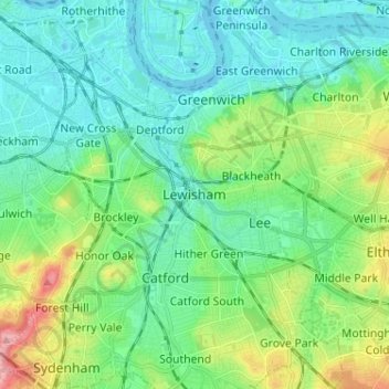
Name: Topografische Karte Lewisham, Höhe, Relief.

Ort: Lewisham, Greater London, England, SE13 6BB, United Kingdom (51.42243 -0.05018 51.50243 0.02982)

Durchschnittliche Höhe: 28 m

Minimale Höhe: -2 m

Maximale Höhe: 113 m

👉 Easily get elevation data in JSON, GeoTIFF and KML formats using Elevation API
Vielen Dank für die Unterstützung dieser Website ❤️
Spenden

Andere topografische Karten

Klicken Sie auf eine Karte, um ihre Topografie, ihre Höhe und ihr Relief anzuzeigen.

Greater London

United Kingdom > England

Durchschnittliche Höhe: 66 m

Liverpool

United Kingdom > England

Durchschnittliche Höhe: 26 m

Bristol

United Kingdom > England > City of Bristol

Durchschnittliche Höhe: 55 m

Sheffield

United Kingdom > England

Sheffield nestles on the eastern foothills of the Pennines and is sculpted by a dramatic hill-and-valley system formed where five rivers — the Don, Sheaf, Rivelin, Loxley and Porter — converge, producing steep-sided valleys and gritstone ridgelines with much of the urban area built directly onto hillsides…

Durchschnittliche Höhe: 168 m

Vielen Dank für die Unterstützung dieser Website ❤️
Spenden

Cambridge

United Kingdom > England > Cambridge

The city, like most of the UK, has a maritime climate highly influenced by the Gulf Stream. Located in the driest region of Britain, Cambridge's rainfall averages around 570 mm (22.44 in) per year, around half the national average, with some years occasionally falling into the semi-arid (under 500 mm (19.69…

Durchschnittliche Höhe: 18 m

Nottingham

United Kingdom > England > Nottinghamshire

Durchschnittliche Höhe: 56 m

Bath

United Kingdom > England > Bath and North East Somerset

Bath is in the Avon Valley and is surrounded by limestone hills as it is near the southern edge of the Cotswolds, a designated Area of Outstanding Natural Beauty, and the limestone Mendip Hills rise around 7 miles (11 km) south of the city. The hills that surround and make up the city have a maximum altitude…

Durchschnittliche Höhe: 100 m

Kent

United Kingdom > England

Kent was also the location of the largest number of art schools in the country during the nineteenth century, estimated by the art historian David Haste, to approach two hundred. This is believed to be the result of Kent being a front line county during the Napoleonic Wars. At this time, before the invention…

Durchschnittliche Höhe: 37 m

Vielen Dank für die Unterstützung dieser Website ❤️
Spenden

Brighton

United Kingdom > England > Brighton and Hove

Durchschnittliche Höhe: 64 m

Norfolk

United Kingdom > England

Durchschnittliche Höhe: 23 m

Lake District National Park

United Kingdom > England

The Lake District is a roughly circular upland massif, deeply dissected by a broadly radial pattern of major valleys which are largely the result of repeated glaciations over the last 2 million years. The apparent radial pattern is not from a central dome, but from an axial watershed extending from St Bees…

Durchschnittliche Höhe: 206 m

South East England

United Kingdom > England

Near Weybridge are the UK headquarters of Sony with SSP Group (situated in Byfleet) and Procter & Gamble (next door to each other on The Heights Business Park near the former Brooklands racing circuit) with Kia Motors UK and Petroleum Geo-Services UK, and Gallaher Group (cigarettes) is to the north, next to…

Durchschnittliche Höhe: 69 m

Vielen Dank für die Unterstützung dieser Website ❤️
Spenden

Surrey

United Kingdom > England > Surrey

The highest elevation in Surrey is Leith Hill near Dorking. It is 295 m (968 ft) above sea level and is the second highest point in southeastern England after Walbury Hill in West Berkshire which is 297 m (974 ft).

Durchschnittliche Höhe: 69 m

Oxford

United Kingdom > England > Oxfordshire

Durchschnittliche Höhe: 81 m

Leeds

United Kingdom > England

Durchschnittliche Höhe: 96 m

Birmingham

United Kingdom > England

Birmingham is a snowy city relative to other large UK conurbations, due to its inland location and comparatively high elevation. Between 1961 and 1990 Birmingham Airport averaged 13.0 days of snow lying annually, compared to 5.33 at London Heathrow. Snow showers often pass through the city via the Cheshire gap…

Durchschnittliche Höhe: 138 m

Vielen Dank für die Unterstützung dieser Website ❤️
Spenden

Cornwall

United Kingdom > England

The interior of the county consists of a roughly east–west spine of infertile and exposed upland, with a series of granite intrusions, such as Bodmin Moor, which contains the highest land within Cornwall. From east to west, and with approximately descending altitude, these are Bodmin Moor, Hensbarrow north…

Durchschnittliche Höhe: 55 m

Northamptonshire

United Kingdom > England

Durchschnittliche Höhe: 97 m

Suffolk

United Kingdom > England

The west of the county lies on more resistant Cretaceous chalk. This chalk is responsible for a sweeping tract of largely downland landscapes that stretches from Dorset in the south west to Dover in the south east and north through East Anglia to the Yorkshire Wolds. The chalk is less easily eroded so forms…

Durchschnittliche Höhe: 35 m

Southampton

United Kingdom > England

Durchschnittliche Höhe: 22 m

Vielen Dank für die Unterstützung dieser Website ❤️
Spenden

Shropshire

United Kingdom > England

Durchschnittliche Höhe: 166 m

Wiltshire

United Kingdom > England

Durchschnittliche Höhe: 115 m

East Midlands

United Kingdom > England

The highest point at 636 m (2,087 ft) is Kinder Scout, in the Peak District of the southern Pennines in northwest Derbyshire near Glossop. Other hilly areas of 95 to 280 m (312 to 919 ft) in altitude, together with lakes and reservoirs, rise in and around the Charnwood Forest north of Peterborough, Leicester,…

Durchschnittliche Höhe: 75 m

Yorkshire

United Kingdom > England

In Yorkshire there is a very close relationship between the major topographical areas and the geological period in which they were formed. The Pennine chain of hills in the west is of Carboniferous origin. The central vale is Permo-Triassic. The North York Moors in the north-east of the county are Jurassic in…

Durchschnittliche Höhe: 130 m

Vielen Dank für die Unterstützung dieser Website ❤️
Spenden

Greater London

United Kingdom > England

London's topography is characterized by a gently rolling terrain shaped by the River Thames and its tributaries. The city lies within the London Basin, a natural depression bordered by higher grounds such as the North Downs to the south and the Chiltern Hills to the northwest. The Thames flows west to east,…

Durchschnittliche Höhe: 66 m

City of Bristol

United Kingdom > England

Durchschnittliche Höhe: 80 m

Hertfordshire

United Kingdom > England

Elevations are higher in the north and west, reaching more than 800 feet (240 m) in the Chilterns near Tring. The county centres on the headwaters and upper valleys of the rivers Lea and the Colne; both flow south, and each is accompanied by a canal. Hertfordshire's undeveloped land is mainly agricultural,…

Durchschnittliche Höhe: 82 m

Peak District National Park

United Kingdom > England > Derbyshire

Durchschnittliche Höhe: 225 m

Vielen Dank für die Unterstützung dieser Website ❤️
Spenden

Manchester

United Kingdom > England

Durchschnittliche Höhe: 66 m

Wigan

United Kingdom > England

Durchschnittliche Höhe: 74 m

Eaton

United Kingdom > England > Cheshire East > Eaton

Durchschnittliche Höhe: 115 m

Brixham

United Kingdom > England > Torbay

Durchschnittliche Höhe: 38 m

Vielen Dank für die Unterstützung dieser Website ❤️
Spenden

Beckton District Park

United Kingdom > England > London

Durchschnittliche Höhe: 4 m

Mevagissey

United Kingdom > England > Cornwall

Durchschnittliche Höhe: 44 m

Castleton

United Kingdom > England > Derbyshire > High Peak > Castleton

Durchschnittliche Höhe: 326 m

North East England

United Kingdom > England

North East England has a Marine west coast climate (generally found along the west coast of middle latitude continents) with narrower temperature ranges than the south of England and sufficient precipitation in all months. Summers and winters are mild rather than extremely hot or cold, due to the strong…

Durchschnittliche Höhe: 165 m

Vielen Dank für die Unterstützung dieser Website ❤️
Spenden

Weymouth

United Kingdom > England > Dorset

Durchschnittliche Höhe: 36 m

Cheshire

United Kingdom > England

Durchschnittliche Höhe: 103 m

East Sussex

United Kingdom > England

Durchschnittliche Höhe: 43 m

Derbyshire

United Kingdom > England

Due to its central location in England and altitude range from 27 metres in the south to 636 metres in the north, Derbyshire contains many species at the edge of their UK distribution ranges. Some species with a predominantly northern British distribution are at the southern limit of their range, whilst others…

Durchschnittliche Höhe: 144 m

Vielen Dank für die Unterstützung dieser Website ❤️
Spenden

Wirral

United Kingdom > England

Durchschnittliche Höhe: 21 m

Devon

United Kingdom > England

Durchschnittliche Höhe: 94 m

Rugby

United Kingdom > England > Warwickshire

Durchschnittliche Höhe: 112 m

Lincoln

United Kingdom > England > Lincolnshire

Lincoln lies 157 mi (253 km) north of London, at an altitude of 67 ft (20.4 m) by the River Witham up to 246 ft (75.0 m) on Castle Hill. It fills a gap in the Lincoln Cliff escarpment, which runs north and south through central Lincolnshire, with altitudes up to 200 feet (61 metres). The city lies on the River…

Durchschnittliche Höhe: 29 m

Vielen Dank für die Unterstützung dieser Website ❤️
Spenden

Bradford

United Kingdom > England

Durchschnittliche Höhe: 175 m

Coventry

United Kingdom > England

Durchschnittliche Höhe: 99 m

Newcastle upon Tyne

United Kingdom > England > Tyne and Wear

Durchschnittliche Höhe: 57 m

Boston Spa

United Kingdom > England

Durchschnittliche Höhe: 34 m

Vielen Dank für die Unterstützung dieser Website ❤️
Spenden

Cottingham

United Kingdom > England > East Riding of Yorkshire

Durchschnittliche Höhe: 13 m

Bicester

United Kingdom > England > Oxfordshire > Cherwell District

Bicester has expanded rapidly in recent generations due to the town's picturesque historical town centre, garden town layout, independent and high-street shops, restaurants, as well as a rail connection to Oxford. It also boasts imminent connection to Cambridge, as well as rail links to Birmingham and London.…

Durchschnittliche Höhe: 77 m

East of England

United Kingdom > England

The East of England region has the lowest elevation range in the UK. Twenty percent of the region is below mean sea level, most of this in North Cambridgeshire, Norfolk and on the Essex Coast. Most of the remaining area is of low elevation, with extensive glacial deposits. The Fens, a large area of reclaimed…

Durchschnittliche Höhe: 39 m

City of Durham

United Kingdom > England > County Durham > Durham

Durchschnittliche Höhe: 76 m

Vielen Dank für die Unterstützung dieser Website ❤️
Spenden

Staffordshire

United Kingdom > England

Durchschnittliche Höhe: 130 m

Worcestershire

United Kingdom > England

Durchschnittliche Höhe: 99 m

Isle of Wight

United Kingdom > England

Durchschnittliche Höhe: 17 m

Leicestershire

United Kingdom > England

A large part of the north-west of the county, around Coalville, forms part of the new National Forest area extending into Derbyshire and Staffordshire. The highest point of the county is Bardon Hill at 278 m (912 ft), which is also a Marilyn; with other hilly/upland areas of around 150–200 metres (490–660…

Durchschnittliche Höhe: 97 m

Vielen Dank für die Unterstützung dieser Website ❤️
Spenden

Greater London

United Kingdom > England

Durchschnittliche Höhe: 66 m

Cambridgeshire

United Kingdom > England

Cambridgeshire has a maritime temperate climate which is broadly similar to the rest of the United Kingdom, though it is drier than the UK average due to its low altitude and easterly location, the prevailing southwesterly winds having already deposited moisture on higher ground further west. Average winter…

Durchschnittliche Höhe: 32 m

North Yorkshire

United Kingdom > England

Durchschnittliche Höhe: 153 m

Stockport

United Kingdom > England

Durchschnittliche Höhe: 95 m

Vielen Dank für die Unterstützung dieser Website ❤️
Spenden

Ipswich

United Kingdom > England > Suffolk

Ipswich experiences an oceanic climate, like the rest of the British Isles, with a narrow range of temperature and rainfall spread evenly throughout the year. One of the two nearest for which data is available is East Bergholt, about 7 miles (11 km) south west of the town centre and at a similar elevation, and…

Durchschnittliche Höhe: 29 m

Wakefield

United Kingdom > England

Durchschnittliche Höhe: 88 m

Dudley

United Kingdom > England

Durchschnittliche Höhe: 146 m

Wentworth

United Kingdom > England > Rotherham

Durchschnittliche Höhe: 96 m

Vielen Dank für die Unterstützung dieser Website ❤️
Spenden

Otterburn

United Kingdom > England > Northumberland

Durchschnittliche Höhe: 240 m

Reading

United Kingdom > England

Jane Austen attended Reading Ladies Boarding School, based in the Abbey Gateway, in 1784–1786. Mary Russell Mitford lived in Reading for a number of years and then spent the rest of her life just outside the town at Three Mile Cross and Swallowfield. The fictional Belford Regis of her eponymous novel, first…

Durchschnittliche Höhe: 54 m

Gloucestershire

United Kingdom > England

Durchschnittliche Höhe: 99 m

Lincolnshire

United Kingdom > England

Durchschnittliche Höhe: 28 m

Vielen Dank für die Unterstützung dieser Website ❤️
Spenden

West Yorkshire

United Kingdom > England

Wakefield's Parish Church was raised to cathedral status in 1888 and after the elevation of Wakefield to diocese, Wakefield Council immediately sought city status and this was granted in July 1888. However the industrial revolution, which changed West and South Yorkshire significantly, led to the growth of…

Durchschnittliche Höhe: 172 m

East Riding of Yorkshire

United Kingdom > England

The western part of the district in the Vale of York borders on and is drained by the River Derwent. The landscape is generally low-lying and flat although minor ridges and glacial moraines provide some variations in topography. Where there are dry sandy soils there are remnants of historic heathlands and…

Durchschnittliche Höhe: 30 m

South Downs National Park

United Kingdom > England > West Sussex

The South Downs National Park's chalk downland is a feature that sets it apart from other national parks in Britain. However, almost a quarter (23%) of the national park consists of a quite different and strongly contrasting physiographic region, the western Weald, whose densely wooded hills and vales are…

Durchschnittliche Höhe: 54 m

Dorset

United Kingdom > England > Talbot Village

Durchschnittliche Höhe: 57 m

Vielen Dank für die Unterstützung dieser Website ❤️
Spenden

Greater Manchester

United Kingdom > England

Durchschnittliche Höhe: 141 m

Somerset

United Kingdom > England

Durchschnittliche Höhe: 87 m

Crowthorne

United Kingdom > England > Bracknell Forest

Durchschnittliche Höhe: 82 m

Cheltenham

United Kingdom > England > Gloucestershire

Durchschnittliche Höhe: 109 m

Vielen Dank für die Unterstützung dieser Website ❤️
Spenden

Oxford

United Kingdom > England > Oxfordshire

Durchschnittliche Höhe: 81 m

Winchester

United Kingdom > England > Hampshire

Durchschnittliche Höhe: 73 m

Burnley

United Kingdom > England > Lancashire

The town lies in a natural three-forked valley at the confluence of the River Brun and the River Calder, surrounded by open fields, with wild moorland at higher altitudes. To the west of Burnley lie the towns of Padiham, Accrington and Blackburn, with Nelson and Colne to the north. The centre of the town…

Durchschnittliche Höhe: 247 m

Lancaster

United Kingdom > England > Lancashire

Durchschnittliche Höhe: 84 m

Vielen Dank für die Unterstützung dieser Website ❤️
Spenden

Norwich

United Kingdom > England > Norfolk

Durchschnittliche Höhe: 28 m

Guildford

United Kingdom > England > Surrey

Durchschnittliche Höhe: 74 m

Haywards Heath

United Kingdom > England > West Sussex > Mid Sussex > Walstead

Durchschnittliche Höhe: 61 m

Saddleworth

United Kingdom > England > Oldham > Diggle

Durchschnittliche Höhe: 323 m

Vielen Dank für die Unterstützung dieser Website ❤️
Spenden

Kirdford

United Kingdom > England > West Sussex > Chichester

Durchschnittliche Höhe: 33 m

Epping Forest

United Kingdom > England > Essex > Epping Forest > Debden Green

Durchschnittliche Höhe: 77 m

Burwell

United Kingdom > England > Cambridgeshire > East Cambridgeshire

Durchschnittliche Höhe: 12 m

Braunston

United Kingdom > England > West Northamptonshire

Durchschnittliche Höhe: 128 m

Vielen Dank für die Unterstützung dieser Website ❤️
Spenden

Geddington

United Kingdom > England > North Northamptonshire

Durchschnittliche Höhe: 97 m

Pontesbury

United Kingdom > England > Shropshire > Pontesbury

Durchschnittliche Höhe: 146 m

Chilterns National Landscape

United Kingdom > England > Buckinghamshire

The highest point is at 267 m (876 ft.) above sea level at Haddington Hill near Wendover in Buckinghamshire; a stone monument marks the summit. The nearby Ivinghoe Beacon is a more prominent hill, although its altitude is only 249 m (817 ft.). It is the starting point of the Icknield Way Path and the Ridgeway…

Durchschnittliche Höhe: 102 m

Bingley South Bog

United Kingdom > England > Bradford > Bingley > Cottingley

Durchschnittliche Höhe: 114 m

Vielen Dank für die Unterstützung dieser Website ❤️
Spenden

Bramford

United Kingdom > England > Suffolk > Mid Suffolk

Durchschnittliche Höhe: 26 m

Fairlight

United Kingdom > England > East Sussex > Rother

Durchschnittliche Höhe: 47 m

Vielen Dank für die Unterstützung dieser Website ❤️
Spenden

Normanby le Wold CP

United Kingdom > England > Lincolnshire > West Lindsey

Durchschnittliche Höhe: 105 m

Penzance

United Kingdom > England > Cornwall

Durchschnittliche Höhe: 38 m

Bloxham

United Kingdom > England > Oxfordshire > Cherwell District

Durchschnittliche Höhe: 115 m

Heacham

United Kingdom > England > Norfolk > King's Lynn and West Norfolk

Durchschnittliche Höhe: 18 m

Vielen Dank für die Unterstützung dieser Website ❤️
Spenden